When projects stretch across forests, highways, pipelines or remote terrain, accuracy and efficiency become critical.
Traditional mapping methods often struggle with scale vegetation and accessibility. This is where lidar mapping stands out as a powerful solution.
Across Canada and other large land regions, industries rely on lidar mapping to capture high accuracy elevation data over vast and complex landscapes.
From forestry corridors to infrastructure planning, LiDAR delivers consistent and dependable results where other methods fall short.
What makes LiDAR different from traditional mapping methods
Traditional mapping often relies on cameras or ground based surveying. These approaches depend on clear visibility and physical access to the site.
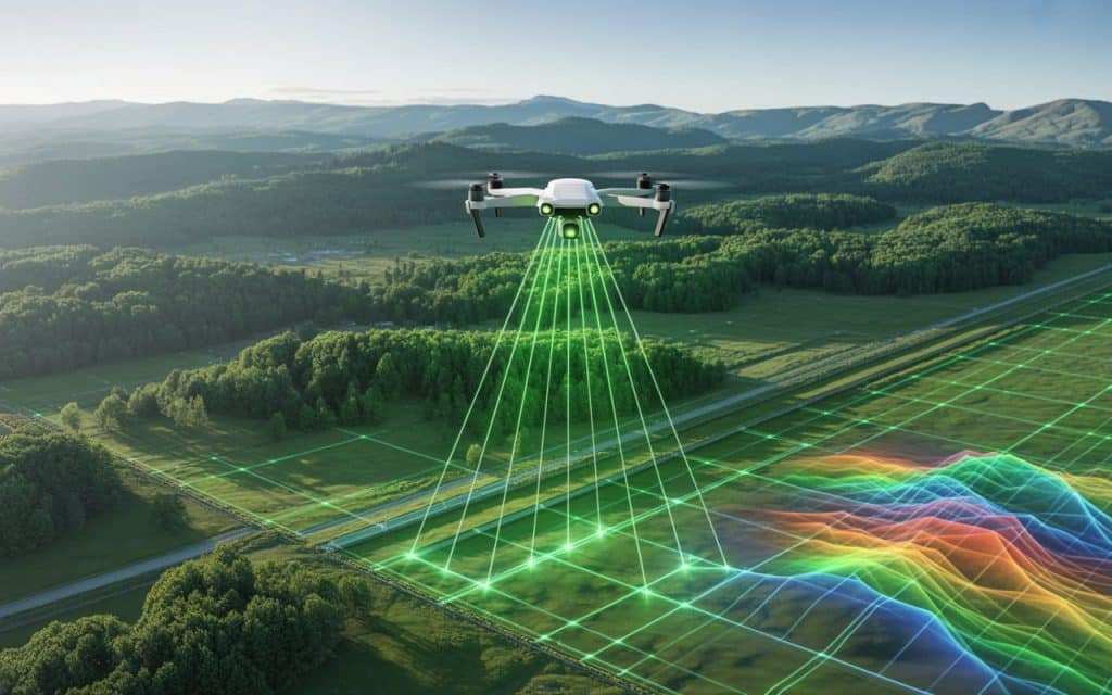
LiDAR works differently. It uses laser pulses to measure the distance between the sensor and the ground. Each pulse creates a precise point in space.
Millions of these points combine to form a detailed three dimensional representation of the landscape. This lidar point cloud data allows engineers, planners and environmental teams to understand terrain conditions without needing extensive ground access.
How lidar mapping works
The lidar mapping process begins with a sensor mounted on a drone aircraft or ground vehicle. The sensor emits thousands of laser pulses per second toward the surface below.
Each pulse reflects back to the sensor. The system records the time it takes for the pulse to return. This timing converts into a precise distance measurement.
When these measurements are combined with GPS and orientation data, they form an accurate digital model of the terrain.
This process is commonly used in airborne lidar survey operations where large areas must be covered quickly and safely.
The advantage of LiDAR for large area mapping
Large scale projects present unique challenges. Terrain may be uneven, remote or covered with dense vegetation.Large area mapping requires a technology that can capture accurate data without requiring physical access to every point on the ground.
LiDAR excels in these conditions. Its laser pulses can pass through gaps in vegetation and reach the ground surface. This makes it ideal for forests, river valleys and mountainous terrain.
In contrast camera based methods may only capture the top of the canopy rather than the true ground elevation.
Learn about: LiDAR scanners, accuracy and real-world uses.
High accuracy elevation data for critical decisions
Many industries rely on high accuracy elevation data to make important decisions. Even small elevation errors can lead to costly problems in design and planning.
LiDAR produces consistent vertical accuracy across large areas. This makes it valuable for applications such as
- Road and rail corridor planning
- Flood risk analysis
- Forestry management
- Mining site evaluation
- Infrastructure development
With terrain mapping lidar systems, engineers can analyze slope drainage patterns and elevation changes with confidence.
Reliable results in forested and remote regions
Canada contains vast forested regions where traditional mapping methods struggle. Dense tree cover often hides the ground surface from cameras.
LiDAR solves this problem by capturing multiple returns from each laser pulse. Some returns come from tree branches while others reach the ground.
This capability allows accurate terrain models even in heavily wooded areas. For forestry planning pipeline routing and environmental studies this level of detail is essential.
Faster coverage over expansive terrain
Speed matters when mapping large landscapes. Ground surveying can take weeks or months to cover remote or rugged areas.
Airborne lidar survey systems can map the same regions in a fraction of the time. Drones and aircraft collect data quickly while maintaining high accuracy.
Faster data collection means:
- Reduced project timelines
- Lower labor costs
- Less disruption to the environment
- Quicker decision making for project teams
For infrastructure and resource projects this efficiency can make a significant difference.
Consistent performance across lighting conditions
Camera based mapping depends on lighting and surface contrast. Poor light or uniform surfaces can reduce accuracy.
LiDAR does not rely on visible light. It measures distance using laser pulses. This allows it to perform consistently in different lighting conditions.
Whether the terrain is rocky forested or shadowed by infrastructure, lidar mapping delivers dependable results.
Supporting infrastructure and environmental planning
Large scale infrastructure projects require precise terrain data. Highways rail lines transmission corridors and pipelines all depend on accurate elevation models.
LiDAR provides the foundation for these projects. Engineers use the data to design routes, analyze slopes and identify potential hazards.
Environmental teams also benefit from lidar mapping. It helps assess flood plains wetlands and habitat conditions across wide regions.
By delivering reliable data across large landscapes, LiDAR supports both development and conservation goals.
Why LiDAR often becomes the preferred choice
When comparing mapping technologies for large landscapes, LiDAR consistently stands out.
It offers
- Accurate ground elevation beneath vegetation
- Fast data collection over large areas
- Reliable results in complex terrain
- Consistent performance regardless of lighting
These advantages make lidar mapping a strong choice for forestry infrastructure construction and environmental projects.
Across Canada, teams working in remote or challenging environments often turn to LiDAR for dependable terrain data. Rekon Solutions supports these projects by delivering precise mapping services tailored to real world conditions.Get in touch here.
FAQs
What makes LiDAR advantageous over traditional cameras in mapping terrain?
LiDAR measures distance using laser pulses rather than relying on visible images. This allows it to capture accurate ground data even under vegetation or in low light conditions.
What is LiDAR in landscaping?
In landscaping and land development, LiDAR is used to create detailed terrain models. These models help with grading drainage planning and site design.
What is the main advantage of LiDAR over photogrammetry?
The main advantage is its ability to capture accurate elevation data beneath vegetation and across complex terrain.
Why is LiDAR so important?
LiDAR provides reliable high accuracy elevation data over large areas. This helps engineers, planners and environmental teams make informed decisions.
How does LiDAR mapping work?
A LiDAR sensor sends laser pulses toward the ground and measures how long they take to return. These measurements create a detailed three dimensional terrain model.
How accurate are LiDAR maps?
LiDAR maps can achieve centimeter level accuracy depending on equipment and survey conditions. This makes them suitable for engineering and infrastructure planning.
