Modern projects demand more than flat maps. Engineers, planners and developers now rely on detailed digital models to understand terrain structures and progress over time.
This is where photogrammetry 3d models have become a powerful tool across construction infrastructure forestry and environmental projects.
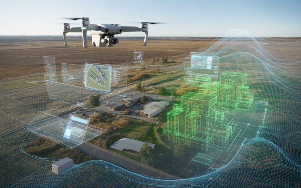
Photogrammetry transforms simple aerial images into accurate three dimensional representations of the real world.
With the help of drones and advanced software, teams can capture vast areas and turn them into precise models for analysis and planning.
What is photogrammetry?
Photogrammetry is a method that creates three dimensional models from overlapping images. A drone or aircraft captures hundreds or thousands of photographs of a site from different angles.
Specialized software then analyzes these images and calculates the position of every visible point.
By identifying shared features across multiple photos, the system reconstructs the shape of the terrain or structure. This process produces detailed photogrammetry 3d models that can be used for measurement planning and visualization.
How does drone photogrammetry work?
Drone photogrammetry has made this technology more accessible and efficient. Instead of relying on manned aircraft or ground crews, drones can capture high resolution images quickly and safely.
The process usually follows a few clear steps.
- First, the drone flies over the project area in a planned grid pattern. This ensures enough image overlap for accurate reconstruction.
- Next, the captured photos are processed through software that identifies matching points across images.
- Finally, the software generates 3d mapping from images, creating a digital surface model, orthomosaic, and full three dimensional representation of the site.
This workflow allows teams to move from raw aerial photos to complete photogrammetry 3d models within a short time frame.
The role of structure from motion
At the core of photogrammetry lies a technique known as structure from motion. This method analyzes the movement and position of features across multiple images.
As the software compares overlapping photos, it calculates how the camera moved between each shot. From this information it determines the spatial position of each point.
The result is a dense point cloud that represents the shape of the landscape or structure. This point cloud is then converted into a surface model or mesh.
Structure from motion is what makes aerial 3d reconstruction possible without needing direct distance measurements.
Benefits of photogrammetry for large projects
Photogrammetry offers several advantages that make it valuable across many industries.
Fast data collection
Drones can capture large areas in a short amount of time. This is especially useful for construction sites or infrastructure corridors where conditions change frequently.
Detailed visual models
Photogrammetric modeling produces highly realistic 3D visuals. These models help teams communicate plans and progress with stakeholders.
Cost efficiency
Compared to some other mapping technologies, drone photogrammetry often requires less expensive equipment. This makes it a practical option for many projects.
Safe access to difficult terrain
Drones can capture data over steep slopes, forests or active construction zones without putting survey crews at risk.
Common applications of photogrammetry 3d models
Photogrammetry is widely used across different industries. Its flexibility and visual clarity make it suitable for a range of tasks.
Construction planning and monitoring
Construction teams use photogrammetry 3d models to track progress, measure volumes and compare design plans with actual site conditions.
Infrastructure development
Road rail and utility projects rely on aerial 3d reconstruction to understand terrain conditions before construction begins.
Forestry and environmental surveys
In open forest areas or regions with moderate canopy cover, drone photogrammetry helps assess land features and monitor environmental changes.
Mining and stockpile measurement
Mining operations use photogrammetric modeling to calculate stockpile volumes and monitor site activity.
Accuracy in photogrammetric modeling
Accuracy in photogrammetry depends on several factors.
- Image quality and resolution
- Overlap between photos
- Flight planning and altitude
- Ground control points
When these factors are managed correctly, photogrammetry 3d models can achieve high levels of accuracy suitable for planning and measurement.
However, dense vegetation or uniform surfaces may reduce reliability. In such cases, other technologies like LiDAR may be considered.
Photogrammetry compared to other 3d mapping methods
Among different 3d mapping methods, photogrammetry stands out for its visual detail and efficiency.
It is particularly effective on open construction sites, urban areas and projects where visual context matters. Teams can see textures, colors and real world features directly in the model.
While other technologies may provide stronger performance under heavy vegetation, photogrammetry remains a versatile and cost effective solution for many mapping tasks.
Learn why LiDAR is now the industry standard.
Why photogrammetry continues to grow in popularity
Advancements in drone technology software processing and computing power have made photogrammetry more accessible than ever.
Projects that once required weeks of fieldwork can now be mapped in a single day. The ability to generate accurate and visually rich photogrammetry 3d models has changed how teams approach planning and analysis.
Across Canada, construction and infrastructure projects increasingly rely on aerial data to improve efficiency and decision making.
Rekon Solutions supports these efforts by helping clients capture accurate site models using advanced drone mapping techniques. Get in touch.
FAQs
What is photogrammetry used for
Photogrammetry is used to create three dimensional models and maps from images. It is commonly used in construction, infrastructure, forestry and environmental projects.
How accurate are photogrammetry 3d models
With proper flight planning and ground control, photogrammetry 3d models can achieve high accuracy suitable for measurement and planning.
What is structure from motion in photogrammetry
Structure from motion is a process that analyzes overlapping images to determine the position of points in three dimensional space.
Is drone photogrammetry better than traditional surveying
Drone photogrammetry can be faster and safer for large areas, but traditional surveying is still important for precise ground control and verification.
