When it comes to mapping and surveying, precision is paramount.
Traditional methods have been relied upon for centuries, but times are changing.
LiDAR technology has emerged as a game-changer, offering high-accuracy results faster and more efficiently than ever before.
In fact, recent 2024 research proves and supports LiDAR’s efficiency and accuracy in complex and vegetated terrains.
While conventional land surveying still holds value, LiDAR is quickly becoming the preferred method.
Thus, understanding the key differences between LiDAR and traditional methods helps you make informed decisions for your projects.
Let’s dive into how LiDAR survey accuracy can transform your mapping and surveying efforts.
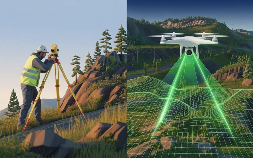
LiDAR vs Traditional Methods: Key Differences
LiDAR (Light Detection and Ranging) uses laser pulses to capture highly accurate measurements of the Earth’s surface.
In contrast, traditional methods rely on physical measurement tools such as tape measures, levels, and theodolites.
Here’s how the two compare:
Traditional Surveying:
- Manual Measurement: Requires more physical presence and effort from surveyors.
- Slower Process: Measurements are taken step-by-step, making the process time-consuming.
- Human Error: Dependent on surveyor skill, which can lead to inaccuracies.
LiDAR Surveying:
- Remote Data Capture: Uses laser sensors, which can quickly map vast areas without physically being there.
- Faster Data Collection: LiDAR scans large surfaces in a fraction of the time compared to manual methods.
- Higher Accuracy: Laser technology ensures a high-precision output, minimizing the risk of human error.
Benefits of LiDAR Over Conventional Land Surveying
LiDAR is revolutionizing the surveying industry by offering clear advantages over traditional methods.
Let’s break down the key benefits of LiDAR survey accuracy:
Speed and Efficiency
LiDAR captures data much faster than traditional methods. A large area can be scanned in a short period, reducing fieldwork time and increasing productivity.
Accuracy
LiDAR’s precision is unmatched, capturing millimeter-level measurements. Traditional methods, while accurate, are prone to small errors due to manual measurements.
Safety
LiDAR allows surveyors to map hazardous or hard-to-reach areas without putting themselves at risk. This makes it ideal for environments such as cliffs, mines, and remote locations.
How LiDAR Improves Mapping Technology Evolution
As the need for faster and more reliable data grows, LiDAR’s role in mapping technology evolution cannot be overstated.
Traditional surveying is often limited by time constraints, accuracy issues, and the need for manual labor.
LiDAR, on the other hand, is enhancing the capabilities of modern surveying in several ways:
3D Mapping
LiDAR creates detailed 3D models that show elevation changes and surface characteristics.
Whereas, traditional methods are typically limited to 2D data or require complex processes to generate 3D data.
High-Precision Mapping
LiDAR’s high precision captures surface details with extreme accuracy, even for complex terrain.
High-precision mapping becomes possible, leading to more reliable decision-making for urban planning, construction, and other industries.
Real-Time Data
LiDAR’s ability to process data quickly provides near-real-time results, allowing faster project planning and execution.
In comparison, traditional methods are more time-intensive, often leading to delays in projects.
LiDAR vs Traditional Methods: Which One is Right for Your Project?
While LiDAR offers clear advantages in terms of speed, precision, and safety, traditional methods still have their place.
It’s important to understand when LiDAR is the best choice, and when conventional surveying might still be applicable.
When to Use LiDAR:
- For large-scale surveying projects requiring high precision.
- For difficult-to-access or dangerous terrain.
- For projects requiring 3D models, such as flood modeling or forest management.
When to Use Traditional Surveying:
- For smaller, simpler projects where speed and precision are not as critical.
- When budget constraints prevent the use of LiDAR technology.
- For projects where historical methods are well-suited and adequate for the task.
The Future of Surveying: LiDAR and Modern Surveying Methods
Looking ahead, modern surveying methods will increasingly rely on LiDAR technology.
As the technology evolves and becomes more accessible, the applications for LiDAR will expand.
LiDAR not only makes surveying faster and more accurate, but it also opens doors to previously impossible projects.
The integration of LiDAR with UAVs (drones) is particularly exciting, as it allows surveyors to capture data from hard-to-reach areas without the need for scaffolding or helicopters.
This is a game-changer in industries like construction, mining, and environmental monitoring.
Learn more: LiDAR in British Columbia: Use Cases, Accuracy & Regulatory Considerations
Advantages of High-Precision Mapping with LiDAR
When high-precision mapping is required, LiDAR is the clear winner.
The level of detail LiDAR provides cannot be matched by traditional surveying methods.
Here are some of the advantages of LiDAR for high-precision mapping:
- Accurate to the millimeter: Provides measurements with high vertical and horizontal accuracy.
- Faster data collection: Allows for faster project execution, which leads to cost savings.
- Versatile: LiDAR can be used in a variety of industries for different types of mapping needs.
Frequently Asked Questions (FAQs)
What’s more accurate, LiDAR or photogrammetry?
LiDAR is generally more accurate than photogrammetry, especially for capturing elevation data. While photogrammetry excels in visual modeling, LiDAR provides precise, reliable measurements for terrain.
What’s better than LiDAR?
Nothing is definitively better than LiDAR for terrain mapping, but a combination of LiDAR and photogrammetry can provide both high precision and visual detail. Each technology complements the other, depending on the project needs.
Is photogrammetry cheaper than LiDAR?
Yes, photogrammetry is generally cheaper than LiDAR, especially for small-scale projects. However, for large and complex projects, LiDAR’s precision and efficiency may justify the higher cost.
Is photogrammetry reliable?
Photogrammetry is reliable when environmental conditions are ideal. However, it can struggle with accuracy in poor lighting or difficult terrain. LiDAR tends to be more consistent across all conditions.
Moving Forward with Confidence
Understanding the strengths and limitations of both LiDAR and traditional surveying methods helps you make the best choice for your project.
LiDAR’s precision, speed, and ability to map complex terrain make it an invaluable tool for modern surveying.
If you are ready to adopt cutting-edge surveying technology, get a quote here or contact our team to learn more about how LiDAR can transform your projects.
