Photogrammetry has revolutionized the way we create detailed maps.
By using overlapping aerial images, photogrammetry allows us to convert raw photos into accurate, 3D maps.
In this blog, we will explore how photogrammetry mapping works, including the process of orthomosaic creation and image-based mapping, and why overlapping aerial images are critical to achieving precision.
When creating a map, the main challenge lies in stitching images together seamlessly. This is where photogrammetric processing and the proper overlap come into play.
Let’s dive into how drone mapping workflow and overlapping images come together to build precise, reliable maps.
What is Photogrammetry Mapping?
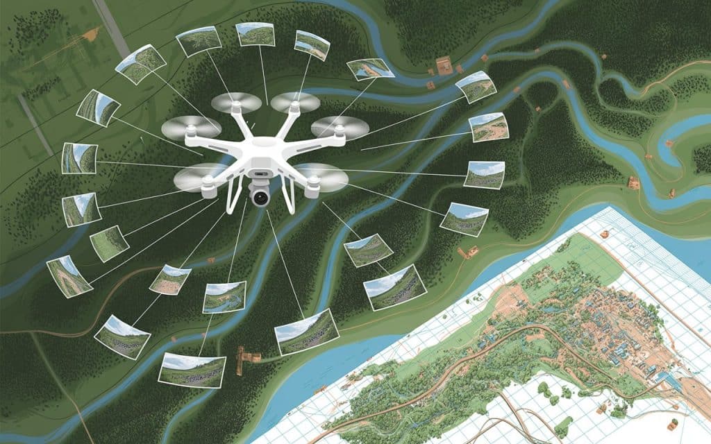
Photogrammetry mapping is the process of converting two-dimensional photographs into accurate three-dimensional maps.
By taking overlapping aerial images of the terrain, photogrammetry uses software to extract geographic data. These data points are then used to generate a map, model, or digital representation of the area.
Drones are commonly used in photogrammetry mapping, capturing high-resolution aerial images from various angles. These images overlap to create accurate 3D models and maps, capturing details that were previously difficult to measure.
The process is efficient and non-invasive, allowing for faster data collection and analysis than traditional surveying methods.
How Overlapping Aerial Images Improve Mapping Accuracy
The key to photogrammetry mapping is the overlapping aerial images captured during flights. These overlapping images are critical for creating a seamless, accurate map.
When an image overlaps with another, it provides the software with common reference points that can be aligned and matched to create a cohesive 3D model.
The more overlap between images, the better the software can identify features and map the area accurately.
In photogrammetry, the term “overlap” refers to the portion of one image that overlaps with the next image in the series. This overlap ensures that the system has multiple perspectives of the same features, which is crucial for precise mapping.
What’s The Process of Orthomosaic Creation
An orthomosaic creation is a key result of photogrammetry mapping.
Once the images are captured and processed, they are stitched together to form a comprehensive, high-resolution map of the area.
This map is referred to as an orthomosaic, which is essentially a distortion-free, true-to-scale image of the terrain.
The process involves aligning the overlapping images so that every detail from the images matches up. This process is what enables the system to generate accurate, realistic maps.
The result is a high-quality map that can be used for further analysis, planning, and even decision-making.
Why Overlap is Crucial in Photogrammetry Mapping
The Importance of Image Overlap in Photogrammetry
Without sufficient overlap, the software would have difficulty matching corresponding points across images. This would lead to gaps, misalignments, or even incomplete data.
Proper overlap ensures that each photo aligns correctly with others, creating a consistent model of the area.
Having at least 60% overlap between aerial images is the standard in photogrammetry. This ensures there is enough shared data between images for precise mapping.
Too little overlap can cause large errors, while too much overlap can result in unnecessary data and increased processing time.
Why is Overlap Important in Photogrammetry?
Overlap provides redundancy, ensuring that important features are captured from multiple angles. This redundancy is key to creating accurate 3D models, as it compensates for any errors in individual photos.
Essentially, the overlap improves the reliability of the entire mapping process, ensuring high-quality results.
Understanding Photogrammetric Processing
Photogrammetric processing is the backbone of creating a 3D model from overlapping aerial images. Once the photos are captured, the software aligns and processes them to extract important data points.
This data is then used to create a 3D point cloud, which is essentially a collection of thousands of points that represent the real-world features of the terrain.
The photogrammetric process involves several steps:
- Image alignment: The software matches corresponding points between images using the overlap.
- Feature extraction: Important features such as edges, contours, and structures are identified.
- 3D model generation: Data points are used to generate a 3D model or map of the area.
This workflow is highly automated, making it fast and cost-effective, and ensuring accuracy and consistency across the data collected.
Learn more: Photogrammetry vs LiDAR: Which One Wins
Drone Mapping Workflow: From Capture to Map
The drone mapping workflow for photogrammetry involves several stages, from capturing the initial aerial images to generating the final map.
Here is how it typically works:
Step 1: Image Capture
- Drones equipped with high-resolution cameras capture aerial images of the area.
- These images should be taken at regular intervals to ensure overlapping aerial images.
Step 2: Image Processing
- The captured images are processed by photogrammetric software to align them and create a 3D model.
- The software uses photogrammetric processing to create a point cloud and mesh.
Step 3: Map Generation
- The final product is either a 2D orthophoto or a 3D model that represents the terrain.
- The map can be used for planning, analysis, and decision-making.
Step 4: Data Analysis
- Once the map is created, it can be analyzed for various purposes such as land use, construction planning, or environmental monitoring.
Benefits of Using Photogrammetry in Mapping
Photogrammetry mapping offers several benefits that make it ideal for large-scale projects:
- Cost-effective: It reduces the need for expensive equipment and manual labor.
- Speed: Drones can capture a large area quickly, significantly reducing the time needed for data collection.
- Accuracy: With proper overlap, photogrammetry can provide highly detailed and accurate maps.
- Flexibility: It can be used in a variety of industries, including construction, agriculture, and environmental monitoring.
FAQs
Why is overlap important in photogrammetry?
Overlap ensures that images have common reference points, which allows software to align and create accurate models. Without overlap, photogrammetry cannot produce a seamless map.
What is the recommended image overlap for accurate photogrammetry?
A 60% overlap is generally recommended to ensure sufficient data for processing. This allows the software to align points from multiple images and create an accurate 3D model.
What is the typical forward overlap used in aerial photogrammetry?
Typically, 70% forward overlap is used in aerial photogrammetry to ensure that the images have enough common points for accurate alignment.
What is longitudinal overlap in photogrammetry?
Longitudinal overlap refers to the overlap between successive flight paths. It ensures that each new set of photos has enough common area with the previous set, ensuring smooth coverage of the entire area.
Moving Forward with Photogrammetry Mapping
Photogrammetry mapping is a powerful tool for creating accurate, detailed maps from overlapping aerial images.This ability to generate orthomosaic creation, 3D models, and detailed terrain maps makes it essential for many industries.
By understanding the importance of overlapping aerial images and how photogrammetric processing works, you can make better decisions in your mapping and surveying efforts.
If you’re ready to take your mapping capabilities to the next level, contact our team to learn how we can help with your next image-based mapping project.
