Imagine you’re tasked with creating a highly detailed topographic map of a rugged landscape.
If you’re relying on traditional surveying methods, the process is slow, expensive, and prone to errors.
But, what if you could complete the task in a fraction of the time, with incredible precision, and without risking safety?
That’s where LiDAR accuracy in surveying comes in.
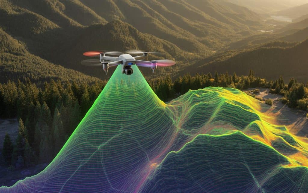
LiDAR (Light Detection and Ranging) has revolutionized how we measure and map the earth’s surface.
With the power of survey-grade LiDAR, precision LiDAR data, and high-accuracy mapping, this technology has taken topographic surveying to new heights—literally.
In this post, we’ll explain why LiDAR is the go-to tool for modern topographic solutions and how it’s reshaping surveying for industries. Let’s dive into how LiDAR elevation accuracy can work for you.
What is LiDAR and How Does It Improve Topographic Accuracy?
LiDAR is a remote sensing technology that uses laser light to measure distances.
By emitting thousands of laser pulses per second, LiDAR can collect precise measurements of the surface below. It is possible even through dense vegetation or hard-to-reach areas. These pulses bounce off the earth’s surface, and the data captured is processed into a 3D model of the terrain.
Unlike traditional surveying methods, LiDAR delivers much higher accuracy and efficiency.
LiDAR accuracy in surveying is unmatched, especially in environments that are challenging for manual surveying.
Whether it’s dense forests or uneven terrains, LiDAR’s ability to penetrate obstacles provides a true representation of the land’s topography.
The Impact of LiDAR on Topographic Surveying
Traditional topographic surveys rely on a lot of manual data collection and calculations. That’s why surveyors often need to travel long distances, set up instruments at multiple locations, and rely on human judgment for measurements. This process can be time-consuming, labor-intensive, and, unfortunately, prone to errors.
With LiDAR, surveyors can capture high-density, high-accuracy data across vast areas quickly and efficiently. Where LiDAR’s precision and high-accuracy mapping capabilities reduce human error significantly.
Not only does this save time and costs, but it also leads to more reliable, detailed, and consistent data.
In fact, a research paper on Improvement of Lidar Data Accuracy Using Lidar-Specific Ground Targets proves that LiDAR can achieve an accuracy level of up to 2- 3 cm under perfect conditions.
This level of precision is a game-changer when it comes to creating topographic maps that are truly representative of the land.
LiDAR Accuracy vs Traditional Surveying Methods
When you compare LiDAR elevation accuracy with traditional survey methods, the differences are stark.
LiDAR surveys provide much more detailed and precise measurements, especially in complex areas.
For instance, when it comes to mapping floodplains or mountainous regions, LiDAR can easily capture elevation changes in minute detail that would be hard to identify with manual methods.
Additionally, LiDAR surveys cover large areas much faster than traditional surveys.
Where a traditional survey might take weeks to complete, a LiDAR survey can be finished in a matter of days, saving time and resources.
Moreover, survey-grade LiDAR systems can cover thousands of acres in a single flight, capturing data over both natural and man-made features with high precision.
The sheer speed and accuracy of LiDAR technology make it an essential tool for industries like construction, forestry, and environmental monitoring.
LiDAR is providing topographic solutions that simply weren’t possible with conventional surveying methods.
Learn more: Drone Inspection Services: Improving Safety, Accuracy & Cost Efficiency
Applications of LiDAR in Modern Topographic Solutions
LiDAR has numerous applications across various industries, but it’s especially valuable in modern topographic solutions.
Let’s look at a few key areas where LiDAR has truly made an impact:
1. Mapping and Infrastructure Planning
LiDAR’s ability to capture precise 3D data makes it ideal for infrastructure planning, including road construction, utilities, and urban development. By providing accurate elevation data, LiDAR enables engineers to design with confidence, ensuring structures are built on stable, well-planned terrain.
2. Environmental Monitoring
LiDAR plays a critical role in monitoring landscapes for environmental protection and resource management. It helps track vegetation changes, measure forest biomass, and even monitor water levels in flood-prone areas.
3. Mining and Resource Extraction
LiDAR is used extensively in the mining industry to survey land and assess mineral deposits.
Its ability to map large areas with precision helps in optimizing resource extraction processes while minimizing environmental impact.
4. Agriculture and Land Management
LiDAR is also becoming an essential tool for precision agriculture. By providing accurate data on elevation, water drainage, and soil erosion, farmers can make better decisions about land use and crop management.
LiDAR vs Traditional Surveying: Which One Wins?
In the debate of LiDAR vs traditional methods, it’s clear that LiDAR offers superior benefits in terms of precision, speed, and cost-effectiveness.
Here’s a quick comparison of both methods:
| Feature | Traditional Surveying | LiDAR |
| Data Accuracy | Prone to human error | High precision (up to 2 cm) |
| Speed | Slow, labor-intensive | Fast, covering large areas quickly |
| Cost | Higher due to labor and equipment | Lower operational costs for large areas |
| Terrain Access | Difficult in rugged or dense areas | Easily penetrates dense vegetation |
As you can see, LiDAR is the clear winner for large-scale, complex topographic surveys.
Its ability to quickly and accurately capture high-quality data far surpasses the capabilities of traditional surveying methods.
Learn more: LiDAR vs. Traditional Methods: The Power of Precision in Mapping
Surveying LiDAR Technology: A Future-Proof Solution
The surveying industry continues to evolve, and LiDAR is leading the way.
With advancements in sensor technology, precision LiDAR data is becoming even more accurate, efficient, and accessible.
More and more industries are adopting LiDAR elevation accuracy for their surveying needs.
Whether it’s for flood risk mapping, large-scale infrastructure projects, or environmental monitoring, LiDAR provides the high-precision data needed to make better decisions.
As the technology continues to improve, we can expect even more innovative uses of LiDAR in surveying and mapping.
It is poised to play a critical role in shaping the future of topographic surveying and other industries.
Frequently Asked Questions (FAQs)
Why is overlap important in LiDAR?
Overlap ensures accurate point cloud generation by creating multiple reference points from different angles. This improves the overall quality of LiDAR mapping, ensuring precision.
What is the recommended image overlap for accurate LiDAR mapping?
Typically, a 60-80% overlap is recommended to ensure that LiDAR data points are well-matched and accurate.
How does LiDAR compare with conventional surveying methods?
LiDAR offers faster, more precise data collection, especially in difficult-to-reach or hazardous areas. Traditional methods are slower and more prone to human error.
How accurate is LiDAR in surveying?
LiDAR can achieve accuracy within 2 cm vertically and 5 cm horizontally, depending on the equipment and environment.
Conclusion
In today’s surveying landscape, LiDAR is the clear winner when it comes to topographic mapping. It provides superior accuracy, speed, and cost efficiency compared to traditional methods. As industries continue to adopt this technology, LiDAR will remain the go-to solution for high-precision mapping and modern topographic solutions.
If you’re looking for reliable LiDAR surveying services, contact us today for a quote or to discuss how we can help you with your next project.
