Accurate terrain information is the foundation of many modern projects.
Construction planning, infrastructure development, environmental studies, and land management all rely on dependable elevation data. Yet collecting precise measurements across large landscapes has always been a challenge.
That challenge is exactly why the topographic LiDAR survey has become so valuable today.
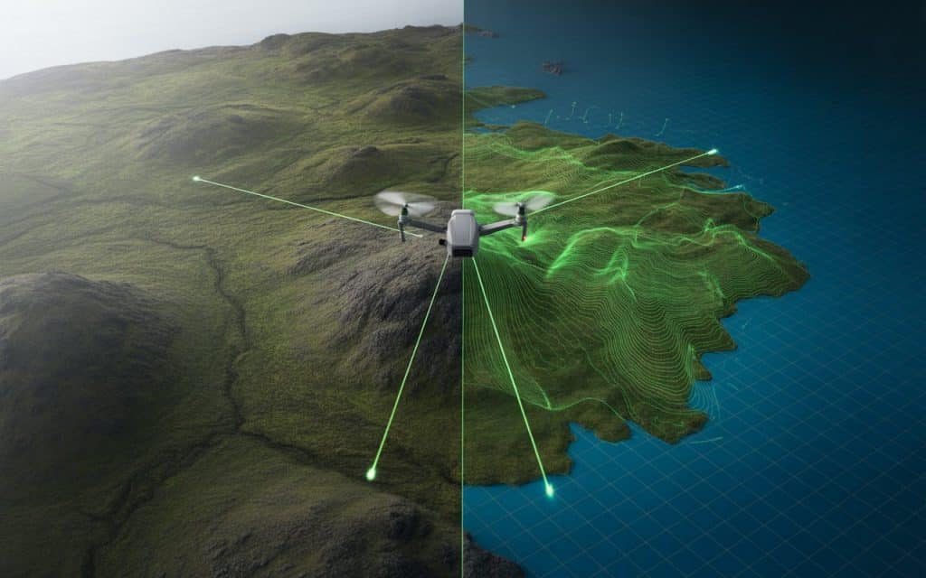
Instead of relying entirely on manual field measurements, LiDAR captures terrain information using laser pulses from airborne sensors.
The result is highly detailed high-resolution terrain data that reveals the landscape with remarkable precision.
When organizations need reliable lidar topography data, they turn to this technology because it provides speed, accuracy, and clarity in ways traditional methods cannot.
Let’s explore how LiDAR unlocks precise terrain mapping and why it plays such an important role in modern surveying.
Why LiDAR is transforming topographic surveys
Topographic surveys traditionally required teams to collect elevation points manually across the landscape. This process worked well for smaller areas but became slow and costly when terrain was complex or difficult to access.
A topographic LiDAR survey changes this approach entirely. Airborne LiDAR sensors emit thousands of laser pulses every second toward the ground. Each pulse measures the distance between the sensor and the terrain surface, creating a dense set of elevation points.
Those points form a detailed dataset known as a point cloud. From that dataset, surveyors can generate maps, terrain models, and elevation analyses. This ability to capture massive volumes of high-resolution terrain data quickly makes LiDAR extremely efficient for large scale mapping.
A study published by the US Geological Survey found that LiDAR can improve elevation accuracy significantly while reducing survey time compared with traditional ground methods.
For projects where time and precision matter, this advantage is difficult to ignore.
How LiDAR collects LiDAR topography data
At the core of LiDAR mapping is laser-based measurement. Sensors mounted on drones or aircraft scan the landscape below and record the time it takes for each laser pulse to return.
Because the pulses travel at the speed of light, extremely precise distance calculations are possible. When combined with GPS positioning and onboard navigation systems, these measurements produce accurate three dimensional terrain information.
This process generates lidar topography data that can reveal subtle elevation changes across large areas. Even complex landscapes with hills, valleys, and varied terrain become easy to analyze.
One of the most valuable outputs of this process is the digital elevation model DEM, which represents the bare earth surface in a digital format.
Understanding the digital elevation model DEM
A DEM (digital elevation model) is one of the most widely used products created from LiDAR surveys. It represents the terrain surface without vegetation or structures, allowing engineers and planners to analyze the landscape accurately.
DEM datasets help professionals study drainage patterns, slope stability, and infrastructure placement. They are essential for flood risk modeling, road design, and environmental assessments.
When generated from a topographic LiDAR survey, DEMs contain far more detail than traditional elevation models. The density of LiDAR measurements allows even subtle terrain features to appear clearly.
This level of detail provides reliable insights that support planning decisions and project design.
The importance of high-resolution terrain data
Terrain resolution directly affects how useful topographic data will be. If elevation points are too sparse, important landscape features may be missed.
LiDAR excels because it produces high-resolution terrain data with thousands of elevation points per square meter. This density provides a detailed representation of slopes, ridges, and drainage channels.
For industries such as infrastructure development, this detail is critical. Engineers rely on accurate terrain information when designing roads, pipelines, and foundations.
If you want to understand how aerial data contributes to modern surveying, our previous article on Photogrammetry Mapping.
Together, these technologies are transforming how spatial data is collected and analyzed.
Elevation mapping technology in modern surveying
Modern surveying has evolved rapidly as digital tools become more sophisticated. Elevation mapping technology now combines aerial sensors, satellite positioning, and advanced data processing to create highly accurate terrain models.
LiDAR plays a central role in this transformation. It enables survey teams to collect elevation information across large areas with minimal field time.
According to research from the National Oceanic and Atmospheric Administration, LiDAR-based elevation mapping improves flood risk modeling accuracy and supports better infrastructure planning.
These capabilities highlight why LiDAR has become essential in modern geospatial analysis.
Contour mapping with lidar for real-world projects
One of the most practical uses of LiDAR data is contour mapping with lidar. Contour lines represent elevation changes across the terrain and are commonly used in engineering and land development.
Traditional contour mapping required surveyors to collect numerous ground measurements across a site. This could take days or even weeks depending on the terrain.
With LiDAR, contour lines can be generated directly from the dense elevation dataset. Because thousands of points are captured automatically, the resulting contours are far more detailed and reliable.
This approach allows planners to visualize terrain more accurately before construction begins.
Applications of topographic LiDAR surveys
A topographic LiDAR survey supports a wide range of industries and projects. While its applications are diverse, several sectors rely heavily on this technology.
Construction and infrastructure planning often depend on accurate elevation data for site preparation. Environmental researchers use LiDAR to analyze landscapes and monitor ecosystem changes.
Mining operations rely on high-precision terrain data for site planning and volume calculations. Forestry teams also use LiDAR to study terrain beneath dense vegetation.
The versatility of LiDAR makes it a valuable tool across many fields.
Can LiDAR be used for topography?
Yes, LiDAR is widely used for topographic mapping and terrain analysis. Its ability to measure elevation accurately across large areas makes it ideal for this purpose.
A topographic LiDAR survey captures dense elevation points that reveal the landscape in detail. These points allow surveyors to create accurate terrain models and contour maps.
Because LiDAR can penetrate gaps in vegetation, it often reveals ground features that traditional methods might miss.
Is LiDAR one hundred percent accurate
No measurement technology is perfectly accurate in every situation. However, LiDAR is considered one of the most reliable elevation mapping technologies available.
Under proper conditions, LiDAR surveys can achieve vertical accuracy within a few centimeters. Factors such as sensor quality, flight planning, and data processing influence the final results.
Despite these variables, LiDAR consistently produces dependable elevation data for surveying projects.
How LiDAR is used in surveying?
In surveying, LiDAR is primarily used to collect elevation measurements and terrain information. Survey teams combine LiDAR sensors with GPS and inertial navigation systems to track the position of each laser measurement.
The collected data is processed into point clouds and terrain models. These datasets support applications such as contour mapping, flood modeling, and infrastructure planning.
If you want to explore how LiDAR compares with other mapping technologies, our previous article on Photogrammetry vs LiDAR explains the differences in detail.
Understanding how each technology works helps teams choose the right solution for their projects.
Rekon expertise in LiDAR surveying
At Rekon Solutions, aerial mapping technologies are used to deliver reliable and accurate terrain data for complex projects. The focus is always on capturing precise measurements and transforming them into useful information.
By combining advanced sensors with proven workflows, the team ensures that every topographic LiDAR survey produces dependable results.
Moving forward with confidence
Accurate terrain information plays a critical role in planning and development. A topographic LiDAR survey provides the detailed elevation insights needed for reliable decision making.
With the ability to generate lidar topography data, digital elevation model DEM datasets, and high-resolution terrain data, LiDAR has become one of the most powerful tools in modern surveying.
When organizations need dependable elevation mapping, LiDAR provides the precision and efficiency required to move projects forward confidently.
If you are considering LiDAR for your next mapping project, contact our team to learn how modern aerial surveying solutions can support your goals.
