Mapping large landscapes has always been a challenge for surveyors and engineers.
Dense forests, rugged terrain, and limited accessibility often make traditional surveying slow, expensive, and sometimes unsafe.
For decades, gathering accurate data across large areas required teams on the ground navigating through vegetation and difficult conditions.
Today, airborne LiDAR mapping is changing that reality.
By using laser-based sensors mounted on aircraft or drones, LiDAR technology can capture incredibly detailed terrain information.
From forestry planning to infrastructure development, LiDAR is redefining how professionals conduct large-area terrain surveys and create highly accurate digital models of the landscape.
What Is Airborne LiDAR Mapping?
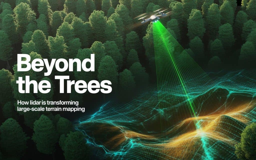
Airborne LiDAR mapping uses laser pulses emitted from a sensor mounted on an aircraft or drone. These pulses travel toward the ground, bounce off surfaces, and return to the sensor.
By measuring the time it takes for each pulse to return, the system calculates precise distances and generates millions of data points representing the terrain.
These points form what is known as a point cloud, which is a highly detailed 3D representation of the landscape.
Unlike traditional aerial photography, LiDAR can capture multiple returns from a single laser pulse.
For example, the first return may reflect from the treetops, while later returns penetrate through branches and leaves to reach the ground surface. This capability allows LiDAR to reveal terrain that would otherwise remain hidden.
The result is a highly accurate dataset that supports 3D terrain modeling, environmental analysis, and engineering design.
Why Traditional Terrain Surveys Struggle in Forested Areas
Traditional mapping methods struggle when terrain is covered by dense vegetation. Survey teams often need to physically access the site, which can involve clearing paths, navigating steep slopes, or working in remote environments.
These challenges can lead to:
- Long survey timelines
- Limited coverage in difficult terrain
- Safety risks for field crews
- Incomplete data in heavily forested areas
In regions with extensive tree cover, the actual ground surface may be almost impossible to measure using conventional techniques.
This is where LiDAR offers a major advantage.
Learn how Aerial Mapping services supports better planning decisions.
Forest Canopy Penetration: Seeing Through the Trees
One of the most powerful capabilities of LiDAR is forest canopy penetration. Because LiDAR sensors emit thousands of laser pulses every second, some of these pulses are able to pass through gaps in the vegetation and reach the ground below.
This allows surveyors to collect elevation data even in areas with dense forest cover.
By capturing multiple returns from each laser pulse, LiDAR can distinguish between different layers of the environment, including:
- Tree canopy
- Branches and vegetation
- Understory growth
- Ground surface
This multi-layer data provides a complete view of the landscape—from treetops down to the terrain beneath.
For forestry professionals and environmental scientists, this ability to see through vegetation is invaluable for understanding ecosystems and monitoring land changes.
Vegetation Filtering with LiDAR
Collecting raw LiDAR data is only the first step. Once the data is captured, specialized software processes the point cloud to separate vegetation from the ground surface.
This process is known as vegetation filtering LiDAR.
Algorithms analyze the point cloud and classify points into categories such as:
- Ground points
- Vegetation points
- Buildings or structures
- Water surfaces
After classification, vegetation points can be removed or filtered out, leaving only the ground points behind. This enables surveyors to generate accurate bare-earth digital elevation models (DEMs).
These filtered terrain models are essential for engineering applications such as road design, drainage analysis, and site planning.
Conducting Large-Area Terrain Surveys Efficiently
Another major benefit of LiDAR technology is its ability to cover large areas quickly.
Traditional ground surveys may take weeks or even months to map extensive terrain. With LiDAR, aircraft or drone platforms can capture data across hundreds—or even thousands—of hectares in a fraction of that time.
For example, airborne LiDAR systems can:
- Survey large forested regions in a single flight
- Capture millions of elevation points per square kilometer
- Map remote areas that are difficult to access on foot
This efficiency makes LiDAR particularly valuable for large-area terrain surveys required in industries such as mining, forestry, and environmental management.
Applications of LiDAR in Forestry and Environmental Studies
The ability to collect detailed terrain and vegetation data has made LiDAR for forestry an essential tool for land managers and researchers.
1. Forest Structure Analysis
LiDAR can measure tree height, canopy density, and forest structure. This data helps forestry teams understand forest health and monitor growth patterns.
2. Habitat and Ecosystem Monitoring
By revealing both vegetation layers and ground terrain, LiDAR supports environmental studies related to wildlife habitats and watershed management.
3. Wildfire Risk Assessment
Detailed vegetation data allows researchers to analyze fuel loads and assess wildfire risks in forested areas.
4. Sustainable Forest Management
LiDAR datasets provide valuable insights that help forestry professionals make informed decisions about harvesting, conservation, and land use planning.
Learn more: The Value of Aerial Inspections for Infrastructure Projects
LiDAR and 3D Terrain Modeling
Once LiDAR data is processed and classified, it can be used to generate highly accurate 3D terrain models.
These models provide a digital representation of the landscape that can be analyzed and visualized in various ways.
Applications of 3D terrain modeling include:
- Engineering design and planning
- Hydrological and flood modeling
- Infrastructure corridor mapping
- Landslide and erosion monitoring
Because LiDAR captures extremely dense datasets, these models can reveal subtle terrain features. It includes small drainage channels, slopes, and elevation changes that might be missed using other mapping methods.
Advantages of Airborne LiDAR for Large-Scale Mapping
Airborne LiDAR offers several advantages compared to traditional surveying techniques.
1. Speed and Coverage
Large landscapes can be surveyed quickly, reducing project timelines and improving efficiency.
2. High Data Density
Millions of elevation points provide extremely detailed terrain information.
3. Access to Remote Areas
Aircraft and drones can map areas that are difficult or dangerous for ground crews to reach.
4. Vegetation Penetration
LiDAR can capture ground data even beneath dense forest canopy.
5. Integration with Other Technologies
LiDAR datasets can be combined with photogrammetry or satellite imagery to produce comprehensive mapping solutions.
The Future of Terrain Mapping
As technology continues to advance, LiDAR is becoming increasingly important in geospatial workflows. Improved sensors, faster processing software, and integration with other mapping tools are making LiDAR more powerful than ever.
In industries that rely on accurate terrain data, the ability to map landscapes quickly and precisely is essential.
Airborne LiDAR mapping is enabling professionals to move beyond the limitations of traditional surveying. It easily reveals terrain hidden beneath vegetation and delivers reliable data across large landscapes.
The Future of Large-Scale Terrain Mapping
Dense forests once made terrain mapping difficult and time-consuming. Today, LiDAR technology allows surveyors and engineers to see beyond the trees and uncover the true shape of the landscape.
Through forest canopy penetration, advanced vegetation filtering LiDAR, and high-density datasets used for 3D terrain modeling, LiDAR is transforming how large landscapes are mapped and understood.
For projects that require accurate, efficient, and large-scale terrain data, LiDAR is no longer just an alternative. Rather it is becoming the standard for modern surveying.
