Drone Inspection Reporting That Works: How to Turn Images into Decisions
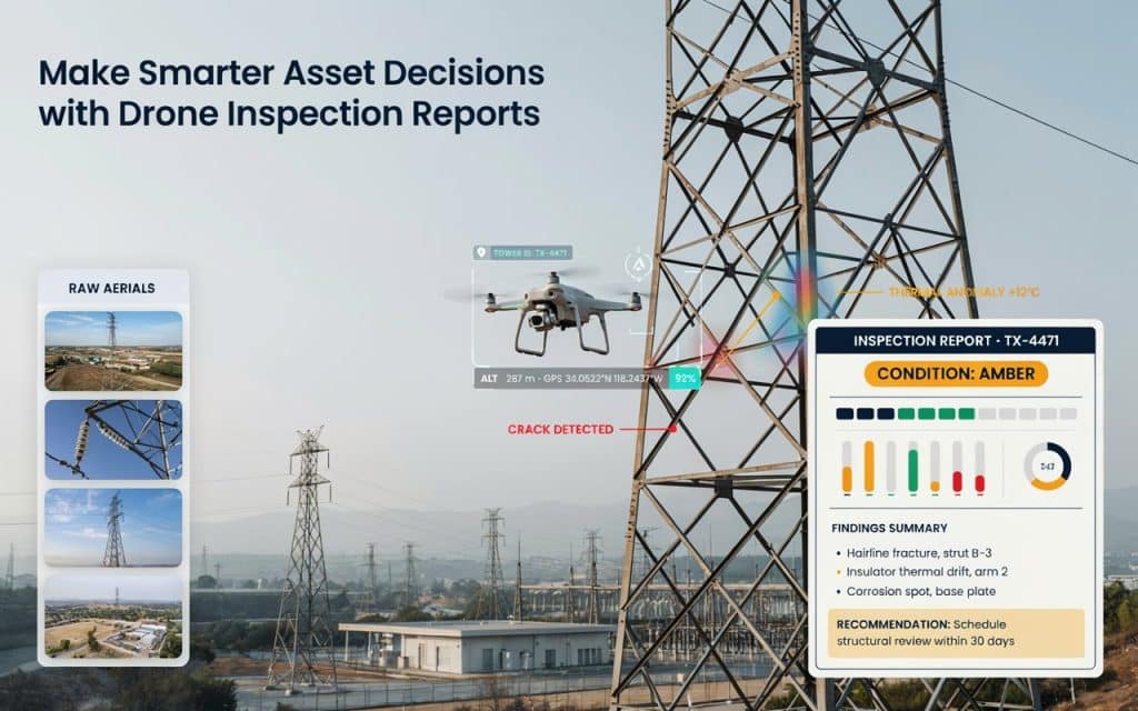
A folder full of drone photos is not the same as an answer. Strong drone inspection reporting is what turns those images into decisions your team can actually act on. Anyone can fly a site and capture thousands of pictures. The real value shows up later, in how that data is read, organised, and explained. Done well, reporting tells you what is wrong, how serious it is, and what to do next. Done poorly, it leaves you scrolling through endless images, still guessing. The payoff for getting this right is real. The US Federal Highway Administration reports that Minnesota’s transportation department saw average cost savings of 40 percent on bridge inspections after adopting drones, along with better data on hard to reach elements, according to the FHWA. So let us look at how to build reporting that works, from raw capture all the way to a clear decision. Why do raw inspection images fall short on their own? Pictures are easy to collect and hard to use. A single flight can produce thousands of frames, and most of them look fine at a glance. The real problem is context. Without structure, you cannot tell which crack matters, how a defect has changed since last time, or where exactly it sits on the asset. This is where a drone inspection report earns its keep. It takes scattered visuals and organises them into findings, locations, and severity, so the data finally means something. Good aerial inspection reporting also creates a record you can return to. Next season, you compare today’s results and see what has moved. In short, drone inspection reporting is what turns raw capture into something useful. What is included in a drone inspection report? A strong report is far more than a photo dump. At minimum, it should pull together annotated images, locations, measurements, and a clear summary of findings. Most reports include marked up images that highlight each defect, along with its exact position on the asset. They also rank issues by severity, often using a simple red, amber, and green system that anyone can read at a glance. Many add measurements, such as crack width or corrosion area, plus recommendations for what to do next. The best visual inspection data reporting ties every finding to a decision, not just an observation. Strong drone inspection reporting also keeps the raw data available, so an engineer can dig deeper whenever a finding needs a closer look. How do you turn inspection images into decisions? This is the heart of it. Capturing data is only step one, and drone inspection data analysis is what actually creates value. First comes review, where trained eyes or software sort through the imagery and flag anything unusual. Modern image based inspection analysis can even use AI to detect cracks, rust, or missing components automatically, which speeds up the slow part of the job. Next comes interpretation. A defect only matters in context, so drone mapping data interpretation links each finding to its location, history, and risk. We explain how raw imagery becomes measurable, mapped data in our guide on how photogrammetry builds a map from overlapping photos. Finally, those findings become drone inspection insights, the clear takeaways that tell your team what to prioritise. That is the difference between data and a decision, and it is the core of good drone inspection reporting. What does a strong drone inspection workflow look like? Reliable results come from a repeatable process. A clear drone inspection workflow keeps every job consistent, from the first flight to the final report. It usually starts with scoping. Before takeoff, you define the asset, the defects you are looking for, and the exact decision the report must support. Then comes capture, processing, analysis, and reporting, with each step feeding the next. When the workflow is tight, your drone survey reporting stays accurate and easy to compare from one inspection to the next. Accuracy matters at every stage, since a decision is only as good as the data behind it. We cover how to trust those numbers in our guide on how accurate drone LiDAR is for engineering and construction projects. A strong workflow is the backbone of dependable drone inspection reporting. Frequently asked questions How do drone inspections work? A drone flies a planned path and captures images or sensor data of an asset. That data is then processed, analysed, and compiled into a report that supports a clear decision. Why use drones for inspections? They keep people out of dangerous spots, cover hard to reach areas fast, and gather consistent data every time. Strong drone inspection reporting then turns that data into action. What industries use drone inspections? Construction, mining, energy, utilities, and infrastructure all rely on them. Anywhere assets are large, remote, or risky to access, drones add real value. How accurate are drone inspections? Very, when done properly. With good capture and processing, drone data can reach centimetre level detail, and clear reporting makes that accuracy usable. How to make your reporting drive real decisions In the end, the goal is simple. Your inspection should leave you knowing exactly what to do next, not buried in a pile of files. That only happens when capture, analysis, and reporting work as one connected system. Strong reporting links every image to a finding, every finding to a risk, and every risk to an action. If you want inspection data that drives confident decisions, rather than more questions, let us help. Tell us about your assets and the calls you need to make, and Rekon Solutions will build reporting designed to answer them.
Photogrammetry for Construction: What to Capture, What to Deliver, and What to Avoid
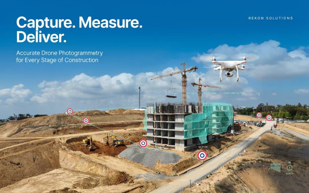
Drone photogrammetry construction work can save you weeks, or it can hand you a model nobody trusts. The difference is almost always in the details. Done right, a single flight gives you an accurate, current view of the whole site. Done wrong, you get a pretty picture that quietly misleads your design team. The good news is that the rules are simple once you know them. Accuracy comes down to a few key choices, and one of the biggest is ground control. A peer reviewed study in Remote Sensing found that the number and placement of ground control points directly drives the accuracy of UAV photogrammetry outputs, according to MDPI. So here is what to capture, what to deliver, and what to avoid on your next site. What should you capture on a construction site? Good output starts with good capture. Before takeoff, you plan a flight that covers the whole site with heavy image overlap, usually around 70 to 80 percent. That overlap lets the software match points across photos and build a solid model. For most construction site photogrammetry, you also fly at a steady height with consistent lighting to keep the imagery clean. Ground control is the next must have. You place marked targets across the site and measure them with survey grade GPS, which anchors the model to real coordinates. For trickier sites, capture both straight down and angled images. This helps the software reconstruct vertical faces, stockpiles, and structures during drone mapping construction site work. Smart capture is the foundation of every drone photogrammetry construction survey. What deliverables should a construction survey produce? Once the data is processed, you should receive a clear set of products, not just a raw point cloud. The core deliverable is usually an orthomosaic, a precise, map accurate image of the whole site. From there, you get a digital surface model, contour lines, and a 3D model you can measure. Strong aerial photogrammetry construction outputs also include volume reports for cut, fill, and stockpiles, plus cross sections where your team needs them. Most teams want these in formats that drop straight into their design tools. Good 3D mapping construction site data should open in your CAD or BIM software without a fight, so nobody wastes a day converting files. We explain how those overlapping photos become measurable maps in our guide on how photogrammetry builds a map from overlapping photos. That process is the engine behind every deliverable in drone photogrammetry construction work. What mistakes should you avoid? Now for the part that saves you grief. The most common mistake is skipping or rushing ground control, which is exactly what the research above warns against. Another is weak overlap. Fly too fast or too high, and the software cannot stitch the images cleanly, which leaves holes and warping in the model. Watch the conditions too. Strong shadows, wet surfaces, water, and moving equipment all confuse photogrammetry, so timing your flight matters more than people expect. We cover these accuracy drivers in our guide on how to get your surveying right with photogrammetry. Finally, do not treat every site the same. Dense vegetation hides the ground from a camera, so heavily treed sites may need LiDAR instead. These mistakes are what separate reliable drone photogrammetry construction work from a model nobody trusts. How does photogrammetry support construction progress monitoring? Beyond the first survey, the real power shows up over time. Flying the same site on a schedule turns single snapshots into a clear progress record. A construction progress monitoring drone lets you compare this week to last, measure earthworks, and catch issues early. You can see exactly how much material moved and whether the work on the ground matches the plan on paper. This is where drone surveying construction earns its budget. Instead of guessing, your team makes decisions from current, measured data. Frequent construction site 3D mapping also builds a documented history. That record is gold for billing, disputes, and handover, since you can prove what the site looked like on any given day. Repeat flights are where drone photogrammetry construction proves its long term value. The cost per visit drops, the data stacks up, and you end up with a complete timeline of the build rather than a few scattered surveys. Frequently asked questions How accurate is drone photogrammetry on a construction site? With proper ground control and planning, it commonly reaches 2 to 5 centimetre accuracy. That is enough for design, earthworks, and most construction needs. Do you need ground control points for construction photogrammetry? For accurate, report grade results, yes. Ground control anchors the model and is the single biggest driver of accuracy on a site. How often should you fly a construction site? It depends on the pace of work. Many active sites are flown weekly or monthly to track progress and measure volumes. Can photogrammetry replace ground surveyors on construction? Not entirely. Drone photogrammetry construction surveys cover large areas fast, but licensed surveyors still handle legal boundaries and certified points. How to get construction photogrammetry right In the end, the formula is simple. Capture with care, deliver what your team can actually use, and avoid the shortcuts that wreck accuracy. Get those three right, and drone photogrammetry construction work becomes one of the most reliable tools on your site. You plan from real data, track progress with confidence, and catch problems before they cost you. If you have a site coming up, tell us what you need to build and how you will use the data. Rekon Solutions will plan the capture, the deliverables, and the quality checks to match, so your model is one you can build on.
How Thermography Helps Prevent Costly Failures?

Imagine your industrial facility’s HVAC system suddenly failing during a heatwave, causing major downtime and damage. What if you could have detected the fault before it happened, preventing the disruption and saving thousands of dollars? This is exactly where thermal drone inspection comes in. By using advanced infrared thermography surveys, thermal drones can quickly identify problems. It can detect defects like heat loss, electrical faults, and structural issues before they lead to expensive breakdowns. Thermal imaging for infrastructure is changing the game for asset managers and facility operators, allowing for early detection and predictive maintenance. In this blog, we’ll explore how thermography helps prevent costly failures and keeps operations running smoothly. What is Thermal Drone Inspection? Thermal drone inspection is the process of using drones equipped with thermal cameras to capture infrared images of equipment, buildings, or infrastructure. These images help identify temperature variations that can indicate potential issues. The issues may include electrical faults, heat loss, or moisture problems. Unlike traditional visual inspections, thermal drones allow inspectors to quickly scan large areas without disrupting operations. The high-resolution thermal imaging they provide reveals subtle temperature differences that are invisible to the naked eye. But, most often, those turn out to be the first signs of underlying issues. For instance, in electrical systems, infrared thermography surveys can detect overheating components, loose connections, or circuit overloads before they lead to equipment failure. In industrial facilities, thermal imaging for infrastructure ensures that systems run efficiently and avoid costly downtime. How Thermography Prevents Costly Failures The ability to detect problems early with thermal drone inspection offers significant advantages for businesses. Whether it’s a heat loss detection issue in a building or electrical fault detection in a factory, thermography helps avoid breakdowns. Where these breakdowns could otherwise result in expensive repairs or unsafe working conditions. Studies have shown that implementing predictive maintenance techniques, like infrared thermography, can reduce downtime by up to 50% and lower maintenance costs by 30%. When you can identify and fix problems before they disrupt operations, you prevent costly failures, reduce unplanned maintenance, and extend the lifespan of critical assets. Predictive Maintenance Technology Thermal drone inspections are a key component of predictive maintenance technology. Predictive maintenance relies on data and diagnostics to predict equipment failure before it occurs. By regularly using infrared thermography surveys, maintenance teams can monitor the health of machines and systems in real time, taking action before issues escalate. For example, electrical faults are often preceded by increased heat in components, such as transformers or circuit breakers. Thermal imaging for infrastructure makes it possible to spot these hot spots early, allowing technicians to replace or repair components before they fail. This shift from reactive to proactive maintenance helps avoid emergency repairs and improves overall system reliability. Applications of Thermal Drone Inspections Heat Loss Detection in Buildings Thermal drones are commonly used in energy audits to identify heat loss in buildings. By scanning building envelopes, drones can find areas where insulation is inadequate or air leaks are present. This information helps building owners improve energy efficiency, reduce heating and cooling costs, and ensure comfort for occupants. Electrical Fault Detection in Industrial Settings In industrial facilities, electrical systems are prone to overheating, which can lead to catastrophic failures if not addressed. Thermal drone inspection allows for quick detection of overheating components, identifying potential problems before they cause shutdowns or fires. This is particularly valuable in large facilities with complex electrical systems, where inspecting every component manually is both time-consuming and risky. Infrastructure Health Monitoring Drones equipped with thermal cameras can inspect large-scale infrastructure like bridges, dams, and pipelines. These structures are constantly exposed to environmental stress, which can lead to cracks, leaks, or corrosion. Using thermal drones to detect temperature anomalies can help identify areas of concern, ensuring that infrastructure remains safe and operational. Mechanical Equipment Monitoring Thermal imaging is also used to monitor mechanical equipment in factories or on construction sites. By identifying hot spots in motors, bearings, or pumps, thermography helps detect mechanical issues such as friction, misalignment, or lubrication failure. Addressing these issues early prevents more severe failures and extends the life of equipment. The Advantages of Using Thermal Drone Inspections The primary advantages of using thermal drone inspection include: Speed: Drones can quickly cover large areas, allowing for faster inspections than traditional methods. Safety: Drones can access dangerous or hard-to-reach areas, reducing the need for workers to put themselves at risk. Non-invasive: Thermal inspections are non-destructive, meaning that no physical contact is required with the equipment being inspected. Real-time data: Drones provide immediate feedback, enabling faster decision-making. These benefits make thermal drones an indispensable tool in industries such as construction, energy, manufacturing, and infrastructure. How Accurate is Thermal Drone Inspection? The accuracy of thermal drone inspection depends largely on the quality of the drone’s thermal camera and the experience of the operator. High-end thermal cameras can detect temperature differences as small as 0.1°C, providing highly accurate readings. However, while thermal drones are highly accurate, environmental factors can impact the results. For instance, extreme weather conditions, such as rain, snow, or direct sunlight, can affect the thermal signature of objects. It’s also important to note that infrared thermography surveys work best when the surface being inspected has a significant temperature difference from its surroundings. With proper calibration and optimal conditions, thermal drones provide accurate, reliable data that can be used for preventative maintenance and asset management. If you’re looking for more information on how drones are revolutionizing inspections, check out our blog on How Drone Inspections Improve Safety and Accuracy. FAQs: Thermal Drone Inspections How is thermal imaging used in inspections? Thermal imaging uses infrared technology to detect temperature variations. In inspections, thermal drones capture infrared images of equipment, buildings, or infrastructure to identify issues like heat loss, electrical faults, or leaks that may not be visible to the naked eye. How accurate is thermal drone inspection? Thermal drones are highly accurate, with high-end thermal cameras capable of detecting temperature variations as small as 0.1°C. However,
Bathymetry Basics for Rivers and Lakes: What You Can Map and What You Might Miss
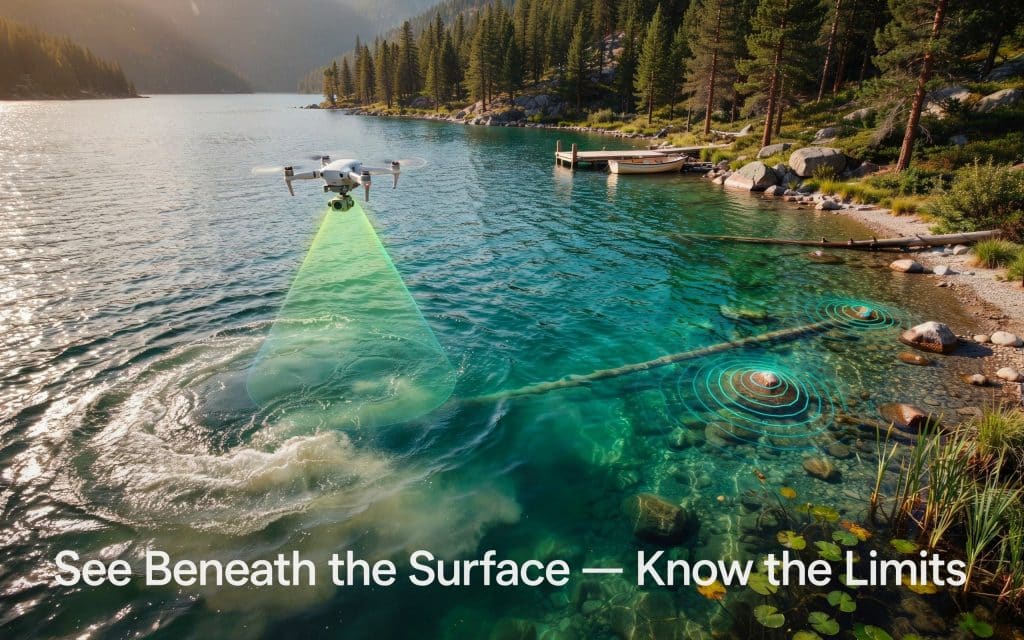
Mapping the bottom of a river or lake once meant a boat, a sonar unit, and a lot of slow passes. A bathymetric survey drone changes that picture. From the air, it can read the shape of the bed beneath shallow, clear water in a single flight. No boat ramp, and no crew out on the water. This opens the door to faster, safer surveys of shorelines, channels, and crossings. But it is not magic, and its limits matter as much as its strengths. So let us look at what a drone can map below the surface, and what it can quietly miss. What bathymetry maps? Bathymetry is the study of underwater depth and the shape of the bed below. Think of it as topography, but for the part hidden under water. A bathymetry mapping project turns those depths into a clear picture of the bottom. You see channels, drop offs, sandbars, and holes that you could never spot from the surface. For rivers and lakes, that picture supports flood planning, habitat work, dredging, and bridge design. Today, a bathymetric survey drone can build it faster than older methods ever could. How does drone bathymetry work? A bathymetric survey drone usually carries a green laser sensor. Green light passes through clear water, bounces off the bed, and returns to the sensor. The system times each pulse to work out the depth. This is one of the newer underwater mapping techniques, and it pairs neatly with normal land scanning in the same flight. Older bathymetry survey methods rely on boats with sonar. They work well in deep or murky water but are slow in the shallows. Traditional hydrographic survey methods also need safe water access, which is not always possible on a fast river. By contrast, drone water depth measurement covers shallow edges and braided channels quickly, with the crew safe on the bank. That makes aerial water depth mapping a strong fit for the tricky zone where land meets water. What can you map with a bathymetric survey? In the right conditions, the results are impressive. A bathymetric survey can capture the bed in fine detail wherever the water is clear and calm. How deep can it see? In clear water, green laser systems can reach roughly two to three times the Secchi depth, with vertical accuracy near 10 centimetres, according to Hydro International. The Secchi depth is simply how far down you can see a marker before it vanishes. This makes a river bathymetry survey ideal for mapping channels, gravel bars, and bank erosion. A lake bathymetry mapping flight can chart shallow shorelines, inlets, and submerged features in one pass. Because a bathymetric survey drone records land and shallow water together, you get a seamless model from dry ground to the river bed. That single, connected dataset is the real strength of an aerial bathymetric survey. What you might miss Now for the honest part. The water has to cooperate, and it often does not. Cloudy or muddy water stops the laser fast. One government study found that depth penetration dropped from about 7 metres in clear water to roughly 3 metres in turbid water, according to Caltrans. Whitewater and rapids are another blind spot. Foam and broken surfaces scatter the light, so fast, churning sections often go unmapped. Deep water is a limit too. Below the laser reach, a bathymetric survey drone simply cannot see the bottom, and you need sonar instead. Thick weed, algae, and heavy shade can also hide the bed. Choosing the right method So which tool should you use? It comes down to the water and the goal. For shallow, clear rivers and lake edges, a bathymetric survey drone is hard to beat on speed and safety. For deep, murky, or open water, sonar from a boat still wins. Many projects use both. The drone maps the shallows and shoreline, while sonar handles the deep middle. Together they give full coverage with no risky wading. Accuracy still depends on planning and processing, the same way it does on land. We explain those accuracy drivers in our guide on how accurate drone LiDAR is for engineering and construction projects. In addition, you can also learn about how LiDAR copes with rugged sites in how LiDAR performs in dense forest and mountain terrain. If you are weighing your options, Rekon Solutions can help you match the method to your water and your goals. Contact us with your project details. Frequently asked questions What are the key features of a bathymetric map? A bathymetric map shows water depth and the shape of the bed. Key features include depth contours, colour shading for depth, and submerged shapes like channels, bars, and holes. What is bathymetry mapping? Bathymetry mapping is the process of measuring underwater depth and turning it into a map of the bottom. It works like topography for the area beneath the water, and a drone with a green laser is one fast way to collect that data. What do the colours on a bathymetry map mean? Colours usually show depth. Lighter shades, often blue or green, mark shallow water, while darker shades mark deeper water. A legend tells you the exact range for each colour. How do you read a bathymetry map? Start with the legend to learn the depth colours and the contour spacing. Closely spaced lines mean a steep drop, while wide spacing means a gentle slope. Map your water with confidence Bathymetry from the air is a powerful tool, as long as you respect the water. In clear, shallow rivers and lakes, a bathymetric survey drone delivers fast, detailed depth data that would take a boat crew far longer to gather. The trick is knowing where it shines and where sonar should take over. Match the method to the conditions, and you end up with a complete, reliable picture of the bottom. If you have a river or lake that needs mapping, tell us about the site and the water clarity. We
When Should You Choose Drone LiDAR Over Traditional Land Surveying?
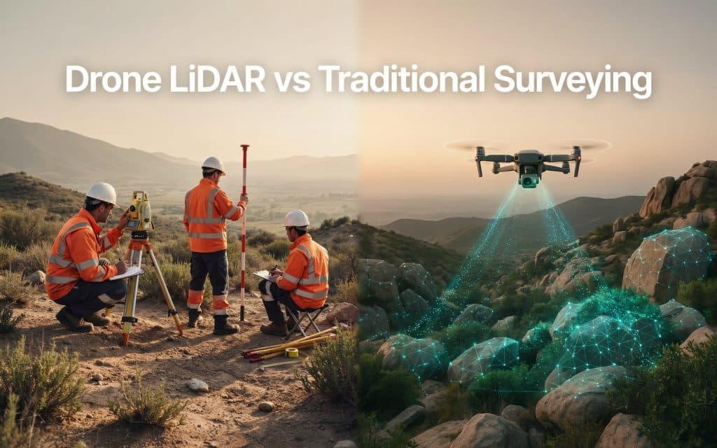
Picking between drone lidar vs traditional surveying can be tricky. And the wrong choice can cost you weeks. Both methods can give great results. But they work best in very different places. When you match the method to the site, you save time and money. You also avoid paying for data you cannot really use. So this guide will not just pick a winner. It will show you when each one is the smart choice for your project. What drone LiDAR and traditional surveying each do well First, let us see how each one works. A drone lidar survey shoots fast laser beams from the sky. It measures how long each beam takes to bounce back. Those beams build a thick cloud of points that maps the ground. A lidar land survey can even map land hidden under trees. Traditional land surveying works the other way. A crew walks the site with ground tools and marks points one at a time. These conventional survey methods have been trusted for many years. They still work great in the right job. That is the heart of the drone lidar vs traditional surveying question. It is not about which tool is newer. It is about which one your project really needs. Choose drone LiDAR when terrain and access are hard Some sites are just hard on people. Steep hills, thick bushes, and far away land slow a crew down. They can also be risky. This is where drone lidar vs traditional surveying leans toward the sky. A drone flying above can reach ground that would take days to cover on foot. The amount of data is huge. In fact, no ground crew can match that by hand. In one study, a drone sensor collected about 1.2 million points every second. It even mapped a creek hidden by trees, where normal photos could not see the banks at all. You can read this in the ISPRS Archives. LiDAR is also strong in thick forests and tall mountains. Its beams slip through small gaps in the leaves to reach the ground. We explain this more in our post on how LiDAR performs in dense forest and mountain terrain. For big areas, long roads, or any place you do not want to send a person, lidar mapping technology usually wins on speed and safety. Keep traditional land surveying when legal lines must be exact It is easy to think LiDAR always wins. But that is not true. Some jobs still need ground surveying methods. Legal land lines are the best example. When a property line or land title must be official, you need a licensed surveyor. A manual land survey carries legal weight that drone data alone does not. Small, simple lots can also fit the old way better. If you only need a few exact points on one lot, a drone may add cost and extra work for no real gain. So the modern vs traditional surveying choice is often about rules and size, not just speed. Knowing when to use the proven method is smart, not old fashioned. This is a part of the drone lidar vs traditional surveying talk that people often skip. How to choose the right method for your project Most real projects sit somewhere in the middle. A few simple questions can settle the drone lidar vs traditional surveying choice. Start with the land. If it is steep, far, or covered in trees, the drone is usually the better pick. Next, think about size. Big or long sites reward the speed of one flight. Then think about what you need at the end. For official boundaries, use a surveyor. For a full map, ground shapes, or volume counts, a drone lidar survey is the better tool. Worried about accuracy? The gap is smaller than most people think. We cover this in how accurate drone LiDAR is for engineering and construction projects. Last, look at your time and money together. The fastest way is not always the cheapest once the data is processed. In fact, many teams stop treating this as drone lidar vs traditional surveying. They use both. The drone maps most of the site fast. Then a surveyor checks the few points that need legal proof. In British Columbia, where land can run from valleys to mountains, this mix often works best. Frequently asked questions 1. Is drone LiDAR more accurate than traditional land surveying? For land shape and terrain, a good drone lidar survey can be correct to within a centimetre. That is close to ground methods. But for official legal lines, a licensed surveyor is still needed. 2. Which method is faster for a large site? Drone LiDAR, by far. It can map in hours what a crew might need days to cover on foot. 3. When is traditional surveying still the better choice? When the job needs legal proof, like property lines and titles. Small, simple lots can also be a good fit for conventional survey methods. 4. Can you use both methods on one project? Yes, and many teams do. The drone covers the wide land, and a surveyor locks in the legal points. So the lidar vs traditional survey choice often ends in a smart mix. How you can make the right call for your next survey The best move is not to pick a side before you look at the work. Look at your land, your goal, and your deadline. Then choose the method that fits. If your site is steep, wooded, or very large, the drone lidar vs traditional surveying math usually points to flying. If a legal boundary is on the line, keep a licensed surveyor on the team. And when the job pulls both ways, use both. Still staring at a map and unsure? That is exactly the time to ask before you spend a dollar. Send Rekon Solutions a few details about your site and your goals here. You will get a clear, honest answer on the best method, with no
How Drone Photography is Changing the Game for Surveying
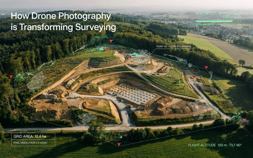
Surveying has always been about gathering accurate information. The challenge is that collecting that information often takes significant time, effort, and resources, especially across large or difficult sites. Today, that process looks very different. With drone photography for surveying, teams can capture detailed site data from the air in a matter of hours instead of days. It creates a faster and more efficient approach to modern surveying. This shift is not simply about replacing boots on the ground. It is about giving surveyors better visibility, safer access, and more complete datasets that support better decisions throughout a project. According to McKinsey & Company, commercial drone applications could generate between $31 billion and $46 billion in economic impact annually, with surveying and mapping among the fastest-growing professional uses. So what exactly is driving this change, and why are more project teams incorporating drones into their surveying workflows? Why Traditional Surveying Can Slow Projects Down Traditional surveying methods remain valuable and necessary in many situations. However, collecting measurements point by point across large areas can be time consuming. The challenge becomes even greater when terrain is steep, heavily vegetated, or difficult to access safely. Survey crews often need additional time, equipment, and personnel to gather the required information. As project schedules become tighter and sites become larger, organizations are looking for ways to collect accurate data more efficiently. How Drone Photography Fits Into Modern Surveying At its core, drone photography for surveying uses carefully planned flight paths to capture hundreds or even thousands of overlapping photographs. Those images are processed using photogrammetry software to create detailed maps, elevation models, and three-dimensional representations of the terrain. Instead of recording individual survey points one at a time, drones capture an entire site in a single coordinated workflow. This dramatically reduces field time while providing a much broader view of site conditions. What Makes Survey Grade Drone Imagery So Valuable Speed is important, but accuracy matters even more. Modern survey grade drone imagery can achieve centimetre-level accuracy when supported by proper flight planning, control points, and processing workflows. From a single mission, surveyors can generate: Orthomosaic maps Surface models Contour maps Volume calculations Progress documentation Site condition records Perhaps most importantly, every image becomes part of a permanent visual record that can be reviewed long after the flight is complete. Where Aerial Photography Surveying Creates the Biggest Benefits Different industries use drone technology in different ways. However, the benefits often come back to the same core advantages: speed, safety, and visibility. 1. Construction and Development Construction teams use aerial photography surveying to understand site conditions before work begins and to track progress throughout the project lifecycle. Frequent flights provide updated site information that helps keep stakeholders aligned and reduces the risk of working from outdated data. 2. Mining and Resource Projects Remote sites often present logistical challenges for traditional field crews. Drones make it possible to capture large areas quickly while reducing the amount of time personnel spend navigating difficult terrain. This supports planning, stockpile management, and ongoing operational monitoring. 3. Environmental Monitoring Environmental projects often require repeatable data collection over extended periods. Drone imagery helps teams monitor erosion, vegetation changes, watershed conditions, and land use impacts without disturbing the surrounding environment. How UAV Photography Mapping Improves Safety Safety is often discussed as a secondary benefit of drones, but for many projects it becomes one of the most important advantages. Certain locations expose survey crews to risks such as unstable slopes, active construction zones, water crossings, or difficult terrain. With UAV photography mapping, much of that information can be collected remotely while personnel remain in safer locations. The drone performs the site access while the survey team focuses on data quality and project objectives. Why Drone Data Capture Is Becoming Standard Practice Several factors have accelerated adoption in recent years. Drone technology continues to improve. Cameras capture more detail, batteries support longer flight times, and processing software delivers increasingly sophisticated outputs. At the same time, project owners are demanding faster access to accurate information. The result is a growing reliance on drone data capture as part of everyday surveying operations rather than as a specialized service. If you want the data to hold up under real planning, the workflow matters, and our article on how to get your surveying right with photogrammetry walks through it. How Drone Photography Works Alongside Other Survey Methods One common misconception is that drones replace every other survey technology. In reality, drones are most effective when integrated with other modern surveying tools. For example, photogrammetry performs exceptionally well on open terrain where imagery can clearly capture surface features. However, dense vegetation may require LiDAR to accurately measure the ground beneath the canopy. That is why many projects combine multiple technologies to achieve the best possible outcome. You may also find value in reading How Photogrammetry Builds a Map From Overlapping Photos to better understand how aerial imagery becomes measurable survey data. What Should You Look for in a Survey Provider? Technology alone does not guarantee accurate results. Flight planning, control point placement, processing workflows, and quality assurance all influence the final deliverables. An experienced provider understands how site conditions affect data quality and selects the right workflow for the project rather than relying on a single approach. That expertise is often what separates useful data from data that supports confident decision-making. If you are evaluating surveying options for an upcoming project, Rekon Solutions can help determine the most effective approach based on your site conditions, objectives, and accuracy requirements.Get in touch with our team here. Frequently Asked Questions 1. How accurate is drone photography for surveying? With proper planning and control, drone surveys can achieve centimetre-level accuracy suitable for many surveying and mapping applications. 2. Is drone surveying faster than traditional surveying? In many cases, yes. Drones can capture large areas in a few hours that may otherwise require several days of fieldwork. 3. Can drones survey difficult terrain? Yes. Drones are particularly effective in areas that are steep,
Thermal Imaging vs Visual Inspection: What Each Method Can (and Can’t) Reveal
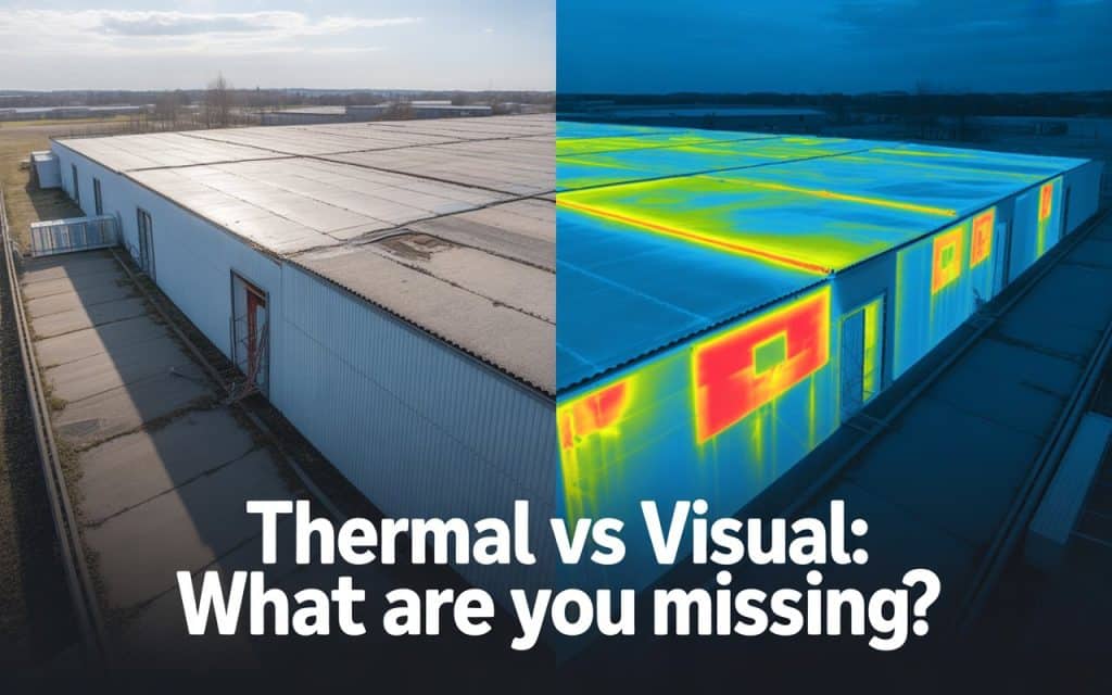
Many inspection programs rely heavily on what can be seen with the human eye. Cracks, corrosion, missing components, and visible damage are all important indicators of asset condition. However, not every problem is visible on the surface. Some issues develop long before visual signs appear. Heat loss, moisture intrusion, electrical faults, and insulation failures often remain hidden until they become costly problems. This is where a drone thermal inspection offers a different perspective. Rather than replacing visual inspections, thermal imaging adds another layer of information. Understanding what each method can and cannot reveal helps organizations make better maintenance and inspection decisions. Let’s compare both approaches and explore where each delivers the most value. Why Visual Inspections Remain Important Visual inspections have been the foundation of asset assessment for decades. They provide direct observation of physical conditions and help identify visible defects quickly. In many situations, they remain the first step in evaluating asset health. Inspectors can identify: surface cracks corrosion loose components structural damage material deterioration Visual inspections also provide context that helps interpret broader site conditions. This makes them valuable across infrastructure, construction, and industrial environments. However, visual assessments are limited to what can actually be seen. Hidden defects often remain undetected until symptoms become more obvious. What a Drone Thermal Inspection Reveals A drone thermal inspection measures temperature variations across surfaces and structures. Instead of capturing only visible imagery, thermal sensors detect heat signatures that may indicate underlying problems. This allows inspectors to identify issues that would otherwise remain invisible during standard inspections. Small temperature anomalies often reveal developing defects before visible damage appears. For example, thermal inspections can detect: insulation failures moisture intrusion electrical hotspots heat loss mechanical overheating This capability makes thermal technology particularly valuable for preventive maintenance programs. Understanding Thermal Imaging vs Visual Inspection The discussion around thermal imaging vs visual inspection is not about choosing one method over the other. Instead, it is about understanding how the two approaches complement each other. Visual inspections reveal physical conditions directly. Thermal imaging reveals temperature patterns and hidden performance issues. Together, they provide a more complete understanding of asset health. A visible crack may indicate structural deterioration. A thermal anomaly may indicate a hidden moisture issue beneath an apparently intact surface. Both findings are valuable but reveal different aspects of the asset. The strongest inspection programs often combine both methods rather than relying on one alone. How Drone Infrared Inspection Services Improve Detection Modern drone infrared inspection services allow thermal data to be collected safely and efficiently from difficult locations. Roofs, towers, industrial facilities, and utility infrastructure can all be inspected without extensive physical access. This improves safety while expanding inspection coverage. Inspectors gain access to viewpoints that may be difficult or costly to reach manually. Additionally, drones can capture thermal imagery consistently across large areas. This helps create comprehensive records for comparison over time. As assets age, these repeatable inspections become increasingly valuable for condition monitoring. Further Reading: How Accurate Is Aerial Thermal Imaging Heat Loss Detection? Building Heat Loss Drone Inspection Applications One of the most common uses for thermal technology is building heat loss drone inspection. Energy loss often occurs through roofing systems, wall assemblies, windows, or poorly insulated areas. These deficiencies may not be visible during conventional inspections. Thermal imagery highlights areas where heat escapes unexpectedly, allowing teams to identify opportunities for improvement. For facility managers, this information supports: energy efficiency initiatives maintenance planning insulation assessments sustainability programs By locating heat loss early, organizations can address inefficiencies before energy costs continue to increase. Thermal Drone Survey Accuracy and What Affects It Like any inspection method, thermal drone survey accuracy depends on several variables. Environmental conditions play a significant role in how thermal data is collected and interpreted. Factors affecting thermal accuracy include: ambient temperature wind conditions solar exposure surface materials inspection timing For example, inspections performed during peak sunlight may produce different thermal patterns than inspections conducted at dawn or dusk. Experienced operators understand how these variables influence results. Proper planning helps ensure thermal findings accurately represent asset conditions. How Infrared Thermography Drones Support Maintenance Programs Modern infrared thermography drones have become valuable tools for proactive asset management. Instead of waiting for failures to occur, organizations can identify warning signs earlier. Thermal inspections often reveal developing issues before visible symptoms emerge. This supports predictive maintenance strategies that reduce downtime and repair costs. Common applications include: electrical system monitoring industrial equipment inspections facility management infrastructure maintenance This early detection capability is one of the strongest advantages of thermal technology. You can also learn more about How Drone Inspections Improve Safety and Accuracy. Why Roof Thermal Inspection Is So Effective A roof thermal inspection is one of the clearest examples of thermal imaging value. Moisture trapped beneath roofing materials often remains hidden during visual assessments. As moisture affects thermal behavior, infrared sensors can identify areas requiring further investigation. This helps maintenance teams focus repairs where they are most needed. Thermal inspections also reduce the need for extensive exploratory work. Instead of examining large roof sections manually, teams can target specific locations efficiently. This improves both inspection speed and maintenance planning accuracy. Energy Audit Drone Thermal Imaging Benefits Organizations focused on energy efficiency increasingly use energy audit drone thermal imaging to evaluate building performance. Thermal data helps identify areas where energy losses occur throughout facilities. This information supports: building performance assessments retrofit planning sustainability initiatives operational cost reduction According to the MDPI report, correcting building envelope deficiencies can reduce heating and cooling energy usage by 15% to 30%. Thermal inspections help provide the data needed to support these improvements. Defect Detection Thermal Imaging Drones Can Improve One of the strongest applications for defect detection thermal imaging drones involves identifying hidden conditions before they become visible failures. Temperature anomalies often act as early warning indicators. Examples include: electrical overheating moisture intrusion insulation degradation mechanical stress points While thermal imaging does not diagnose every issue directly, it helps identify areas requiring closer investigation. This allows maintenance teams to
How Accurate Are Drone Inspections? Limits, Measurement Tips, and QA Methods
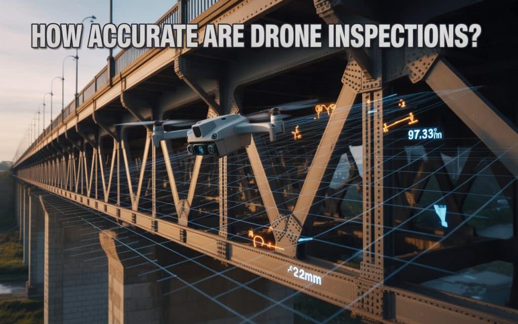
Drone inspection accuracy is the foundation of good decisions in inspection and infrastructure projects. Whether you manage industrial facilities, or construction projects, the quality of your inspection data directly affects safety, maintenance planning, and operational costs. If the data is unreliable, even the best decisions can be based on incorrect assumptions. This is why drone inspection accuracy has become an important topic across multiple industries. Drones can collect detailed visual and measurement data faster than traditional methods. However, many people still wonder how accurate drone inspections really are and what factors influence the results. The answer depends on more than the drone itself. Sensor quality, flight planning, environmental conditions, and quality assurance workflows all play a role. Let’s look at what determines inspection accuracy, where limitations exist, and how professional teams ensure reliable results. Why Drone Inspection Accuracy Matters Every inspection aims to answer a simple question. What is the current condition of the asset being inspected? The accuracy of that answer depends entirely on the quality of the collected data. High levels of drone inspection accuracy help identify defects earlier and support more confident maintenance decisions. This reduces the risk of missed issues and unnecessary repairs. It also improves long term asset management. For industries responsible for critical infrastructure, accurate inspections can prevent costly failures and unexpected downtime. Reliable data helps teams prioritize resources more effectively. How Accurate Are Drone Surveys in Real Projects One of the most common questions clients ask is how accurate are drone LiDAR surveys compared to traditional inspection methods. The answer varies depending on project requirements and technology selection. Modern drones equipped with high resolution cameras can detect small visual defects from safe distances. When combined with photogrammetry or LiDAR workflows, drones can also provide highly accurate measurements and spatial data. According to research published by the ASPRS (American Society for Photogrammetry and Remote Sensing), properly planned drone mapping workflows can achieve centimeter level accuracy under suitable conditions. This makes drones valuable tools for many inspection and survey applications. The key phrase here is properly planned. Accuracy depends heavily on workflow quality rather than equipment alone. 4 Factors That Influence Inspection Accuracy Several variables affect inspection performance during every project. Understanding these factors helps set realistic expectations and improve outcomes. Sensor Quality Higher quality sensors capture more detailed information. Camera resolution, thermal sensitivity, and LiDAR performance all affect the quality of collected data. Flight Planning Proper overlap, flight altitude, and viewing angles influence inspection results. Poor planning can create gaps or reduce measurement reliability. Environmental Conditions Wind, lighting, precipitation, and atmospheric conditions can affect image quality. Stable conditions generally produce more consistent datasets. Operator Experience Experienced teams understand how to adapt flight plans and processing workflows to site conditions. This improves overall reliability significantly. These variables all contribute to final inspection accuracy. Understanding UAV Inspection Accuracy Limits Although drones provide impressive capabilities, every technology has constraints. Understanding UAV inspection accuracy limits helps avoid unrealistic expectations. For example, visual inspections depend on line of sight. If a defect is hidden behind structural elements, the drone may not capture it directly. Lighting conditions can also influence visibility. Distance from the asset affects image detail as well. While zoom lenses help, excessive stand off distances may reduce defect detection capability. Additionally, certain measurements require specialized sensors rather than standard cameras. Understanding these limitations is part of responsible project planning. Industrial Drone Inspection Accuracy in Practice An industrial drone inspection often involves challenging environments. Facilities may contain tall structures, confined spaces, active equipment, or hazardous locations. Traditional inspections in these settings can expose personnel to significant risks. Drones improve safety by reducing the need for direct access. At the same time, they collect detailed visual records from multiple perspectives. Industries commonly using drone inspections include: Oil and gas facilities Power generation sites Manufacturing plants Mining operations Transportation infrastructure In these environments, accuracy and repeatability are often just as important as safety improvements. Measurement Accuracy Drone Mapping Can Achieve Many inspections involve more than visual observations. Teams often require measurements for crack monitoring, deformation analysis, volume calculations, or dimensional verification. This is where measurement accuracy drone mapping becomes important. Photogrammetry and LiDAR workflows allow drones to generate measurable spatial datasets. These datasets support engineering analysis and asset management programs. Accuracy depends on factors such as: control point quality sensor calibration overlap settings processing standards environmental conditions When these variables are managed properly, drone measurements can provide highly reliable results. Construction Drone Inspection Reliability Construction projects depend on accurate information throughout every phase. Progress tracking, quality control, and site verification all require dependable data. Strong construction drone inspection reliability helps project teams monitor work more efficiently. Drones provide frequent site updates without disrupting operations. This improves communication between stakeholders and supports faster issue identification. Additionally, drone inspections create consistent historical records. Teams can compare site conditions over time and verify progress against project plans. This level of visibility helps reduce misunderstandings and improve accountability across construction workflows. If you are interested in why drone inspection is better, read this: What Can Drone Inspections Detect That Ground Crews Miss Why a Drone Inspection QA Process Is Essential Accurate data does not happen by accident. Professional providers follow a structured drone inspection QA process to verify data quality before deliverables are released. A typical QA workflow may include: flight plan verification sensor calibration checks data completeness review processing validation coordinate verification deliverable inspection These steps help identify potential issues before results reach the client. Quality assurance is often the difference between visually appealing outputs and genuinely reliable inspection data. Inspection Data Validation Methods That Improve Reliability A strong inspection workflow includes multiple inspection data validation methods. Validation ensures the collected information accurately represents field conditions. Common validation techniques include comparing drone measurements against known control points. Teams may also conduct field verification of identified defects. Cross checking datasets from multiple sensors can further improve confidence. Some projects require independent reviews before final acceptance. These practices help ensure that inspection findings are
Bathymetry How to Map What’s Hiding Under the Surface

What lies beneath the water often matters just as much as what sits above it. Rivers shift over time, lakebeds collect sediment, and coastal zones constantly change shape. Yet many projects still rely on outdated underwater data or incomplete manual measurements. This is why a drone bathymetric survey is becoming increasingly valuable across modern infrastructure and environmental projects. Instead of relying only on boats and manual probing, drones now help collect accurate underwater terrain data faster and more safely. Moreover, they allow teams to access areas that were previously difficult or expensive to survey. Whether you are planning construction, studying erosion, or managing flood risks, understanding underwater terrain changes everything. Let’s look at how modern bathymetry works and why drone technology is transforming underwater mapping. What a Drone Bathymetric Survey Actually Does A drone bathymetric survey measures underwater terrain and water depth using aerial or water-based sensing technologies. The goal is to create detailed models of submerged landscapes such as riverbeds, lake bottoms, coastlines, and reservoirs. Depending on the project, drones may use sonar systems, optical sensors, or LiDAR-based solutions. These tools collect depth information while covering large areas efficiently. The resulting data is then processed into terrain models and depth maps. Unlike traditional surveys, drone workflows improve accessibility significantly. This makes underwater mapping more practical for challenging or remote environments. Why Underwater Terrain Data Matters More Than Ever Many projects depend on accurate underwater information, even when the work itself happens above ground. Infrastructure planning, flood analysis, and environmental monitoring all rely on understanding submerged terrain conditions. For example, erosion beneath bridges can weaken structural stability over time. Sediment buildup in reservoirs can reduce water storage capacity. Coastal changes can also affect flood behavior and shoreline protection. This is where bathymetry mapping technology provides critical insight. By revealing hidden terrain beneath the water surface, teams can make better engineering and environmental decisions earlier. How Underwater Mapping Drone Systems Work An underwater mapping drone does not always travel beneath the water itself. In many cases, aerial drones carry specialized sensors capable of measuring shallow water conditions from above. These systems collect both positional and depth information simultaneously. Some projects also combine aerial drones with autonomous watercraft for deeper survey coverage. Together, they create highly detailed underwater terrain models. The workflow usually includes: flight or navigation planning sensor calibration depth data collection terrain processing map generation These steps help ensure reliable underwater mapping outputs. Why Hydrographic Survey Drone Services Are Growing The demand for hydrographic survey drone services continues increasing because traditional methods can be slow and resource intensive. Boat-based surveys often require larger crews, difficult access, and longer project timelines. Drones reduce many of these limitations. They improve access to shallow zones, confined waterways, and environmentally sensitive areas. This makes data collection safer and more efficient. Additionally, drones help reduce operational disruption. Projects can often continue while mapping activities take place nearby. According to the National Oceanic and Atmospheric Administration, bathymetric mapping plays a critical role in nautical charts, changing coastline features, and marine life monitoring. This growing demand reflects how valuable underwater terrain data has become across industries. The Role of Shallow Water LiDAR Mapping One of the most advanced developments in bathymetry is shallow water LiDAR mapping. This technology uses laser pulses to measure underwater terrain through clear water conditions. Unlike traditional topographic LiDAR, bathymetric LiDAR systems use specific wavelengths capable of penetrating water surfaces. This allows drones and aircraft to capture elevation and depth data together. This is especially useful for: coastal mapping river corridors shallow lakes shoreline monitoring floodplain analysis Because it works remotely, bathymetric LiDAR applications improve safety and efficiency significantly. Mapping Lakes Rivers and Coastal Areas Different water environments require different survey approaches. A lake mapping drone survey may focus on sediment buildup, shoreline erosion, or water storage analysis. River surveys often prioritize flow behavior and channel movement. In river systems, accurate riverbed mapping techniques help identify erosion zones and flood risks. Understanding riverbed shape also improves infrastructure planning near waterways. Meanwhile, coastal mapping drones support shoreline monitoring and environmental protection. Coastal terrain changes rapidly due to tides, storms, and erosion. Drone surveys help teams monitor these shifts consistently. These mapping workflows support both engineering and environmental objectives. Learn more: Aerial Mapping Services: How Drone Data Supports Better Planning Decisions Why Water Depth Measurement Drone Workflows Improve Safety Traditional underwater surveys sometimes expose crews to difficult environments. Fast-moving rivers, unstable shorelines, or shallow obstructions can create safety concerns during manual operations. A water depth measurement drone reduces many of these risks by limiting direct field exposure. Drones can collect depth information remotely while operators remain at safer locations. This also improves efficiency during surveys involving remote or hazardous terrain. Teams can collect large amounts of data without extensive physical access requirements. Additionally, drones reduce environmental disturbance compared to heavier equipment and larger survey vessels. Understanding UAV Hydrographic Survey Methods Modern UAV hydrographic survey methods combine aerial positioning with underwater sensing technologies. The goal is to collect accurate terrain information while maintaining efficient field operations. Some methods rely on optical depth estimation in clear water environments. Others use sonar-equipped autonomous systems paired with aerial drones. Bathymetric LiDAR may also be used for shallow coastal and river mapping. The right method depends on: water clarity survey depth terrain complexity vegetation presence required accuracy Experienced providers evaluate these factors before selecting a workflow. Challenges That Affect Bathymetric Surveys While drone workflows improve efficiency significantly, underwater mapping still involves technical challenges. Water clarity is one of the biggest factors affecting optical and LiDAR-based systems. Turbidity, waves, reflections, and vegetation can all influence data quality. Deep water environments may also require sonar instead of aerial methods. Additionally, weather conditions affect flight stability and visibility during data collection. This is why planning and sensor selection remain critical parts of every project. An experienced provider understands how to adapt workflows based on site conditions instead of relying on one method everywhere. If your project involves lakes, rivers, or coastal environments,
How Accurate Is Aerial Thermal Imaging Heat Loss Detection?
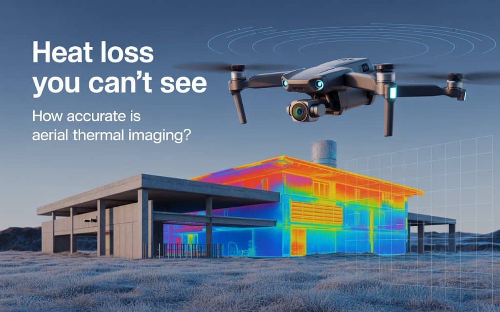
Heat loss is one of the most expensive and least visible building performance issues. If you want to find where your building is losing heat, you may not see the problem with your eyes. That is why aerial thermal imaging heat loss surveys are popular. They let you scan a roof or exterior walls fast and spot unusual hot or cold areas. In this blog, you will learn what this method can do, how accurate it is, and what you should check before you trust the results. In this blog, you will learn how accurate this method is, what affects the results, and what you should do so you can trust the findings. You will also see when you should follow up with other tests, because thermal images are powerful but not perfect. What is aerial thermal imaging and how does it work? A drone can carry an infrared (IR) camera. This camera detects heat coming from surfaces and turns it into a thermal image, also called a thermogram. The image uses colors or shades to show warmer and cooler areas. This is a form of thermal imaging for heat loss detection. It does not “see through” walls. Instead, it shows surface temperature patterns. Because heat moves through materials, surface patterns can hint at problems behind the surface, such as: Missing or damaged insulation Air leaks around joints, edges, or penetrations Wet insulation that changes heat flow Thermal bridging (heat moving through metal or concrete paths) When you use a drone, you can scan big areas faster than walking the full roof with a handheld camera. Therefore, you save time and you reduce the need for risky work at height. What does “accuracy” mean in heat loss thermal imaging? When people ask about accuracy, they often mix two ideas. It helps if you separate them. Temperature accuracy vs. decision accuracy First, there is temperature measurement accuracy. This is about how close the camera’s temperature reading is to the true surface temperature. This topic is part of the accuracy of thermal imaging heat detection. Many things can affect the number, such as camera settings and surface type. Second, there is decision accuracy. This is about whether the thermal pattern leads you to the right conclusion. For example, you might see a warm strip on a roof and conclude “there is missing insulation.” However, that warm strip could also come from sunlight or a material change. Therefore, a good report should explain why the area is a likely heat loss point, and it should recommend the next step to confirm it. So, heat loss thermal imaging is usually very strong at finding “where you should look.” But it is less reliable if you want to calculate the exact heat loss rate without other data. How accurate is aerial thermal imaging heat loss detection in real buildings? In real projects, aerial thermal imaging heat loss results can be very useful, but accuracy depends heavily on conditions. If you control the timing, weather, and flight plan, you can get clear and repeatable patterns. Consequently, your decisions become better and faster. However, if you scan on a windy day, right after rain, or in strong sunlight, the images can be confusing. Because of that, the “accuracy” can drop, even if the camera itself is high quality. A practical way to think about it is this: Drone thermography is excellent for screening large roof areas and spotting unusual hot/cold zones. It is good for prioritizing where you should do repairs or further tests. It is not a standalone proof of energy performance. Therefore, you should confirm high-cost decisions with follow-up inspection. Factors that affect your results (and what you can do) 1. Temperature difference between inside and outside Thermal patterns are easier to see when there is a strong temperature difference. If the building is heated and the outdoor air is cold, heat loss spots often show up clearly on the outer surface. However, if indoor and outdoor temperatures are close, the contrast is weak. Then the camera may not show enough difference to interpret confidently. Therefore, you should aim for conditions that create good contrast. 2. Wind, rain, and wet surfaces Wind can cool surfaces quickly. Because wind increases heat transfer at the surface, it can hide real heat loss patterns. Rain and wet roofs can also change the surface temperature and how the surface “looks” in infrared. So, if you want better results, you should avoid scanning during rain and preferably avoid scanning soon after rain. Also, you should document wind speed and general weather in your report. That simple step makes your findings more defensible. 3. Roof materials and reflections Some materials are easy to read. Others are tricky. For example, shiny metal can reflect the cold sky and look “strangely cold,” even when it is not losing heat. That is why heat loss infrared thermal imaging should always include normal photos. When you compare the thermal image with the visual photo, you can tell whether a hot spot is a real defect or just a material change, patch, or reflective surface. 4. Sunlight and time of day Sunlight is one of the biggest causes of confusion. A roof heated by the sun can stay warm, even after the sun goes away. Then you might think you found a heat loss area, but it could be leftover solar heating. Because of this, many teams plan scans when solar effects are low and temperatures are stable. Therefore, timing should be part of your plan, not an afterthought. 5. Flight height and image detail The drone flight height affects resolution. If the drone is too high, each pixel covers a larger area. Consequently, small gaps in insulation may disappear. If the drone is too low, you may miss coverage or have safety issues near obstacles. A planned flight path gives you consistent coverage and consistent viewing angles. That makes comparisons easier across the roof. Where drone thermal imaging fits in a building envelope check
