How Accurate Are Drone Volume Measurements with Photogrammetry?
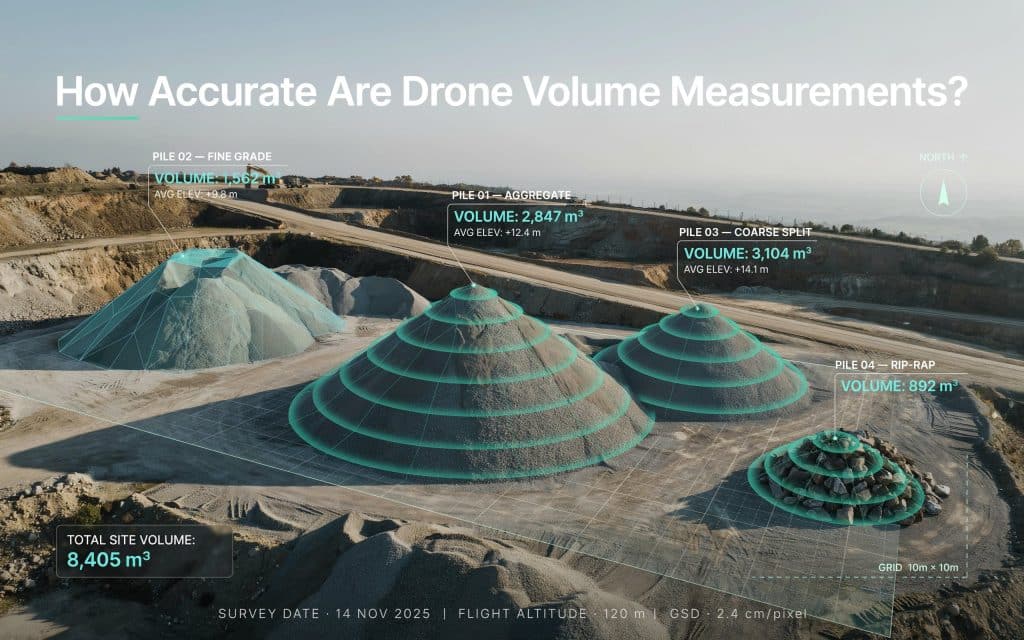
If you have ever doubted a stockpile number, you are not alone. Drone volume measurement accuracy is one of the first things teams want to understand before they trust the results. The good news is that the technology has matured a great deal. Today, photogrammetry can measure piles and pits with impressive precision. In fact, one peer reviewed study found that drone volumes matched a traditional ground survey within 0.7 percent on a pile of more than 530,000 cubic metres, and repeat flights of the same pile agreed within 0.2 percent, according to research published in Geomatica. So how does this actually work, and what separates a number you can bank on from one you cannot? Let us walk through it together. How drones measure volume with photogrammetry Before we talk about accuracy, it helps to know how the number is made. A drone flies a planned grid and snaps hundreds of overlapping photos of the site. Software then turns those photos into a detailed 3D model of the surface. This step is the photogrammetry volume calculation, and it compares the shape of the pile against a base level to work out how much material is there. Because the drone captures the whole pile, not just a few points, the model reflects the real shape of the material. We break down how those overlapping images become measurable data in our guide on how photogrammetry builds a map from overlapping photos. This is what makes it possible to calculate volume using drone mapping in a single short flight, even on large or awkward piles. So how accurate are drone volume measurements really Here is the part you came for. When the workflow is done properly, drone volume calculation accuracy typically lands within a few percent of ground truth, and often much closer. The study mentioned above is a strong example. Its drone survey accuracy volume calculation came within 0.7 percent of the ground based result on a very large pile, and the repeat flights were even tighter. That level of photogrammetry accuracy volume measurement is more than enough for most reporting, billing, and planning needs. For many operations, an aerial volume measurement is now as trusted as a manual one, and far faster to produce. Still, drone volume measurement accuracy is not automatic. It depends heavily on how the survey is planned and processed. What affects drone volume measurement accuracy? Several things decide whether your volumes come out tight or loose. The first is ground control. Placing measured control points around the site, or flying with an RTK drone, anchors the model to real world coordinates. Flight planning matters too. Good image overlap, a steady altitude, and clear lighting all help the software build a clean surface. The base surface under the pile is another big factor. If the software has to guess the ground beneath the material, the volume can drift. A known base level keeps the drone surveying volume calculation honest. Finally, the shape and texture of the pile play a role. Smooth, well formed piles are easier to measure than steep, uneven ones. We cover these accuracy drivers in more depth in our guide on how to get your surveying right with photogrammetry. Get these right, and your volume measurement accuracy drone survey results stay consistent from one flight to the next. Why stockpile teams rely on drone volume numbers? Nowhere is this more useful than on stockpiles. A single drone volume measurement can check inventory across a whole yard in one visit, with no one climbing a pile. For quarries and mines, that speed changes how often you can measure. Monthly counts can become weekly, or even on demand. Strong drone volume measurement accuracy means those frequent checks still hold up for reporting. This is the exact problem we tackle on our page about volume discrepancies in quarry stockpiles. A drone stockpile measurement flight can cover dozens of piles at once, and each one is measured the same way every time. Moreover, a stockpile measurement drone also removes the guesswork from reconciliation, which is often worth as much as the raw accuracy itself. How to get volume results you can trust? If accurate volumes affect your bottom line, a few habits make all the difference. Use ground control or RTK on every flight that feeds a report. Keep your flight settings consistent, so each survey can be compared fairly to the last. Set a clear base surface before you calculate, rather than letting the software assume it. Most importantly, work with a team that treats accuracy as the goal rather than an afterthought. Rekon Solutions plans each flight around your site and your reporting needs, so your drone volume measurement accuracy holds up when it counts. Frequently asked questions How accurate are drone volume measurements with photogrammetry? With proper ground control and planning, results commonly fall within a few percent of a ground survey, and often under 1 percent on large, well formed piles. Do you need ground control points for accurate volumes? For report grade numbers, yes. Ground control or an RTK drone anchors the model and keeps drone volume calculation accuracy consistent across surveys. How long does a drone volume survey take? Often a single short flight, plus processing time. A drone can measure many piles in the time a ground crew would need for just one. Is drone volume measurement accuracy good enough for billing? In most cases, yes. When the workflow is sound, the numbers are trusted for inventory, billing, and planning alike. Putting Accurate Volume Data to Work for Your Site At the end of the day, a volume number is only useful if you believe it. The reassuring part is that drone volume measurement accuracy, done well, stands shoulder to shoulder with traditional methods. In addition, it delivers those numbers faster and more safely. The difference comes down to the workflow behind the flight. Solid control, smart planning, and careful processing turn a quick flyover into a figure you can
How Accurate Is Drone LiDAR for Engineering and Construction Projects?
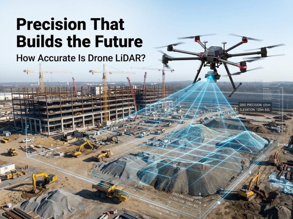
When it comes to precision in construction and engineering projects, accuracy is the bedrock on which everything is built. Whether you’re mapping out a construction site or surveying terrain for a new infrastructure project, the need for precise data is critical. One tool that’s revolutionizing how surveys are conducted is drone LiDAR (Light Detection and Ranging) technology. But how accurate is drone LiDAR, and how does it compare to traditional survey methods? In this blog, we will explore how drone LiDAR works, how accurate it really is, and why it’s becoming indispensable for both engineering and construction professionals. Let’s dive into the world of drone LiDAR accuracy and how it’s transforming site surveying and construction mapping technology. What Is Drone LiDAR and How Does It Work? Before diving into the accuracy of drone LiDAR, it’s essential to understand how it works. LiDAR is a remote sensing technology that uses laser pulses to measure distances between the sensor (mounted on a drone) and the target surface. These laser pulses travel to the ground, bounce off objects, and return to the sensor. The system then measures the time it takes for the pulse to return, calculating the distance and creating a detailed 3D map of the surveyed area. Drone LiDAR systems are particularly advantageous in construction and engineering because they allow for high-resolution, high-precision mapping. This makes it easier to capture topography, terrain models, and more without needing to rely on traditional ground-based survey techniques. How Accurate Is Drone LiDAR for Engineering and Construction Projects? Drone LiDAR accuracy is a critical consideration for construction and engineering projects, where precision is everything. With traditional surveying methods, errors can creep in due to human limitations or the environment. Drones equipped with LiDAR sensors can achieve high levels of lidar accuracy, significantly reducing the margin for error. In general, drone LiDAR systems can achieve accuracy levels as precise as 2-5 cm (centimeters), which is comparable to traditional survey-grade equipment. However, the exact accuracy depends on several factors, including the quality of the equipment, the flight plan, environmental conditions, and the survey grade lidar used. In terms of lidar data precision, the ability to capture millions of data points per second allows for a comprehensive and highly detailed survey. Drone LiDAR’s ability to gather data over a large area in a short period enhances its appeal for construction site surveying and engineering survey methods. Factors Affecting Drone LiDAR Accuracy Although drone LiDAR technology is incredibly accurate, several factors can influence its performance and the overall lidar survey accuracy. Quality of Equipment: Survey-grade LiDAR systems typically offer higher accuracy and more reliable data compared to lower-end models. The precision of your high accuracy lidar mapping is heavily dependent on the quality of the sensor and the drone platform itself. Flight Parameters: The drone lidar survey flight plan plays a crucial role in accuracy. The altitude of the drone, flight speed, and the overlap of laser scans (both longitudinal and lateral) all affect the final outcome. Environmental Conditions: Weather plays a significant role in the effectiveness of LiDAR surveys. Rain, snow, or fog can interfere with the laser pulses and impact the lidar data precision. Ideally, LiDAR surveys are conducted under clear, dry conditions for the best results. Calibration: Proper calibration of both the drone and the LiDAR sensor is essential for ensuring accurate measurements. Miscalibration can result in discrepancies in the collected data, leading to inaccuracies in the final digital terrain model accuracy. How Does Drone LiDAR Compare to Traditional Survey Methods? Traditional surveying methods, such as ground-based surveys or total station measurements, have long been the gold standard in construction and engineering. However, while these methods are still in use today, drone LiDAR offers distinct advantages in terms of topographic survey accuracy and mapping efficiency. Speed: Drone LiDAR can cover large areas in much less time compared to traditional surveying methods. What would take days or weeks of fieldwork using conventional techniques can now be completed in hours or even minutes. This time efficiency results in faster project timelines, saving both money and labor costs. Safety: Traditional survey methods often require workers to access dangerous or hard-to-reach areas. Drone LiDAR eliminates this risk by capturing data remotely. This is especially beneficial in hazardous environments, such as tall buildings or steep terrain. Access to Remote Locations: One of the most significant advantages of using drone LiDAR for inland water mapping, remote surveying, or rugged terrain is its ability to easily access areas that are difficult or dangerous for surveyors to reach. Drones can fly over mountains, dense forests, and even large bodies of water, providing accurate data where traditional methods would be time-consuming and unsafe. Data Quality: Survey grade lidar systems typically offer a higher level of accuracy compared to traditional survey methods. In engineering projects, the quality of data is paramount. LiDAR’s ability to capture detailed 3D models, including the precise elevation of each point, ensures that engineers and construction professionals have a clear and accurate picture of the site’s topography. Applications of Drone LiDAR in Engineering and Construction Drone LiDAR’s high topographic lidar survey accuracy and its efficiency make it a powerful tool in various aspects of engineering and construction. Here are some common use cases: Site Preparation: Before construction begins, accurate site mapping is essential for planning and preparing the area. Drone LiDAR provides precise digital terrain model accuracy, helping engineers assess the site’s topography, plan grading operations, and avoid potential issues. 3D Modeling: LiDAR data is often used to create digital elevation models (DEM) and 3D models of construction sites. These models help engineers visualize the area before breaking ground, ensuring that all potential challenges are addressed early in the process. Volume Calculations: Calculating stockpile volumes, excavation, and cut/fill volumes are essential tasks during construction. LiDAR’s ability to accurately map the terrain enables precise volume measurements, improving project cost estimates. Infrastructure Development: Drone LiDAR is also widely used in infrastructure inspection drones to monitor large infrastructure projects like bridges, highways, and railways.
How to Get Your Surveying Right with Photogrammetry
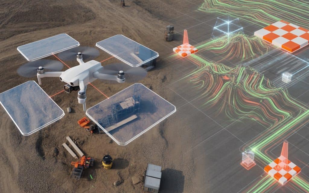
Surveying technology has changed dramatically over the last decade. Projects now move faster, expectations for accuracy are higher, and teams need reliable data sooner than ever. That is why many professionals are turning to a drone photogrammetry survey to capture detailed spatial information quickly. Instead of relying entirely on manual measurements, aerial imagery now plays a major role in modern surveys. Drones capture hundreds of overlapping photos that software converts into maps and 3D models. When the workflow is planned correctly, the results can be extremely accurate. However, achieving consistent results requires more than simply flying a drone and taking photos. Understanding the aerial mapping workflow, using ground control points GCPs, and applying correct survey data processing techniques make all the difference. Let’s explore how you can get your photogrammetry survey right. Why photogrammetry is transforming modern surveying Photogrammetry uses photographs to measure distances, shapes, and elevation. By analyzing overlapping images, software identifies matching features and reconstructs a three dimensional model of the terrain. This method is now widely used in construction, environmental monitoring, mining, and infrastructure planning. One reason for this rapid adoption is efficiency. As per multiple studies, drone based photogrammetry can reduce field survey time significantly compared to traditional surveying methods. Speed alone is not the only advantage. A well executed drone photogrammetry survey also produces highly detailed visual data that teams can use for measurements, progress monitoring, and planning. Understanding the aerial mapping workflow The foundation of successful photogrammetry begins with a structured aerial mapping workflow. Every stage, from planning the flight to processing the images, influences the quality of the final map. The workflow typically begins with planning the survey area and determining flight paths. Drone flight planning software ensures that images overlap correctly and cover the entire site. After the flight, images move into survey data processing software where they are aligned, analyzed, and converted into maps. This workflow might sound simple, but every step affects the final result. Poor flight planning, incorrect altitude, or insufficient image overlap can quickly reduce the accuracy of the entire survey. Why ground control points GCPs matter One of the most important elements of photogrammetry accuracy is the use of ground control points GCPs. These are marked reference points placed across the survey site whose exact coordinates are measured using high precision GPS equipment. When images are processed, these control points help the software align the model with real world coordinates. Without GCPs, photogrammetry models may still look accurate visually but may contain positional errors. Many surveyors consider GCPs essential when producing engineering grade mapping. By anchoring the model to known coordinates, the final dataset becomes far more reliable for planning and design work. The role of RTK drone mapping Another way to improve the reliability of a drone photogrammetry survey is through RTK drone mapping. RTK stands for Real Time Kinematic positioning, a technology that improves the GPS accuracy of the drone itself. With RTK systems, the drone receives correction signals from a base station while flying. These corrections allow the drone to record extremely precise coordinates for each image it captures. Research shows that RTK enabled drone surveys can achieve positional accuracy within 2 to 5 centimeters under proper conditions. This level of accuracy significantly reduces the number of control points required and improves efficiency during field operations. Photogrammetry accuracy tips that make a real difference Even with the best technology available, accuracy still depends on how the survey is conducted. Small adjustments in flight planning and processing can dramatically improve results. Here are several practical photogrammetry accuracy tips that experienced surveyors rely on. Plan sufficient image overlap during the flight mission. Use ground control points whenever engineering level accuracy is required. Maintain consistent altitude and camera angle across the survey. Ensure proper lighting conditions to avoid shadows and distortion. Use reliable software for survey data processing. Following these simple practices ensures your drone photogrammetry survey produces dependable data. Why survey data processing is critical? Capturing aerial imagery is only the beginning of the process. The real transformation happens during survey data processing, where specialized software analyzes thousands of images and converts them into spatial data. During processing, software identifies matching features across multiple images. These matches allow the system to calculate camera positions and reconstruct a detailed point cloud of the surveyed area. From this dataset, the software generates orthomosaic maps, digital surface models, and 3D terrain models. The quality of this stage determines how useful the final output will be. Poor processing choices can introduce distortion or alignment errors. That is why experienced survey teams rely on professional processing workflows. How is photogrammetry used in surveying? Photogrammetry supports a wide range of surveying applications today. Construction companies use it to monitor site progress and calculate material volumes. Engineers rely on aerial maps for infrastructure planning and site design. Environmental scientists also benefit from photogrammetry surveys. They use aerial data to track erosion, monitor vegetation, and study landscape changes over time. If you want to understand how overlapping imagery creates maps in more detail, our previous article on Photogrammetry Mapping explains the process step by step. How accurate is photogrammetry When executed correctly, photogrammetry can achieve impressive accuracy. With proper image overlap, well placed GCPs, and accurate GPS data, survey grade results are achievable. However, accuracy depends on several factors including camera quality, flight planning, and environmental conditions. Dense vegetation or poor lighting can reduce measurement precision. For most construction and planning projects, photogrammetry accuracy is more than sufficient. In situations where dense vegetation obscures the ground surface, LiDAR may provide better elevation results. Is LiDAR or photogrammetry more accurate This question comes up frequently when comparing survey technologies. The answer depends on the type of terrain being mapped. Photogrammetry performs extremely well on open terrain where surfaces are clearly visible. In these environments, aerial imagery produces detailed and visually rich maps. Choosing the right technology for your survey In many projects, the best approach is not choosing one technology over the other. Instead,
How Photogrammetry Builds a Map From Overlapping Photos
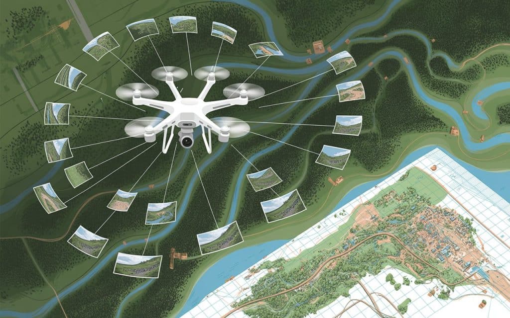
Photogrammetry has revolutionized the way we create detailed maps. By using overlapping aerial images, photogrammetry allows us to convert raw photos into accurate, 3D maps. In this blog, we will explore how photogrammetry mapping works, including the process of orthomosaic creation and image-based mapping, and why overlapping aerial images are critical to achieving precision. When creating a map, the main challenge lies in stitching images together seamlessly. This is where photogrammetric processing and the proper overlap come into play. Let’s dive into how drone mapping workflow and overlapping images come together to build precise, reliable maps. What is Photogrammetry Mapping? Photogrammetry mapping is the process of converting two-dimensional photographs into accurate three-dimensional maps. By taking overlapping aerial images of the terrain, photogrammetry uses software to extract geographic data. These data points are then used to generate a map, model, or digital representation of the area. Drones are commonly used in photogrammetry mapping, capturing high-resolution aerial images from various angles. These images overlap to create accurate 3D models and maps, capturing details that were previously difficult to measure. The process is efficient and non-invasive, allowing for faster data collection and analysis than traditional surveying methods. How Overlapping Aerial Images Improve Mapping Accuracy The key to photogrammetry mapping is the overlapping aerial images captured during flights. These overlapping images are critical for creating a seamless, accurate map. When an image overlaps with another, it provides the software with common reference points that can be aligned and matched to create a cohesive 3D model. The more overlap between images, the better the software can identify features and map the area accurately. In photogrammetry, the term “overlap” refers to the portion of one image that overlaps with the next image in the series. This overlap ensures that the system has multiple perspectives of the same features, which is crucial for precise mapping. What’s The Process of Orthomosaic Creation An orthomosaic creation is a key result of photogrammetry mapping. Once the images are captured and processed, they are stitched together to form a comprehensive, high-resolution map of the area. This map is referred to as an orthomosaic, which is essentially a distortion-free, true-to-scale image of the terrain. The process involves aligning the overlapping images so that every detail from the images matches up. This process is what enables the system to generate accurate, realistic maps. The result is a high-quality map that can be used for further analysis, planning, and even decision-making. Why Overlap is Crucial in Photogrammetry Mapping The Importance of Image Overlap in Photogrammetry Without sufficient overlap, the software would have difficulty matching corresponding points across images. This would lead to gaps, misalignments, or even incomplete data. Proper overlap ensures that each photo aligns correctly with others, creating a consistent model of the area. Having at least 60% overlap between aerial images is the standard in photogrammetry. This ensures there is enough shared data between images for precise mapping. Too little overlap can cause large errors, while too much overlap can result in unnecessary data and increased processing time. Why is Overlap Important in Photogrammetry? Overlap provides redundancy, ensuring that important features are captured from multiple angles. This redundancy is key to creating accurate 3D models, as it compensates for any errors in individual photos. Essentially, the overlap improves the reliability of the entire mapping process, ensuring high-quality results. Understanding Photogrammetric Processing Photogrammetric processing is the backbone of creating a 3D model from overlapping aerial images. Once the photos are captured, the software aligns and processes them to extract important data points. This data is then used to create a 3D point cloud, which is essentially a collection of thousands of points that represent the real-world features of the terrain. The photogrammetric process involves several steps: Image alignment: The software matches corresponding points between images using the overlap. Feature extraction: Important features such as edges, contours, and structures are identified. 3D model generation: Data points are used to generate a 3D model or map of the area. This workflow is highly automated, making it fast and cost-effective, and ensuring accuracy and consistency across the data collected. Learn more: Photogrammetry vs LiDAR: Which One Wins Drone Mapping Workflow: From Capture to Map The drone mapping workflow for photogrammetry involves several stages, from capturing the initial aerial images to generating the final map. Here is how it typically works: Step 1: Image Capture Drones equipped with high-resolution cameras capture aerial images of the area. These images should be taken at regular intervals to ensure overlapping aerial images. Step 2: Image Processing The captured images are processed by photogrammetric software to align them and create a 3D model. The software uses photogrammetric processing to create a point cloud and mesh. Step 3: Map Generation The final product is either a 2D orthophoto or a 3D model that represents the terrain. The map can be used for planning, analysis, and decision-making. Step 4: Data Analysis Once the map is created, it can be analyzed for various purposes such as land use, construction planning, or environmental monitoring. Benefits of Using Photogrammetry in Mapping Photogrammetry mapping offers several benefits that make it ideal for large-scale projects: Cost-effective: It reduces the need for expensive equipment and manual labor. Speed: Drones can capture a large area quickly, significantly reducing the time needed for data collection. Accuracy: With proper overlap, photogrammetry can provide highly detailed and accurate maps. Flexibility: It can be used in a variety of industries, including construction, agriculture, and environmental monitoring. FAQs Why is overlap important in photogrammetry? Overlap ensures that images have common reference points, which allows software to align and create accurate models. Without overlap, photogrammetry cannot produce a seamless map. What is the recommended image overlap for accurate photogrammetry? A 60% overlap is generally recommended to ensure sufficient data for processing. This allows the software to align points from multiple images and create an accurate 3D model. What is the typical forward overlap used in aerial photogrammetry? Typically, 70% forward overlap is used in aerial
LiDAR Scanners Explained: Types, Accuracy & Real-World Applications

If you’ve ever wondered how surveyors, engineers, and architects gather precise 3D models of the world around us, the answer is likely LiDAR scanners. These devices use laser scanning technology to map physical environments in incredible detail. Whether it’s for urban planning, environmental monitoring, or even autonomous driving, LiDAR scanners are becoming an essential tool in many industries. In this blog, we’ll break down what LiDAR scanners are, the different types available, their accuracy, and how they are applied in the real world. What Is a LiDAR Scanner? LiDAR scanners (Light Detection and Ranging) use laser pulses to scan the surface of objects. The laser emits thousands of pulses per second. By measuring how long it takes for the laser pulse to bounce back, the scanner can determine the distance to objects. This data is then used to create detailed 3D models or maps of the scanned area. The beauty of LiDAR scanners is their ability to capture data with high precision. Unlike traditional cameras, LiDAR doesn’t just capture images. It captures the distance to every point, creating an incredibly detailed, three-dimensional representation of the environment. Types of LiDAR Scanners There are several different types of LiDAR scanners, each with unique features that make them suited for specific applications. Here’s a look at the most commonly used types: 1. UAV LiDAR Scanner The UAV LiDAR scanner is a drone-mounted system that has revolutionized surveying, particularly in hard-to-reach areas. By attaching LiDAR sensors to drones, surveyors can collect high-resolution data from the air. This is especially useful for mapping large areas like forests, mountains, or construction sites. The advantage of UAV LiDAR scanners is their ability to capture data quickly, safely, and accurately. Traditional land-based surveys can be slow and expensive, especially in difficult-to-reach areas. Drones equipped with LiDAR scanners can cover vast areas in a fraction of the time, without the need for surveyors to physically access the site. 2. Mobile LiDAR Systems Mobile LiDAR systems are mounted on vehicles, such as cars or trucks, to scan roads, bridges, or even entire cities. As the vehicle moves, the LiDAR sensor continuously collects data, creating a 3D model of the environment it drives through. These systems are commonly used in infrastructure inspections and transportation planning. For example, mobile LiDAR systems are frequently used to map roads, ensuring that engineers have up-to-date information for road maintenance, repairs, and new construction. 3. Airborne LiDAR Airborne LiDAR is mounted on aircraft, such as planes or helicopters, to capture large-scale data from the sky. This type of LiDAR scanner is commonly used for mapping large geographical areas, such as forests, rivers, or entire cities. The airborne LiDAR system can quickly cover vast areas. That is why it’s often used in environmental monitoring, flood risk assessment, and terrain modeling. By collecting data from the air, surveyors can map large-scale landscapes and obtain precise elevation data over wide areas. 4. Terrestrial LiDAR Terrestrial LiDAR scanners are typically used for close-range mapping of smaller, more confined spaces. These systems are often mounted on tripods and operated manually. They are commonly used in architectural design, archaeological surveys, and construction projects. Unlike the other types of LiDAR scanners, terrestrial scanners capture data in a more focused area. This makes them ideal for creating highly detailed, accurate 3D models of buildings or structures. They are often used to create digital replicas of buildings for restoration or to aid in construction planning. LiDAR Scanner Accuracy One of the primary advantages of LiDAR scanners is their high accuracy. LiDAR scanning technology can capture data down to the centimeter level, making it one of the most precise methods of mapping available today. The accuracy of LiDAR scanners depends on several factors, including the type of scanner, the quality of the sensors, and the altitude or distance at which the scanning takes place. For example, UAV LiDAR scanners may offer slightly less accuracy than terrestrial or airborne systems, simply because they are scanning from a greater distance. However, even UAV-based systems can achieve highly accurate results, especially when used in combination with GPS correction systems like RTK (Real-Time Kinematic). Overall, LiDAR scanners provide a level of precision that is unmatched by traditional surveying methods, which rely on measuring distances manually or with total stations. Real-World Applications of LiDAR Scanners LiDAR scanners have a broad range of applications, and their uses are constantly expanding. Below are a few real-world examples of how LiDAR scanners are used today: 1. Urban Planning and Development One of the most common uses for LiDAR scanners is in urban planning. Architects and city planners rely on 3D LiDAR scanning to create accurate models of existing infrastructure and design new developments. The precise 3D data generated by LiDAR scanners helps architects plan buildings, roads, and utilities with greater accuracy. It reduces errors and improves the overall efficiency of projects. LiDAR technology is also used to map and monitor the growth of cities. Mapping by drones can capture up-to-date information about urban sprawl, population density, and land use. It enables cities to plan for future expansion and improvements. 2. Environmental Monitoring LiDAR data BC is extensively used in environmental monitoring. By providing highly detailed terrain maps, LiDAR helps environmental agencies assess the condition of forests, wetlands, and other natural resources. For example, airborne LiDAR is often used to measure tree heights and canopy density, which are important for forestry management. LiDAR data BC can also help track erosion, study coastal areas, and monitor the impact of natural disasters like floods. 3. Agriculture Farmers are using LiDAR scanners to improve crop management and monitor soil conditions. UAV LiDAR scanners can capture detailed data on fields, including the contours of the land and the distribution of water and nutrients. This helps farmers optimize irrigation, reduce waste, and improve crop yields. The precision offered by mobile LiDAR systems and 3D LiDAR scanning also allows farmers to identify areas of the field that need special attention. It specifically targets the areas suffering from drought or pest
Aerial Photography in BC: How Modern UAVs Are Improving Visual Data Capture
Aerial photography BC is now more efficient, accurate, and cost-effective, thanks to the rise of UAVs (unmanned aerial vehicles). These UAV drones are changing how visual data is captured across various industries, from real estate to forestry. Because they enable the collection of high-resolution aerial images and offer valuable insights from above. That too, in Less Time and Less Cost than traditional methods. In this blog post, we’ll discuss how modern UAVs are revolutionizing BC aerial photography, the benefits they offer. We will also touch upon how businesses and industries are using drone photography BC to improve data collection and decision-making. What Is Aerial Photography and Why Is It Important in BC? Aerial photography BC refers to capturing high-resolution images of the land from the air, using drones or other aircraft. In BC, this technology has proven invaluable due to the province’s diverse landscapes, which include urban centers, forests, and mountains. UAVs are now essential tools for capturing detailed imagery of these areas, providing an overall view that would be difficult to achieve with traditional methods. According to a report by Markets and Markets, The Global Drone Services (Drone as a service) Market Size is estimated to reach USD 57.8 billion by 2028. This surge in drone adoption reflects the increasing demand for high-resolution aerial images in industries ranging from real estate to agriculture. In BC, aerial photography BC is used across various sectors, from real estate marketing to environmental monitoring. UAVs are capable of providing precise, high-quality data that allows businesses to make informed decisions and optimize operations. To learn more about how UAVs are transforming industries, check out Rekon Solutions’ previous blog on aerial imagery. How Modern UAVs Are Changing Aerial Photography in BC 1. Cost-Effective and Efficient Data Collection Before UAVs, aerial photography in BC relied heavily on helicopters or small planes, which were costly and required extensive coordination. Today, BC aerial photography has become more accessible due to drones, which offer a far more affordable and efficient way to capture high-quality images. Studies show that drone surveys can shorten project timelines by up to 45% and reduce field costs by 50%. This drastic reduction in costs and time makes drones an attractive solution for industries in BC. 2. Real-Time Data Capture and Analysis One of the most significant benefits of using UAVs for drone photography BC is the ability to capture data in real-time. Drones allow for images and videos to be transmitted back to the operator immediately, enabling them to assess the quality of the footage and make adjustments during the flight. In industries like forestry aerial imaging, where real-time data is crucial, drones allow forestry teams to capture images of large forested areas. They can also quickly analyze the health of the trees or assess potential hazards. This speed of data collection ensures that timely decisions can be made without waiting for data to be processed manually. 3. Access to Hard-to-Reach Areas BC’s rugged terrain, including dense forests and steep mountain ranges, often makes traditional aerial photography methods difficult or even impossible. UAVs have overcome these challenges by providing the ability to capture imagery in hard-to-reach areas, making aerial photography BC more versatile. In the real estate aerial photos sector, drones are used to capture properties in remote locations. These aerial shots provide unique perspectives and enhance property listings by showcasing the surrounding landscape and the property’s proximity to natural attractions, a key selling point for buyers. 4. High-Resolution and Detailed Imagery Modern UAVs are equipped with high-quality cameras capable of capturing high-resolution aerial images. These images provide detailed insights into areas that require precise analysis, such as construction sites, agricultural fields, or forest health. For example, drones with high-definition cameras are able to provide detailed, high-resolution imagery of agricultural fields in BC. This imagery is used to monitor crop health, assess soil quality, and identify pests or diseases that could affect crops. By using this data, farmers can optimize their practices and boost crop yields. 5. Increased Safety and Reduced Risks Traditional methods of aerial photography BC using aircraft or helicopters can be risky, especially when working in difficult or hazardous environments. UAVs, on the other hand, are much safer because they can be operated remotely, eliminating the need for personnel to be in potentially dangerous situations. For instance, in the forestry sector, forestry aerial imaging allows drones to fly over dense forests or steep terrain without putting human operators at risk. This is especially important when assessing areas affected by wildfires, landslides, or other natural disasters, as drones can provide the necessary data without requiring on-site personnel. Applications of UAVs in Aerial Photography in BC 1. Real Estate Marketing In the competitive real estate market, real estate aerial photos are an excellent way to differentiate properties. Drone photography BC provides stunning aerial views of properties, which are crucial for showcasing features such as landscaping and surrounding amenities. These visuals are often used in online listings, promotional materials, and virtual tours. 2. Forestry and Environmental Monitoring One of the most important uses of aerial photography BC is in forestry aerial imaging. UAVs enable forestry professionals to monitor the health of trees, map forest areas, and track changes in vegetation. These insights are crucial for managing BC’s vast forest resources sustainably. Drones are also used to monitor wildlife habitats and assess environmental conditions in BC. By capturing high-resolution aerial images, environmentalists can track changes in ecosystems and assess the impact of climate change or human activities. 3. Construction and Land Development In construction and land development, UAVs provide accurate and detailed data for planning and monitoring projects. Drones can capture high-resolution aerial images of construction sites, which are then used for site analysis, progress tracking, and planning. By using aerial photography BC, developers can ensure that projects remain on schedule and within budget. Drones also help identify any issues on-site, such as safety hazards or errors in design, enabling construction teams to address problems quickly and efficiently. 4. Agricultural Monitoring In BC’s agricultural
Why LiDAR is a Game Changer in Mapping?
Have you ever wondered how LiDAR mapping can reveal hidden details that traditional mapping methods miss? From uncovering buried landscapes to creating precise 3D models of cities and forests, LiDAR (Light Detection and Ranging) is transforming how professionals map and measure the world. In this post, we’ll explore what makes LiDAR mapping such a breakthrough technology, how it compares to other mapping methods like photogrammetry, and why industries across the globe are rapidly adopting it. What is LiDAR Mapping? LiDAR mapping uses laser light to measure distances between a sensor and surrounding objects. Mounted on drones, aircraft, or vehicles, LiDAR systems emit thousands of laser pulses per second, recording the time it takes for each pulse to bounce back. This process generates a “point cloud”, which is a dense 3D dataset that reveals the exact shape of terrain, vegetation, and structures. Unlike standard cameras that capture images in visible light, LiDAR sensors can penetrate vegetation and detect fine changes in elevation. It makes LiDAR mapping indispensable for surveying, construction, mining, and environmental studies. According to research published in Sensors Journal (MDPI), LiDAR-based mapping achieves elevation accuracy within a few centimeters, outperforming most optical methods in both resolution and depth measurement (source). Why LiDAR Mapping is a Game Changer 1. Unmatched Accuracy and Detail The precision of LiDAR mapping lies in its ability to collect millions of data points per second. These points form high-resolution 3D models that allow professionals to analyze terrain in extreme detail. Whether it’s detecting subtle changes in land elevation or calculating exact distances between structures, LiDAR’s accuracy is unparalleled. Even under dense vegetation or low-light conditions, LiDAR continues to deliver reliable measurements. This level of accuracy is especially valuable in floodplain modeling, infrastructure design, and urban planning — where even small errors can lead to costly outcomes. 2. Speed and Efficiency Traditional ground surveys or photogrammetry-based aerial mapping can take days or even weeks to complete, depending on terrain and accessibility. With LiDAR mapping, those same areas can be surveyed in hours. Because LiDAR sensors collect data rapidly and require minimal human intervention, projects that once demanded multiple field visits now only need a single flight. The result? Lower labor costs and faster turnaround times. 3. Ability to See Beneath Vegetation One of LiDAR’s biggest advantages is its ability to “see through” vegetation. The laser pulses penetrate tree canopies, allowing surveyors to capture both the top of the canopy and the ground surface below. This makes mapping an ideal tool for forestry management, archaeology, and environmental monitoring. It reveals the details that traditional imagery simply can’t capture. 4. Versatility Across Industries LiDAR technology isn’t limited to one industry. It’s revolutionizing: Construction and Infrastructure: For topographic surveys, earthwork measurements, and as-built documentation. Mining and Geology: To monitor pit walls, calculate stockpile volumes, and detect slope movements. Environmental Conservation: For mapping forests, monitoring erosion, and managing floodplains. Archaeology: To uncover ancient settlements hidden beneath dense vegetation. Utilities: For inspecting power lines, pipelines, and telecommunication routes with pinpoint precision. 5. Integration with Drone Technology When combined with drones, LiDAR mapping becomes even more powerful. Drone-mounted LiDAR systems can capture high-accuracy data across vast or inaccessible areas while minimizing costs and safety risks. Drones equipped with LiDAR are now being used for everything from highway design to dam inspection. This combination of mobility, automation, and precision makes it one of the most advanced mapping solutions available today. 6. Enhanced Data Quality and 3D Modeling Unlike 2D imagery, LiDAR produces detailed 3D point clouds that can be converted into elevation models, contour maps, and digital twins. These 3D datasets provide engineers and planners with a realistic representation of the site that is essential for accurate simulations and decision-making. Advantages of LiDAR over Photogrammetry While both LiDAR and photogrammetry are valuable for mapping, they differ in accuracy, data type, and environmental adaptability. Feature LiDAR Mapping Photogrammetry Data Type 3D point clouds using laser light 2D/3D images using visible light Accuracy Centimeter-level, even in low light Dependent on lighting and texture Vegetation Penetration Yes No Weather Dependence Minimal High Processing Time Faster Requires more image processing Best For Terrain, vegetation, infrastructure Visual mapping, aesthetic models Simply put, LiDAR mapping provides the level of detail and consistency required for engineering-grade applications, while photogrammetry excels in visual documentation. The Purpose of LiDAR Mapping The primary purpose of LiDAR mapping is to collect high-accuracy spatial data for analysis, planning, and monitoring. It enables professionals to: Generate detailed elevation and terrain models Identify geological hazards Monitor construction progress Plan transportation routes Assess environmental impact Whether mounted on drones, aircraft, or vehicles, LiDAR sensors provide decision-makers with precise data that can guide large-scale projects with confidence. Challenges and Limitations Despite its advantages, LiDAR mapping has some limitations: Cost: LiDAR sensors are more expensive than cameras used for photogrammetry. However, the investment often pays off through accuracy and time savings. Complexity: Processing and managing large LiDAR datasets require technical expertise and computing resources. Surface Reflection: Highly reflective or transparent surfaces (like water or glass) can sometimes interfere with data capture. Still, advancements in sensor design and cloud-based processing are steadily overcoming these challenges, making LiDAR mapping more accessible than ever. The Future of LiDAR Mapping The future of mapping lies in automation and artificial intelligence. Where LiDAR sits at the heart of this evolution. As sensors become lighter and more affordable, LiDAR will play an even bigger role in real-time mapping, self-driving vehicles, and digital twins of entire cities. According to MarketsandMarkets, the global LiDAR mapping industry is projected to surpass USD 5.6 billion by 2030, driven by its growing use in construction, energy, and transportation sectors. Conclusion From uncovering hidden landscapes to enabling precision engineering, LiDAR mapping is redefining how we see and shape our world. Its ability to capture ultra-accurate 3D data, penetrate vegetation, and integrate with drones makes it an indispensable tool for industries that rely on reliable spatial intelligence. If you’re ready to experience the future of mapping, Rekon Solutions offers advanced LiDAR mapping
Why LiDAR Mapping Is the Key to Faster, More Accurate Mining Surveys?

If you’re still using conventional surveying techniques for your mining projects, you might be missing out on a game-changing technology: LiDAR mapping for mining. Traditional methods can be time-consuming, labor-intensive, and prone to inaccuracies. In contrast, LiDAR technology offers a faster, more precise alternative that can revolutionize your surveying processes. What Is LiDAR Mapping for Mining? LiDAR stands for Light Detection and Ranging. It’s a remote sensing technology that uses laser pulses to measure distances and create detailed 3D models of the Earth’s surface. In mining, LiDAR mapping involves scanning the terrain to gather high-resolution data, which is then processed to produce accurate topographic maps and models. This technology is particularly valuable in mining exploration, where understanding the terrain is crucial for planning and decision-making. The Advantages of LiDAR Mapping in Mining Surveys 1. Enhanced Accuracy One of the primary benefits of LiDAR mapping for mining is its exceptional accuracy. Traditional surveying methods can be affected by human error and environmental factors. LiDAR, however, provides precise measurements, even in challenging conditions, ensuring that your data is reliable and trustworthy. 2. Faster Data Collection LiDAR technology allows for rapid data acquisition over large areas. This speed is particularly beneficial in mining site surveying, where time is often a critical factor. With LiDAR, you can complete surveys in a fraction of the time it would take using traditional methods, leading to faster project timelines and reduced costs. 3. Improved Safety Mining operations often involve hazardous environments. By using LiDAR mapping, you can minimize the need for personnel to enter dangerous areas. Drones equipped with LiDAR sensors can safely capture data from above, reducing the risk to human workers. 4. Detailed Terrain Modelling LiDAR provides detailed 3D models of the terrain, allowing for comprehensive analysis. These models can be used to assess slope stability, calculate volumes of stockpiles, and plan excavation activities with greater precision. 5. Effective Monitoring Regular LiDAR surveys enable continuous monitoring of mining sites. This ongoing assessment helps in detecting changes in the terrain, identifying potential issues early, and ensuring that operations are proceeding as planned. LiDAR in Mining Exploration In the early stages of mining exploration, understanding the landscape is crucial. LiDAR technology aids in identifying geological features, such as faults and mineral deposits, which might not be visible on the surface. This information is invaluable for planning drilling activities and assessing the viability of mining projects. How to Read LiDAR Maps Interpreting LiDAR data requires specialized knowledge. The resulting point clouds and 3D models need to be processed and analyzed using appropriate software. Professionals trained in LiDAR data processing can extract meaningful information, such as elevation changes and surface features, to make informed decisions. LiDAR Scanning Technology in Mining Modern LiDAR systems are equipped with advanced scanning technology that enables high-resolution data capture. These systems can be mounted on various platforms, including drones, vehicles, and even handheld devices, providing flexibility in data collection across different mining environments. LiDAR Survey Cost vs. Traditional Methods While the initial investment in LiDAR equipment may be higher than traditional surveying tools, the long-term benefits outweigh the costs. The speed and accuracy of LiDAR mapping can lead to significant savings by reducing the time spent on surveys and minimizing errors that could lead to costly mistakes. Case Studies: LiDAR Success in Mining Several mining operations have successfully integrated LiDAR technology into their surveying processes: Open-Pit Mining: LiDAR-equipped UAVs have been used to create detailed 3D models of open-pit mines, improving volume calculations and slope analysis Geospatial. Underground Mining: Autonomous robots equipped with LiDAR sensors have mapped underground mine environments, enhancing safety and operational efficiency arxiv.org. Government Initiatives: In Maharashtra, India, drone-based LiDAR surveys are being used to monitor mining activities, curb illegal mining, and boost revenue The Times of India. Conclusion Adopting LiDAR mapping for mining is no longer just an option; it’s becoming a necessity for modern mining operations. The technology offers unparalleled accuracy, speed, and safety, transforming how mining surveys are conducted. If you’re looking to enhance your surveying processes and stay ahead in the industry, integrating LiDAR technology is a step in the right direction. If you’re interested in leveraging LiDAR technology for your mining projects, Rekon offers advanced LiDAR surveying services tailored to your needs. Contact us today to learn more about how we can assist you in achieving precise and efficient mining surveys. Frequently Asked Questions (FAQs) What is the main advantage of using LiDAR in surveying? LiDAR provides high-precision data collection over large areas in a short amount of time, improving accuracy and efficiency compared to traditional methods. What is the accuracy of LiDAR surveys? LiDAR surveys can achieve accuracy levels of 1-3 centimeters, depending on the equipment and conditions. How is LiDAR used in mining? LiDAR is used in mining for creating detailed 3D models of terrains, volume calculations, slope analysis, and monitoring environmental changes. What factors can influence the accuracy of LiDAR measurements? Factors such as equipment quality, environmental conditions, and the method of data collection can affect the accuracy of LiDAR measurements.
How Indoor Drones at Nuclear Sites Reduce Radiation Exposure?

Ever wondered how inspectors stay safe in radioactive environments? Nuclear facilities are essential for energy production but come with inherent risks. One of the most pressing concerns is radiation exposure during routine inspections. Traditional methods often require personnel to enter hazardous zones, increasing their exposure. But what if there was a way to gather critical data without stepping into these dangerous areas? Enter indoor drones for nuclear sites. These specialized drones are revolutionizing how inspections are conducted in radioactive environments, ensuring safety while maintaining efficiency. What Are Indoor Drones for Nuclear Sites? Indoor drones for nuclear sites are unmanned aerial vehicles (UAVs) designed to navigate confined, GPS-denied spaces within nuclear facilities. Equipped with advanced sensors and cameras, these drones can perform detailed inspections in areas that are otherwise inaccessible or too dangerous for human workers. 1. Minimizing Human Radiation Exposure The primary advantage of using indoor drones is the significant reduction in human exposure to radiation. By deploying drones into potentially hazardous areas, inspectors can gather necessary data without entering these zones themselves. This approach aligns with the ALARA (As Low As Reasonably Achievable) principle, which aims to minimize radiation exposure to workers. For instance, the Flyability Elios 3 drone, a leading indoor inspection drone, is designed to operate in confined spaces, capturing high-resolution images and videos without the need for human presence in the area. 2. Enhanced Inspection Capabilities Indoor drones are not just about safety; they also offer enhanced inspection capabilities. Many of these drones are equipped with LiDAR sensors, enabling them to create detailed 3D maps of the inspected areas. This technology allows for precise measurements and the identification of potential issues that might be missed during manual inspections. The integration of LiDAR technology with drones, such as the Elios 3 RAD, provides real-time data collection, which is crucial for timely decision-making in nuclear facilities. 3. Access to Confined and Hazardous Spaces Nuclear facilities often contain areas that are difficult to access due to their design or the presence of hazardous materials. Indoor drones for nuclear sites are specifically designed to navigate these challenging environments. Their compact size and maneuverability allow them to enter tight spaces, such as reactor cores or storage tanks, to perform inspections without compromising safety. For example, drones can be used to inspect the interiors of nuclear reactors, identifying signs of wear or potential failures that could lead to safety concerns. 4. Real-Time Data Collection and Analysis One of the significant benefits of using indoor drones is the ability to collect real-time data. Equipped with high-definition cameras and sensors, these drones transmit live footage and measurements back to operators, allowing for immediate analysis. This capability enables prompt identification of issues and facilitates quicker decision-making processes. The integration of radiation sensors with drones further enhances this capability, providing immediate readings of radiation levels in various parts of the facility. 5. Cost-Effectiveness and Efficiency While the initial investment in indoor drones for nuclear sites may be substantial, the long-term benefits outweigh the costs. By reducing the need for human entry into hazardous areas, these drones minimize the risk of accidents and potential health issues, leading to lower insurance and compensation costs. Moreover, drones can perform inspections more quickly and efficiently than traditional methods, reducing downtime and increasing the overall productivity of the facility. Rekon Solutions: Leading the Way in Indoor Drone Inspections At Rekon Solutions, we specialize in providing innovative drone inspection services tailored to the unique challenges of nuclear facilities. Our team of experts utilizes state-of-the-art indoor drones equipped with advanced LiDAR and imaging technologies to deliver precise, real-time data while ensuring the safety of personnel. Whether it’s conducting routine inspections, assessing structural integrity, or monitoring radiation levels, Rekon Solutions is committed to helping nuclear facilities operate safely and efficiently. Conclusion Indoor drones for nuclear sites are transforming the landscape of nuclear facility inspections. By minimizing radiation exposure, enhancing inspection capabilities, accessing confined spaces, and providing real-time data, these drones are becoming indispensable tools in ensuring the safety and efficiency of nuclear operations. If you’re looking to implement indoor drone technology in your nuclear facility, consider partnering with Rekon Solutions. Our expertise in drone technology and commitment to safety can help you integrate these innovative tools into your operations seamlessly.
How Does Aerial Mapping Improve the Accuracy of Construction Planning?

Ever Wondered How Construction Projects Stay on Track? Construction planning involves numerous factors, from terrain analysis to resource allocation. Every decision requires accurate data to avoid costly mistakes. Traditional methods of land surveying can be time-consuming and prone to human error. But what if there was a faster, more reliable way to capture the terrain and ensure that every detail is accounted for? That’s where aerial mapping in construction comes into play. This advanced technology is transforming how construction professionals plan and execute projects, improving accuracy and efficiency from start to finish. What Is Aerial Mapping in Construction? Aerial mapping in construction uses drones equipped with cameras, LiDAR sensors, and GPS technology to capture detailed, high-resolution images of the terrain. These drones fly over the construction site, gathering data that’s then processed into 2D maps or 3D models. This data provides a precise, up-to-date representation of the land, which is essential for accurate construction planning. Unlike traditional land surveying, which often requires manual measurements and on-the-ground inspections, aerial mapping is automated, making the process faster and less prone to errors. The resulting maps and models help construction teams make informed decisions that can significantly impact the success of a project. How Aerial Mapping Improves Accuracy in Construction Planning? 1. Provides Real-Time, High-Resolution Data Traditional surveying methods can take weeks to complete, especially for large projects. With aerial mapping in construction, you can gather high-resolution data in a fraction of the time. Drones can cover vast areas in a single flight, providing real-time data that’s immediately available for analysis. This helps construction teams make quick, accurate decisions without delays or guesswork. For example, instead of waiting for weeks for land survey reports, you can get detailed 3D models and orthophotos almost immediately. This allows for faster project initiation and smoother progress throughout the project lifecycle. 2. Captures Complex Terrain Features with Precision Construction sites often involve varied and complex terrains, such as slopes, bodies of water, or uneven ground. Traditional surveying methods might miss critical features or fail to capture them with the necessary precision. Aerial mapping in construction eliminates this risk. Drones equipped with LiDAR sensors or high-definition cameras can capture even the smallest details, such as changes in elevation, natural obstacles, and man-made structures. These precise measurements help construction teams assess the land’s suitability for the intended project and make accurate site plans. 3. Reduces Human Error One of the most significant advantages of aerial mapping in construction is the reduction in human error. Traditional surveys require manual measurements, which are subject to mistakes, miscalculations, or overlooking key features. With drones, the process is automated, and data is collected with incredible precision. The data gathered through aerial mapping is processed using specialized software, ensuring that the information is accurate and up-to-date. This technology minimizes the potential for errors and ensures that all features are captured with high precision, improving the reliability of your construction plans. 4. Allows for Detailed Topographic Mapping Topographic maps are essential for construction planning, as they show the elevations and contours of the land. Inaccurate topographic data can lead to costly mistakes, such as poor drainage planning, unsuitable foundation placement, or improper grading. Drones equipped with LiDAR sensors are especially useful for creating detailed topographic maps. These maps provide accurate elevation data, which is crucial for planning roads, foundations, and other structural elements. With aerial mapping in construction, you can create high-quality topographic maps that help construction teams plan with confidence. 5. Improves Collaboration and Communication In large construction projects, collaboration between teams is essential. Traditional survey data often gets lost in translation or takes time to share across different departments. With aerial mapping in construction, all stakeholders—architects, engineers, and contractors—can access the same high-quality data in real time. The ability to view and manipulate 3D models and maps allows for better communication, fewer misunderstandings, and more accurate planning. Stakeholders can collaborate efficiently, addressing potential issues early in the project and avoiding delays or rework. Applications of Aerial Mapping in Construction Projects 1. Site Planning and Design Before construction begins, accurate mapping is critical for planning and designing the site. Aerial mapping in construction provides the detailed information needed to design structures, roads, and utilities. Construction teams can use 3D models to visualize the entire project and make adjustments before breaking ground. 2. Monitoring Construction Progress Aerial mapping is not limited to the planning phase—it can also be used throughout the construction process to monitor progress. Drones can fly over the site at regular intervals to capture updated images and data. This allows project managers to compare the current state of the project to the initial plans, ensuring that everything is on track. 3. Resource Management Construction projects involve numerous resources, from materials to equipment and labor. Accurate mapping helps construction teams plan the placement of resources efficiently. Aerial mapping in construction allows teams to optimize the layout of the site, reducing waste and improving workflow. 4. Risk Assessment and Mitigation Identifying potential risks early in the project is crucial for preventing delays and accidents. Aerial mapping helps construction teams assess the land for hazards such as unstable soil, flood zones, or nearby environmental concerns. By identifying these risks in advance, teams can make better decisions about site preparation and mitigation strategies. Conclusion Aerial mapping in construction is transforming the way construction teams plan, execute, and monitor projects. By providing accurate, real-time data, reducing human error, and improving collaboration, aerial mapping ensures that construction projects are completed on time, within budget, and with greater precision. At Rekon, we specialize in providing cutting-edge aerial mapping solutions tailored to the needs of your construction projects. Whether you’re planning a small development or a large-scale infrastructure project, our advanced drone technology and expertise can help you gather the data you need to make informed decisions and achieve better outcomes.
