LiDAR: The Game-Changer for Topographic Accuracy
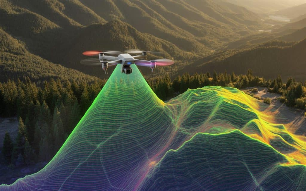
Imagine you’re tasked with creating a highly detailed topographic map of a rugged landscape. If you’re relying on traditional surveying methods, the process is slow, expensive, and prone to errors. But, what if you could complete the task in a fraction of the time, with incredible precision, and without risking safety? That’s where LiDAR accuracy in surveying comes in. LiDAR (Light Detection and Ranging) has revolutionized how we measure and map the earth’s surface. With the power of survey-grade LiDAR, precision LiDAR data, and high-accuracy mapping, this technology has taken topographic surveying to new heights—literally. In this post, we’ll explain why LiDAR is the go-to tool for modern topographic solutions and how it’s reshaping surveying for industries. Let’s dive into how LiDAR elevation accuracy can work for you. What is LiDAR and How Does It Improve Topographic Accuracy? LiDAR is a remote sensing technology that uses laser light to measure distances. By emitting thousands of laser pulses per second, LiDAR can collect precise measurements of the surface below. It is possible even through dense vegetation or hard-to-reach areas. These pulses bounce off the earth’s surface, and the data captured is processed into a 3D model of the terrain. Unlike traditional surveying methods, LiDAR delivers much higher accuracy and efficiency. LiDAR accuracy in surveying is unmatched, especially in environments that are challenging for manual surveying. Whether it’s dense forests or uneven terrains, LiDAR’s ability to penetrate obstacles provides a true representation of the land’s topography. The Impact of LiDAR on Topographic Surveying Traditional topographic surveys rely on a lot of manual data collection and calculations. That’s why surveyors often need to travel long distances, set up instruments at multiple locations, and rely on human judgment for measurements. This process can be time-consuming, labor-intensive, and, unfortunately, prone to errors. With LiDAR, surveyors can capture high-density, high-accuracy data across vast areas quickly and efficiently. Where LiDAR’s precision and high-accuracy mapping capabilities reduce human error significantly. Not only does this save time and costs, but it also leads to more reliable, detailed, and consistent data. In fact, a research paper on Improvement of Lidar Data Accuracy Using Lidar-Specific Ground Targets proves that LiDAR can achieve an accuracy level of up to 2- 3 cm under perfect conditions. This level of precision is a game-changer when it comes to creating topographic maps that are truly representative of the land. LiDAR Accuracy vs Traditional Surveying Methods When you compare LiDAR elevation accuracy with traditional survey methods, the differences are stark. LiDAR surveys provide much more detailed and precise measurements, especially in complex areas. For instance, when it comes to mapping floodplains or mountainous regions, LiDAR can easily capture elevation changes in minute detail that would be hard to identify with manual methods. Additionally, LiDAR surveys cover large areas much faster than traditional surveys. Where a traditional survey might take weeks to complete, a LiDAR survey can be finished in a matter of days, saving time and resources. Moreover, survey-grade LiDAR systems can cover thousands of acres in a single flight, capturing data over both natural and man-made features with high precision. The sheer speed and accuracy of LiDAR technology make it an essential tool for industries like construction, forestry, and environmental monitoring. LiDAR is providing topographic solutions that simply weren’t possible with conventional surveying methods. Learn more: Drone Inspection Services: Improving Safety, Accuracy & Cost Efficiency Applications of LiDAR in Modern Topographic Solutions LiDAR has numerous applications across various industries, but it’s especially valuable in modern topographic solutions. Let’s look at a few key areas where LiDAR has truly made an impact: 1. Mapping and Infrastructure Planning LiDAR’s ability to capture precise 3D data makes it ideal for infrastructure planning, including road construction, utilities, and urban development. By providing accurate elevation data, LiDAR enables engineers to design with confidence, ensuring structures are built on stable, well-planned terrain. 2. Environmental Monitoring LiDAR plays a critical role in monitoring landscapes for environmental protection and resource management. It helps track vegetation changes, measure forest biomass, and even monitor water levels in flood-prone areas. 3. Mining and Resource Extraction LiDAR is used extensively in the mining industry to survey land and assess mineral deposits. Its ability to map large areas with precision helps in optimizing resource extraction processes while minimizing environmental impact. 4. Agriculture and Land Management LiDAR is also becoming an essential tool for precision agriculture. By providing accurate data on elevation, water drainage, and soil erosion, farmers can make better decisions about land use and crop management. LiDAR vs Traditional Surveying: Which One Wins? In the debate of LiDAR vs traditional methods, it’s clear that LiDAR offers superior benefits in terms of precision, speed, and cost-effectiveness. Here’s a quick comparison of both methods: Feature Traditional Surveying LiDAR Data Accuracy Prone to human error High precision (up to 2 cm) Speed Slow, labor-intensive Fast, covering large areas quickly Cost Higher due to labor and equipment Lower operational costs for large areas Terrain Access Difficult in rugged or dense areas Easily penetrates dense vegetation As you can see, LiDAR is the clear winner for large-scale, complex topographic surveys. Its ability to quickly and accurately capture high-quality data far surpasses the capabilities of traditional surveying methods. Learn more: LiDAR vs. Traditional Methods: The Power of Precision in Mapping Surveying LiDAR Technology: A Future-Proof Solution The surveying industry continues to evolve, and LiDAR is leading the way. With advancements in sensor technology, precision LiDAR data is becoming even more accurate, efficient, and accessible. More and more industries are adopting LiDAR elevation accuracy for their surveying needs. Whether it’s for flood risk mapping, large-scale infrastructure projects, or environmental monitoring, LiDAR provides the high-precision data needed to make better decisions. As the technology continues to improve, we can expect even more innovative uses of LiDAR in surveying and mapping. It is poised to play a critical role in shaping the future of topographic surveying and other industries. Frequently Asked Questions (FAQs) Why is overlap important in LiDAR? Overlap ensures accurate point cloud generation
Drone Inspection Services Improving Safety Accuracy and Cost Efficiency
Across industries, inspection services are becoming more challenging every year. Assets are aging, sites are expanding, and safety expectations are rising fast. As a result, traditional inspection approaches are no longer enough for you. They are slow, risky, and often expensive to execute. This is why many organizations are now rethinking how inspections should be done. Drone inspection services are changing how you inspect critical assets. They provide a safer, faster, and more reliable alternative to manual methods. Most importantly, they help you make confident decisions using accurate data. Have you ever wondered how inspections can improve safety and efficiency together? Or why drones are becoming common across inspection workflows. Let’s explore how this approach benefits you directly. What is drone inspection? Drone inspection refers to using unmanned aerial systems to inspect assets remotely. Instead of climbing structures or entering confined spaces, drones capture the required visuals. This allows inspections without physical access or operational disruption. High resolution cameras collect detailed imagery from multiple angles. In many cases, sensors also gather measurement data for further analysis. Together, this creates a complete inspection record you can rely on. This method removes many traditional inspection limitations. It also improves access to hard to reach locations. That alone changes how you plan inspections. Why are inspection methods evolving? Inspections today involve more complexity than ever before. Infrastructure is larger, environments are harsher, and timelines are tighter. Meanwhile, downtime has become increasingly costly for you. Traditional inspections often require heavy equipment and large teams. They may disrupt operations and expose workers to safety risks. As a result, inspections can be delayed or scaled back. 4 Ways Drone Inspection is Better Than Traditional Methods In comparison, drone inspection services address these challenges directly. They allow inspections to happen faster and more safely. This supports better planning and fewer interruptions. 1. Improved safety during inspections Safety is one of the strongest reasons organizations adopt drones. Inspectors no longer need to work at heights or enter unstable areas. This significantly reduces exposure to hazards. Drones perform inspections from a safe distance. Fewer people are required on site during inspections. Consequently, workplace incidents and liability risks decrease. Over time, safer inspections strengthen your safety culture. They also improve confidence among teams and stakeholders. That is a meaningful benefit for you. 2. Accuracy that supports better decisions Accurate data is essential for effective inspections. Drones capture consistent imagery using repeatable flight paths. This minimizes errors caused by human limitations. Each inspection creates a reliable visual record. You can compare results across inspection cycles easily. This helps identify changes and emerging issues early. A professional drone inspection service ensures data consistency. That consistency supports better maintenance decisions. It also improves long term asset planning. 3. Enhanced efficiency and reduced inspection time Efficiency is another major advantage you will notice quickly. Drone inspections take hours instead of days. Large areas can be covered in a single flight. Automated workflows streamline data collection and processing. This reduces the need for repeated site visits. You receive actionable insights faster. By using drones, inspections fit better into schedules. Projects move forward with fewer delays. This efficiency saves both time and resources. 4. Cost efficiency across inspection projects Inspection costs can rise quickly using traditional methods. Equipment rentals, labor, and shutdowns increase expenses. Weather delays can add even more costs. Drone inspection services reduce many of these expenses. Fewer personnel are needed on site. Inspections are also completed faster. Although drones require upfront investment, long term savings are clear. Lower operational costs appear over repeated inspections. This makes drone inspections cost effective for you. Common uses across industries Today, UAV inspection services are used across many sectors. Utilities rely on drones to inspect power lines and towers. Transportation teams use them for bridges and rail networks. Construction projects benefit from regular progress inspections. Mining and energy operators monitor assets in remote locations. Environmental teams track changes without disturbing sites. Each industry benefits from safer access and accurate data. This flexibility makes drones suitable for many inspection needs. It expands how you monitor assets. 1. Infrastructure inspections by drone Infrastructure inspections by drone focus on large critical structures. These include bridges, towers, pipelines, and road networks. Many of these assets are difficult to access manually. Drones inspect infrastructure without closures or shutdowns. They capture detailed visuals from multiple perspectives. You gain insights while operations continue. This approach improves inspection coverage and safety. It also reduces public disruption. That is valuable for large scale projects. 2. Industrial drone inspections in action Industrial drone inspections are ideal for complex facilities. Plants, tanks, and stacks often present serious safety challenges. Traditional inspections may require shutdowns or confined entry. Drones inspect these environments quickly and remotely. They collect visuals without interrupting production. This minimizes downtime and operational impact. For industrial operators, this is a major improvement. Inspections become routine instead of disruptive. Safety standards remain high. 3. Asset monitoring drones for long term insights Asset monitoring drones support ongoing condition tracking. Regular flights create visual records over time. You can compare current and past conditions easily. This helps identify gradual changes before failures occur. Maintenance can be planned proactively. Unexpected repairs are reduced. With asset monitoring drones, inspections become strategic. They support long term planning instead of reactive responses. This adds measurable value to your operations. Connecting inspection and mapping insights Inspection data often complements surveying data. If you read our previous blog on UAV drone surveying accuracy, you will notice this connection. Both rely on aerial data for informed decisions. Similarly, our aerial mapping blog explains how visuals support planning. Together, these approaches provide a complete asset view. This helps you understand conditions more clearly. Choosing the right inspection partner Technology alone does not guarantee quality results. Experience in flight planning and data interpretation matters. You need insights, not just images. A reliable drone inspection service understands your inspection goals. They tailor workflows to your assets and risks. This ensures data is useful and actionable. Working with the
Aerial Photography by Drone Applications Beyond Marketing & Media
Across industries, visual data is becoming critical for smarter decision making. Projects are expanding. Environments are complex. And expectations for accuracy keep rising. As a result, traditional photography methods are no longer giving you the full picture. Aerial photography by drone offers a new way to see sites, assets, and environments clearly. It provides high resolution visuals that support planning, monitoring, and operational confidence. Instead of relying on limited ground views, you gain perspectives that reveal what truly matters. Many teams already use drone imagery beyond marketing and media. They rely on it to improve safety, reduce guesswork, and support technical decisions. So, if you want visuals that work harder for your projects, this approach deserves your attention. What is aerial photography by drone? Aerial photography by drone uses unmanned aircraft to capture images from above. These drones are equipped with advanced cameras and stabilization systems. This allows you to collect clear visuals from multiple angles safely. Unlike traditional aerial photography, drones operate at lower altitudes. This produces sharper details and more precise imagery. You gain accuracy without relying on aircraft or heavy equipment. The process is flexible and efficient for many environments. Flights can be planned quickly and adjusted when conditions change. That adaptability makes drone photography practical for you. Why aerial imagery is evolving beyond marketing? For years, aerial visuals were mainly used for promotion. They focused on branding, campaigns, and media content. Today, visual data supports real operational needs. Industries now depend on visuals for planning and verification. Accurate imagery helps teams assess conditions and progress. This shift has expanded how aerial visuals are used. Drone aerial photography removes many access limitations. It delivers consistent visuals without physical entry. That makes it valuable for technical and industrial projects. Key advantages of drone based aerial photography Drone imagery offers benefits beyond visual appeal. It improves access, accuracy, and efficiency across projects. These advantages directly support better outcomes for you. 1. Get high resolution visuals you can rely on High-resolution drone images capture fine details clearly. Surface conditions, textures, and edges remain visible. This level of detail supports technical review. Clear imagery reduces uncertainty during assessments. You can zoom in without losing clarity. That makes evaluations more reliable for you. When visuals are used for reporting, quality matters. High resolution images prevent misinterpretation. They help communicate findings confidently. 2. Supports planning and site assessment Aerial imagery plays a key role during early planning stages. You can assess terrain, access routes, and surroundings. This supports better preparation before work begins. Drone imagery provides complete site context. It shows how structures relate to the environment. That perspective is difficult to capture from the ground. By using aerial photography by drone, planning becomes informed. Decisions rely on real visuals instead of assumptions. This reduces risk for your projects. 3. Helps with industrial aerial photography Industrial aerial photography supports operational and technical needs. Facilities often include elevated or restricted areas. Manual access to these areas can be risky. Drones capture visuals without disrupting operations. This minimizes downtime while maintaining visibility. You gain insights without interrupting workflows. In industrial environments, documentation is essential. Drone imagery provides consistent visual records. This helps track changes and conditions over time. 4. Monitors progress and asset conditions Progress monitoring requires consistent visual reference points. Drone imagery captures the same views repeatedly. This makes comparisons easy and reliable. Asset condition monitoring benefits from regular imagery. You can identify wear, damage, or changes early. This supports proactive maintenance planning. With aerial photography by drone, monitoring becomes structured. Visual data supports long term asset management. Unexpected issues are reduced significantly. 5. Improves safety through remote visuals Safety remains a major benefit of drone imagery. Drones remove the need for working at heights. They also reduce exposure to hazardous areas. Remote visuals allow assessments from a safe distance. Fewer people are required on site. This lowers overall safety risks for you. Over time, safer workflows improve confidence. Teams rely on visuals instead of physical access. That benefits everyone involved. 6. Efficient and time saving solution Drone imagery significantly reduces data collection time. Large areas can be captured quickly. This helps keep projects on schedule. Traditional photography may take days to complete. Drones accomplish the same task in hours. That efficiency matters when timelines are tight. By using UAV photography services, workflows stay efficient. Faster visuals support quicker decisions. Productivity improves across teams. Can you integrate imagery with other data? Aerial imagery often complements mapping and surveying data. If you read our previous blog on UAV mapping for industrial inspection, you will see this connection. Because the visuals enhance spatial understanding for you. Imagery also supports documentation and reporting. Clear visuals make technical data easier to interpret. This improves communication across stakeholders. When imagery is combined with other datasets, insights improve. You gain a more complete site understanding. That supports informed decisions. Choosing the right photography approach Not all aerial photography solutions deliver the same value. Experience in flight planning and capture matters. Quality depends on execution, not equipment alone. UAV photography services should align with your objectives. Image resolution and coverage must suit your needs. This ensures visuals remain useful. A professional approach delivers consistent outcomes. It turns images into decision making tools. That is where real value lies. Rekon approach to aerial photography At Rekon Solutions, aerial photography is planned around operational requirements. The focus stays on accuracy, clarity, and usable visuals. This ensures imagery supports real world decisions. The future of aerial photography by drone Drone photography continues to evolve rapidly. Camera technology is improving and automation is increasing. Image quality will continue advancing. As adoption grows, applications will expand further. Industries will rely more on visual data. This technology is becoming essential for you. Aerial photography by drone is no longer optional. It is a practical operational tool. Its role will continue growing. Frequently asked questions What is aerial photography by drone? Aerial photography by drone captures images using unmanned aircraft. It provides elevated views without manual access.
LiDAR in British Columbia: Use Cases, Accuracy & Regulatory Considerations
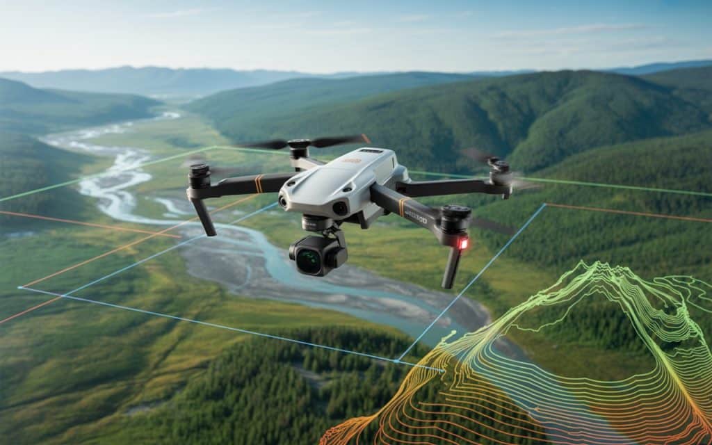
In British Columbia, land surveying is essential. But it’s not always easy. Because the landscape is vast and varied. And, for years, traditional methods worked well, but things are changing lately. Where LiDAR BC is making surveying faster, safer, and more accurate. Have you ever wondered how LiDAR mapping BC works or why it’s becoming so popular? Let’s dive in and see why this technology is now a game-changer for professionals across the province. What Is LiDAR and How Does It Work? LiDAR BC is a technology that uses laser pulses to measure distances. These pulses bounce off objects, and the sensor measures how long it takes for them to return. This allows drones or aircraft to create detailed, accurate 3D models of the land. The data can be processed into digital terrain models, surface maps, and 3D models. It’s like having a bird’s-eye view of the terrain, but with incredible detail. Why Is LiDAR BC So Important? 1. Superior Accuracy for Terrain Mapping BC Accuracy is key when it comes to land surveys. LiDAR BC provides measurements down to the centimeter level. This is especially important in BC, where the landscape can change quickly. LiDAR mapping BC allows surveyors to capture every small detail. Whether it’s trees, buildings, or land contours, it gives a precise picture of the area. That’s not something traditional methods can always offer. 2. Wide Range of Applications LiDAR BC isn’t just for one type of project. It’s versatile. From BC LiDAR surveys to forestry management, this technology helps in many industries. In forestry, it’s used to measure tree height and canopy density. In construction, it maps land before development. For environmental monitoring, it tracks changes in terrain and vegetation. Whether it’s for planning or monitoring, LiDAR data BC can do it all. 3. Faster Data Collection One of the biggest perks of airborne LiDAR BC is how quickly data can be collected. Traditional surveying can take days or even weeks, depending on the area. With drones or planes, LiDAR BC can cover large areas in just hours. The speed is a huge advantage. More data in less time means quicker decisions. It’s a game-changer for projects that need to keep moving forward. 4. Non-Intrusive Data Collection Unlike traditional methods, LiDAR BC doesn’t require surveyors to walk or climb dangerous terrain. Drones or aircraft do the heavy lifting. This makes it safer. LiDAR mapping allows data collection from the sky without disturbing the environment. No need to cut down trees or navigate hazardous terrain. It’s all done from the air. 5. Cost-Effective The initial investment in LiDAR BC might seem steep, but the return is worth it. Traditional surveying requires heavy equipment and a lot of man-hours. Drones and UAV land surveys cut down on both. Fewer people need to be on-site. Less machinery is required. This efficiency leads to big savings over time, even though drones and LiDAR data BC may require an upfront cost. Regulatory Considerations When Using LiDAR BC 1. Environmental and Land Use Regulations In BC, land use is tightly regulated. For anyone using LiDAR, it’s important to follow these rules. Whether you’re using airborne LiDAR to monitor a forest or a construction site, there are environmental considerations. LiDAR mapping BC is commonly used for environmental assessments. But it must comply with provincial and federal regulations. The goal is to make sure the technology is used responsibly while minimizing its impact on natural habitats. Permits may be required before conducting a survey. 2. Privacy and Legal Concerns LiDAR may collect data over large areas, which can raise privacy concerns. When surveying near populated areas or private property, it’s essential to follow privacy laws. In BC, drone operations must comply with the Canadian Aviation Regulations. These include restrictions on where and when drones can fly. It’s important to get the necessary permissions and inform local authorities, especially when flying over private property or sensitive areas. 3. Permitting for Airborne LiDAR BC Using drones for LiDAR often requires permits. When flying over public or private land, specific guidelines must be followed. Operators must stay within controlled airspace and avoid no-fly zones. The drones must also be registered with Transport Canada if they are to be used for commercial purposes. Regulatory compliance ensures that operations are safe and legal. It also helps maintain the integrity of the data being collected. The Future of LiDAR BC The demand for LiDAR is growing. As more industries recognize its value, LiDAR mapping BC is becoming a go-to tool for surveying and monitoring. Advancements in drone technology, combined with improved sensors, are making LiDAR even more accessible and effective. More businesses in BC are beginning to see the benefits, from quicker surveys to safer, more accurate data. In the future, LiDAR data BC will be more widely adopted. Its versatility will allow even more industries to harness its power. The technology is poised to be the standard for industries that rely on high-quality surveying data. Rekon Solutions: Your LiDAR Partner in BC At Rekon Solutions, we offer LiDAR BC services designed to meet the unique needs of various industries. Our team uses state-of-the-art technology to deliver high-precision data that helps businesses make informed decisions. We specialize in airborne LiDAR for accurate LiDAR surveys and terrain mapping. Our drones collect data efficiently, ensuring you get the best results in less time. Contact us today to learn how we can help with your next LiDAR mapping BC project. We’re here to help you gather the most accurate, reliable data for your operations. Check out our blog on UAV surveying to learn more about how drones are revolutionizing data collection in various industries. Conclusion LiDAR has quickly become an essential tool for land surveying in British Columbia. From its ability to provide precise data to its versatility across industries, LiDAR mapping is transforming how professionals approach surveying and land analysis. Whether you’re in construction, forestry, or environmental management, LiDAR data provides you with the insights needed to plan, execute, and monitor
The Power of Drone LiDAR for Surveying Large Areas
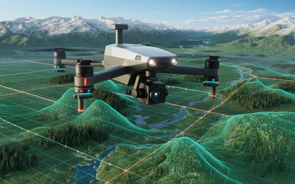
In the world of modern surveying, Drone LiDAR for surveying has become a game-changer. These powerful machines allow surveyors to gather highly accurate topographic data over vast areas in a fraction of the time it would take using traditional methods. Whether you’re working in construction, environmental conservation, or infrastructure development, the benefits of using Drone LiDAR for surveying are undeniable. In this blog, we’ll explore how Drone LiDAR for surveying can revolutionize your approach to large-scale projects, making data collection faster, more precise, and cost-effective. What is Drone LiDAR Surveying? Drone LiDAR for surveying refers to the use of drone-mounted LiDAR (Light Detection and Ranging) sensors to scan and map the earth’s surface. Unlike traditional survey methods, which can be slow and often require physical access to challenging areas, LiDAR technology works more efficiently. It uses laser pulses to gather detailed data about the topography and other features of the land. The drone’s mobility allows it to cover large areas quickly, even in hard-to-reach places like rugged terrain, forests, or flooded regions. LiDAR drones combine the flexibility of unmanned aerial vehicles (UAVs) with the precision of LiDAR technology, offering a new level of surveying capability. The best LiDAR drone for surveying can produce high-resolution 3D models that are invaluable for decision-making in industries such as construction, mining, agriculture, and more. Get in touch if you want to learn how Rekon achieves it for you. Why Use a Drone LiDAR for Surveying? 1. Precision and Accuracy One of the most significant advantages of using a Drone LiDAR for surveying is the unmatched accuracy it offers. LiDAR sensors can measure distances with incredible precision, often down to a few centimeters. This level of detail is essential for projects that require highly accurate data, such as environmental monitoring, flood risk mapping, and infrastructure planning. 2. Speed and Efficiency Surveying large areas traditionally can take weeks or even months, depending on the terrain. However, with Drone LiDAR for surveying, surveyors can collect vast amounts of data in a fraction of the time. For example, while a traditional crew might need several weeks to survey a few hundred acres, a Drone LiDAR for surveying can do the same job in just a few days. 3. Cost-Effective The upfront cost of Drone LiDAR for surveying may seem high, but the long-term savings are significant. By reducing the amount of manual labor required and speeding up data collection, LiDAR drones help minimize overall project costs. Furthermore, the ability to access hard-to-reach areas without the need for expensive machinery or safety measures adds even more savings. 4. Remote Access Surveying in areas that are difficult to reach — like mountains, dense forests, or flood zones — can be dangerous and time-consuming. A Drone LiDAR for surveying can fly over such areas, capturing accurate data without putting surveyors at risk. This is especially valuable for projects that take place in hazardous environments, such as construction near cliffs or floodplain management. 5. Comprehensive Data Collection A Drone LiDAR for surveying can provide highly detailed 3D models, topographic maps, and digital elevation models (DEMs) that give surveyors a complete view of the land. And these models can be used for planning, analysis, and monitoring, offering invaluable insights for decision-making. The Best LiDAR Drone for Surveying: Why Rekon Solutions Stands Out When it comes to finding the best LiDAR drone for surveying, Rekon Solutions provides cutting-edge drones equipped with the latest LiDAR technology. Our drones are designed to deliver unparalleled precision, efficiency, and cost-effectiveness for your surveying needs. Rekon drones are particularly suited for industries such as: Mining and Exploration: LiDAR drones are crucial for mapping and analyzing mineral resources, helping mining companies make informed decisions about where to dig and how to optimize their operations. Construction: Whether you’re developing infrastructure or working on property development, LiDAR drones provide accurate data that enhances the planning and design processes. Environmental Conservation: LiDAR technology plays a key role in monitoring ecosystems, managing floodplains, and identifying erosion hotspots. Government and Infrastructure Projects: LiDAR drones provide invaluable data for urban planning, flood risk management, and other essential infrastructure developments. With Rekon Solutions, you not only get a Drone LiDAR for surveying but also gain access to expert consultation, real-time data collection, and actionable insights that improve project outcomes. What are the Costs Associated with Drone LiDAR Surveying? LiDAR Drone Price The price of LiDAR drones for surveying varies based on the technology, sensors, and features included. While the initial investment may seem significant, the benefits in speed, precision, and cost savings often outweigh the upfront costs. Drone Topographic Survey Cost The cost of a drone topographic survey depends on the size of the area to be surveyed and the complexity of the terrain. While traditional methods can incur high labor and equipment costs, LiDAR drones can reduce these expenses by providing more efficient and accurate data. LiDAR Drone Rental For those who only need a drone for a one-off project, LiDAR drone rental is a viable option. Renting a drone for a specific survey can save costs without the need for a long-term investment. Rekon Solutions offers affordable LiDAR drone rental services for short-term projects. How Drone LiDAR Drones are Revolutionizing Surveying Drone LiDAR for surveying are not just changing how surveyors work; they’re transforming entire industries. By reducing the time and costs associated with traditional surveying methods, LiDAR drones make it possible to complete complex projects faster and with greater accuracy. This transformation is especially evident in industries such as construction, where LiDAR drones are used to monitor progress, detect issues, and optimize resource allocation. The technology also offers advanced features like real-time data processing and integrated GPS systems, allowing surveyors to gather high-quality data without the need for post-processing. As the technology evolves, we can expect even more powerful capabilities, such as enhanced sensor integration and improved data accuracy. Final Verdict The ability to survey large areas with precision, speed, and cost-effectiveness is what sets Drone LiDAR for surveying apart from traditional methods.
