LiDAR vs. Traditional Methods: The Power of Precision in Mapping
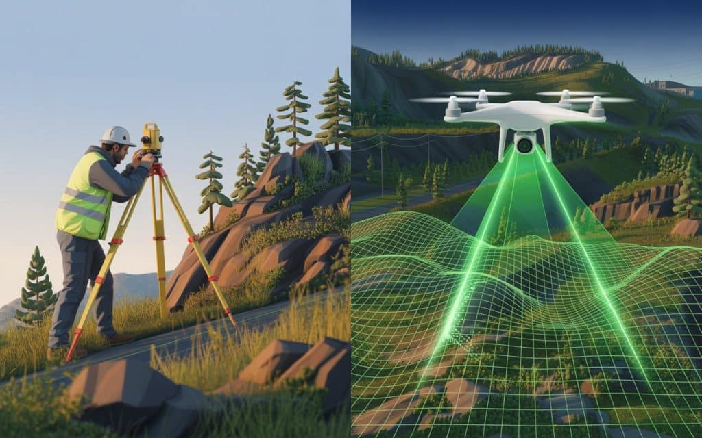
When it comes to mapping and surveying, precision is paramount. Traditional methods have been relied upon for centuries, but times are changing. LiDAR technology has emerged as a game-changer, offering high-accuracy results faster and more efficiently than ever before. In fact, recent 2024 research proves and supports LiDAR’s efficiency and accuracy in complex and vegetated terrains. While conventional land surveying still holds value, LiDAR is quickly becoming the preferred method. Thus, understanding the key differences between LiDAR and traditional methods helps you make informed decisions for your projects. Let’s dive into how LiDAR survey accuracy can transform your mapping and surveying efforts. LiDAR vs Traditional Methods: Key Differences LiDAR (Light Detection and Ranging) uses laser pulses to capture highly accurate measurements of the Earth’s surface. In contrast, traditional methods rely on physical measurement tools such as tape measures, levels, and theodolites. Here’s how the two compare: Traditional Surveying: Manual Measurement: Requires more physical presence and effort from surveyors. Slower Process: Measurements are taken step-by-step, making the process time-consuming. Human Error: Dependent on surveyor skill, which can lead to inaccuracies. LiDAR Surveying: Remote Data Capture: Uses laser sensors, which can quickly map vast areas without physically being there. Faster Data Collection: LiDAR scans large surfaces in a fraction of the time compared to manual methods. Higher Accuracy: Laser technology ensures a high-precision output, minimizing the risk of human error. Benefits of LiDAR Over Conventional Land Surveying LiDAR is revolutionizing the surveying industry by offering clear advantages over traditional methods. Let’s break down the key benefits of LiDAR survey accuracy: Speed and Efficiency LiDAR captures data much faster than traditional methods. A large area can be scanned in a short period, reducing fieldwork time and increasing productivity. Accuracy LiDAR’s precision is unmatched, capturing millimeter-level measurements. Traditional methods, while accurate, are prone to small errors due to manual measurements. Safety LiDAR allows surveyors to map hazardous or hard-to-reach areas without putting themselves at risk. This makes it ideal for environments such as cliffs, mines, and remote locations. How LiDAR Improves Mapping Technology Evolution As the need for faster and more reliable data grows, LiDAR’s role in mapping technology evolution cannot be overstated. Traditional surveying is often limited by time constraints, accuracy issues, and the need for manual labor. LiDAR, on the other hand, is enhancing the capabilities of modern surveying in several ways: 3D Mapping LiDAR creates detailed 3D models that show elevation changes and surface characteristics. Whereas, traditional methods are typically limited to 2D data or require complex processes to generate 3D data. High-Precision Mapping LiDAR’s high precision captures surface details with extreme accuracy, even for complex terrain. High-precision mapping becomes possible, leading to more reliable decision-making for urban planning, construction, and other industries. Real-Time Data LiDAR’s ability to process data quickly provides near-real-time results, allowing faster project planning and execution. In comparison, traditional methods are more time-intensive, often leading to delays in projects. LiDAR vs Traditional Methods: Which One is Right for Your Project? While LiDAR offers clear advantages in terms of speed, precision, and safety, traditional methods still have their place. It’s important to understand when LiDAR is the best choice, and when conventional surveying might still be applicable. When to Use LiDAR: For large-scale surveying projects requiring high precision. For difficult-to-access or dangerous terrain. For projects requiring 3D models, such as flood modeling or forest management. When to Use Traditional Surveying: For smaller, simpler projects where speed and precision are not as critical. When budget constraints prevent the use of LiDAR technology. For projects where historical methods are well-suited and adequate for the task. The Future of Surveying: LiDAR and Modern Surveying Methods Looking ahead, modern surveying methods will increasingly rely on LiDAR technology. As the technology evolves and becomes more accessible, the applications for LiDAR will expand. LiDAR not only makes surveying faster and more accurate, but it also opens doors to previously impossible projects. The integration of LiDAR with UAVs (drones) is particularly exciting, as it allows surveyors to capture data from hard-to-reach areas without the need for scaffolding or helicopters. This is a game-changer in industries like construction, mining, and environmental monitoring. Learn more: LiDAR in British Columbia: Use Cases, Accuracy & Regulatory Considerations Advantages of High-Precision Mapping with LiDAR When high-precision mapping is required, LiDAR is the clear winner. The level of detail LiDAR provides cannot be matched by traditional surveying methods. Here are some of the advantages of LiDAR for high-precision mapping: Accurate to the millimeter: Provides measurements with high vertical and horizontal accuracy. Faster data collection: Allows for faster project execution, which leads to cost savings. Versatile: LiDAR can be used in a variety of industries for different types of mapping needs. Frequently Asked Questions (FAQs) What’s more accurate, LiDAR or photogrammetry? LiDAR is generally more accurate than photogrammetry, especially for capturing elevation data. While photogrammetry excels in visual modeling, LiDAR provides precise, reliable measurements for terrain. What’s better than LiDAR? Nothing is definitively better than LiDAR for terrain mapping, but a combination of LiDAR and photogrammetry can provide both high precision and visual detail. Each technology complements the other, depending on the project needs. Is photogrammetry cheaper than LiDAR? Yes, photogrammetry is generally cheaper than LiDAR, especially for small-scale projects. However, for large and complex projects, LiDAR’s precision and efficiency may justify the higher cost. Is photogrammetry reliable? Photogrammetry is reliable when environmental conditions are ideal. However, it can struggle with accuracy in poor lighting or difficult terrain. LiDAR tends to be more consistent across all conditions. Moving Forward with Confidence Understanding the strengths and limitations of both LiDAR and traditional surveying methods helps you make the best choice for your project. LiDAR’s precision, speed, and ability to map complex terrain make it an invaluable tool for modern surveying. If you are ready to adopt cutting-edge surveying technology, get a quote here or contact our team to learn more about how LiDAR can transform your projects.
Photogrammetry vs LiDAR: Which One Wins

Choosing the right mapping technology can shape the success of your project. Whether you are working in forestry infrastructure construction or mining, the photogrammetry vs lidar debate comes up again and again. Both methods deliver powerful spatial data, but they work very differently and serve different needs. We believe that understanding how each technology performs in real conditions will help you best to make an informed decision. What is Photogrammetry? Photogrammetry is a mapping method that creates 3D models using overlapping images. These images are typically captured by drones or aircraft and processed through software to reconstruct surfaces and structures. This approach works best when there is clear visibility of the ground or objects being mapped. As it relies heavily on light texture and surface detail to calculate depth and shape. Photogrammetry is widely used in construction planning site monitoring and visual inspections. Because it produces highly detailed visuals that are easy to interpret and share with stakeholders. However, its accuracy depends on lighting conditions, surface contrast and line of sight. As the dense vegetation shadows or uniform surfaces can greatly reduce reliability. Learn about Aerial Photography. What is LiDAR? LiDAR uses laser pulses to measure distances between the sensor and the ground. A LiDAR system sends thousands of laser points per second and records how long it takes for each pulse to return. This technology excels in complex environments. It can penetrate vegetation gaps and capture elevation data beneath forest canopies. That capability makes it especially valuable in forestry infrastructure corridors and terrain analysis. Drone based LiDAR systems are commonly used across Canada where large forested areas, uneven terrain and remote access are common challenges. LiDAR data is less dependent on lighting conditions and delivers consistent results even in low contrast environments. Key differences in data capture The core difference in photogrammetry vs lidar lies in how data is collected. Photogrammetry depends on visible light and surface features. If the camera cannot see the ground clearly the data quality drops. LiDAR directly measures distance using laser pulses. Even when the ground is partially hidden by vegetation the system can still collect elevation points. This difference becomes critical in mapping technology comparison scenarios involving forests, powerline corridors, highways and floodplain studies. Accuracy in real world projects When discussing lidar vs photogrammetry accuracy context matters. Photogrammetry can achieve high accuracy on open sites such as construction zones, stockpiles and building exteriors. With proper ground control it performs well for volume calculations and surface modeling. LiDAR delivers superior vertical accuracy in complex terrain. It is particularly effective for slope analysis, drainage planning and infrastructure design in uneven or vegetated areas. In Canadian forestry projects LiDAR is often preferred because it provides reliable elevation models without requiring land clearing or seasonal leaf off conditions. Learn more about the growing demand of LiDAR services. Performance in forestry applications Forestry is where drone lidar vs photogrammetry differences are most visible. Photogrammetry struggles in dense forests because tree canopies block visibility of the ground. This limits its usefulness for terrain modeling and forest inventory analysis. LiDAR can capture multiple returns from a single laser pulse. Some pulses reach the forest floor while others reflect off branches and leaves. This allows accurate ground models, tree height measurements and biomass estimates. For forest management, environmental assessment and infrastructure routing through wooded regions LiDAR consistently delivers more actionable data. Infrastructure and construction use cases In infrastructure and construction both technologies play valuable roles. Photogrammetry is excellent for visual documentation, progress tracking and communication. Construction teams often use it to generate orthomosaics and realistic 3D site models. LiDAR is preferred when precision matters more than visuals. Road design, rail corridors, bridge planning and flood risk analysis benefit from LiDAR accuracy and consistency. Survey technology differences become especially important when working near slopes, waterways or existing utilities where elevation errors can cause costly issues. Cost considerations and project scale Cost is often part of the decision. Photogrammetry systems are generally less expensive to deploy. Data processing is faster and equipment costs are lower. This makes photogrammetry attractive for smaller projects with clear visibility. LiDAR systems involve higher upfront costs and more complex processing. However for large scale projects the value of accurate terrain data often outweighs the investment. In remote Canadian regions where repeat site visits are difficult LiDAR can reduce long term costs by minimizing rework and uncertainty. 3D mapping methods compared When comparing 3D mapping methods it helps to focus on outcomes rather than technology labels. If your goal is realistic visuals, stakeholder presentations or surface level measurements, photogrammetry performs well. If your goal is reliable elevation data, terrain modeling or analysis beneath vegetation LiDAR provides stronger results. Many organizations now combine both methods to leverage the strengths of each depending on project phase and requirements. Which one really wins – Photogrammetry or LiDAR So which one wins in the photogrammetry vs lidar debate? There is no universal winner. The best choice depends on terrain vegetation accuracy needs and project objectives. For forestry infrastructure and large scale land analysis LiDAR often delivers more dependable results. For construction visualization and open site mapping photogrammetry remains a powerful and efficient tool. Working with experienced professionals helps ensure the right technology is applied at the right time. Rekon Solutions supports projects across Canada by helping clients select mapping approaches that align with real conditions and regulatory requirements. Get in touch to discuss your project needs and we’ll show you which solution is best fit for you. FAQs What’s more accurate LiDAR or photogrammetry? LiDAR generally offers higher vertical accuracy especially in vegetated or uneven terrain. Photogrammetry can be very accurate on open sites with good visibility. What’s better than LiDAR? No technology is universally better. In some construction and visualization tasks photogrammetry may be more practical and cost effective than LiDAR. Is photogrammetry cheaper than LiDAR? Photogrammetry is usually more affordable due to lower equipment and processing costs. However, total project value should be considered not just initial cost. Is photogrammetry
Why UAV Drones for Surveying Are Becoming an Industry Standard
Have you ever wondered how land surveys are done so quickly and accurately? The secret lies in UAV drones for surveying. These drones are changing the way surveying is done, making it faster, safer, and more accurate. In this blog, we’ll explore why UAV drones for surveying are now the industry standard. We’ll dive into the benefits, how they work, and why industries are turning to them for land surveys. What Are UAV Drones for Surveying? UAV drones for surveying are unmanned aerial vehicles used to gather land data. These drones are equipped with high-resolution cameras, LiDAR sensors, and GPS systems. They can quickly collect accurate data from the air. The data captured by the drones is used to create detailed maps, 3D models, and digital terrain models. These models help in planning and decision-making for construction, agriculture, and other industries. Why Are UAV Drones for Surveying So Popular? 1. Faster Data Collection One of the biggest reasons for the rise of UAV drones for surveying is speed. Traditional methods took a lot of time. Surveyors had to walk the land, take measurements, and record data manually. This process was slow and labor-intensive. With drones, large areas can be surveyed in a fraction of the time. This means projects get started sooner and finish faster. 2. Higher Accuracy Accuracy is key in surveying. UAV drones for surveying use advanced GPS systems like RTK (Real-Time Kinematic) to capture data with centimeter-level precision. For example, a UAV land survey using RTK technology can produce highly accurate topographic maps. This level of precision is crucial for projects that require exact measurements. 3. Cost-Effective While drones might seem expensive at first, they save money in the long run. Traditional methods require a lot of labor and expensive equipment. Drones, on the other hand, reduce the need for large teams and costly machinery. They also reduce the amount of time spent collecting data. Faster surveys mean fewer labor costs and faster project timelines. 4. Improved Safety Surveying often requires workers to enter hazardous areas. Climbing tall structures, crossing unstable land, or working in difficult conditions can be risky. With UAV drones for surveying, most of the work can be done from the ground. Drones fly over difficult or dangerous terrain, keeping workers out of harm’s way. This makes surveying safer and reduces the risk of accidents. 5. Versatility in Applications UAV drones for surveying are used across many industries. Construction, agriculture, mining, and environmental monitoring all benefit from drone surveys. Drones can map construction sites, monitor crops, and inspect infrastructure. For example, drone surveying applications like GIS drone mapping help farmers monitor crops. They can track soil conditions and assess irrigation needs. This makes farming more efficient and precise. 6. Real-Time Data Collection One major benefit of drone survey technology is real-time data collection. Traditional surveys often required teams to wait days or weeks to analyze the data. Drones, however, provide immediate results. Surveyors can see the collected data almost instantly. This allows for quick decision-making and reduces delays in projects. 7. Easier Repeat Surveys Another advantage is that drones make it easy to repeat surveys. For example, in large construction projects, drones can be used regularly to monitor progress. If there’s a change in the site, drones can be sent out again to capture fresh data. This makes it easy to track progress and stay on schedule without hassle. How UAV Drones for Surveying Work UAV drones for surveying work by flying over the land to capture data. The drone uses high-quality sensors, cameras, and GPS to gather the required data. The data collected is then processed by software to create detailed maps and models. These models can show terrain features, vegetation, roads, and structures. In UAV land mapping, drones capture images that overlap to create a seamless map. This ensures there are no gaps in the data, and surveyors get a complete picture of the area. Why Are UAV Drones for Surveying the Industry Standard? 1. Real-Time Accuracy When it comes to surveying, having accurate data is critical. UAV survey drones provide high-precision measurements. This level of accuracy is why they are so popular in industries like construction and agriculture. RTK drone survey technology improves the accuracy of GPS systems. It ensures that the survey data is correct down to the centimeter. 2. Improved Data Processing Drones make it easy to process data and generate reports. After a flight, the data collected by UAV drones for surveying is processed by software. The software quickly transforms the data into digital maps and 3D models. This saves time and helps surveyors make better decisions faster. 3. Reduces Human Error Human error can happen during traditional surveys, especially when taking manual measurements. Drones, however, remove much of this risk. Surveying with drones eliminates human error in data collection. Drones automatically collect the necessary data, ensuring that measurements are precise and reliable. This results in more accurate maps and models, which is essential for planning projects. 4. Time-Saving Benefits Surveyors no longer need to spend days or weeks gathering data. Drones collect the information much faster and allow for quicker analysis. With traditional methods, surveyors often have to wait for lab results or field reports. Drones provide instant results, so teams can move forward without delays. Industries Benefiting from UAV Drones for Surveying 1. Construction In the construction industry, UAV drones for surveying are essential for mapping large construction sites. Drones help track construction progress and ensure that designs are followed accurately. They are also used to measure stockpiles and monitor earthworks. By using drone surveying applications, construction teams can get precise data and avoid mistakes. This helps keep projects on schedule and within budget. 2. Agriculture Farmers use UAV drones for surveying to monitor crops, track soil health, and measure irrigation. Drones can fly over large fields, collecting data on crop health and environmental conditions. The data is used to make better farming decisions, which can lead to higher yields and reduced waste. 3. Mining
A Complete Guide to Drone LiDAR When You Should Choose LiDAR Over Photogrammetry
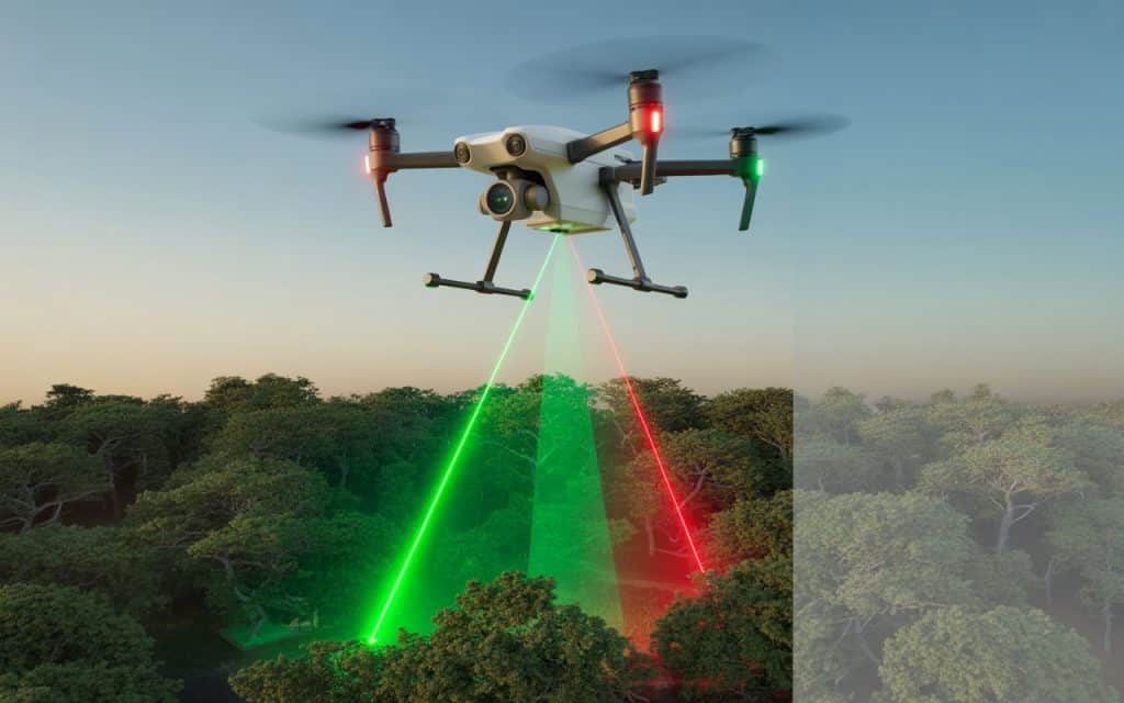
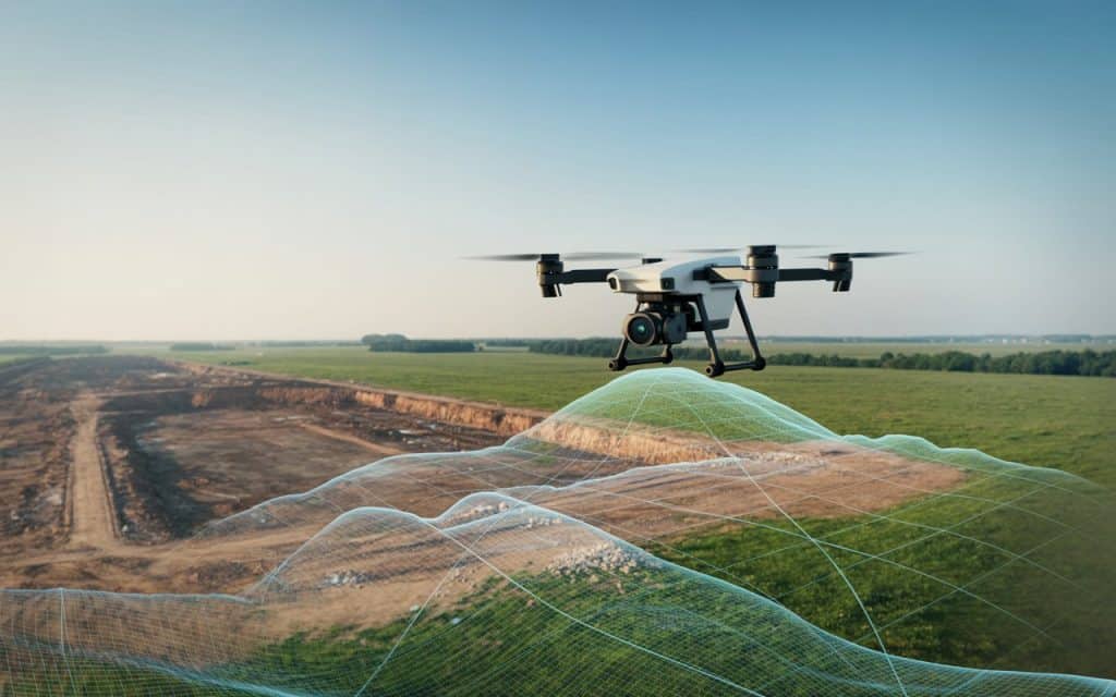
Have you ever wondered which technology works best for your aerial survey? In the world of topographic data collection there are two powerful tools that often come up in conversations: photogrammetry and LiDAR. Both have their strengths. Yet when it really matters you need to know exactly when to choose one over the other. That is why understanding drone lidar and how it compares to photogrammetry. In this guide we will break down the key differences between these technologies and explain when drone lidar is the better choice. We will also look at real use cases and help you understand how to decide between lidar mapping and photogrammetry for your specific needs. What is Drone LiDAR Drone lidar stands for light detection and ranging when applied on unmanned aerial vehicles. It uses laser scanners to measure distances between the aircraft and the ground. For Lidar mapping, thousands of laser pulses are emitted every second. As these pulses hit the surface the time it takes for them to return to the sensor is recorded. This allows the system to build extremely accurate three dimensional data of the terrain and objects on it. The result of lithium based scanning is a detailed point cloud that reveals variations in surface elevation structure and shape with high fidelity. This makes lidar scanners ideal for applications that demand precision. How Lidar Mapping Works To capture lidar data a drone carries a lidar sensor above the area of interest. Where the sensor emits laser pulses while inertial measurement units and GPS records the orientation and position of the scanner. Once the flight is complete the collected data points are processed to produce a dense three dimensional model of the environment. This processed data is ideal for generating bare earth models terrain contours vegetation analysis and other outputs needed in many industries. Because lidar sees through vegetation and captures accurate ground returns it often produces more reliable elevation data than image based methods. Lidar vs Photogrammetry What is the Difference At a high level both lidar and photogrammetry create representations of the surface. Yet they use very different sensing methods. Photogrammetry uses overlapping images to reconstruct three dimensional surfaces from two dimensional photos. It identifies common points in multiple images and uses those to build a reconstructed model. Lidar on the other hand uses active laser scanning to directly measure distances. This means lidar does not rely on visual features to create accurate depth information. This difference is important and it is one of the reasons you sometimes choose lidar over photogrammetry. When You Should Choose LiDAR Over Photogrammetry Vegetated or Forested Terrain One of the clearest cases for choosing lidar mapping is when your survey area includes dense vegetation. Lidar pulses can penetrate gaps in foliage and reach the ground beneath. This allows you to capture accurate ground elevation even under heavy canopy. Photogrammetry often struggles here because images taken from above are blocked by leaves, branches and thick vegetation. The result can be a surface model that floats above the true ground rather than representing it. Complex Topography and Steep Slopes If your project area includes steep slopes, cliffs or rugged terrain, lidar can capture accurate elevation values without distortion. This is because lidar records direct distance measurements for each point. In contrast, photogrammetry may produce artifacts or less accurate elevation data in steep areas because the angles of image capture can warp the reconstructed surface. Projects Requiring High Precision Elevations Some projects require centimeter level precision in their data. Applications like infrastructure design, floodplain modelling and mining surveys often depend on this level of accuracy. Lidar scanners deliver high resolution vertical and horizontal measurements that are hard to replicate with image based methods. In cases where precision is mandatory, lidar becomes the sensible choice. Under Low Light or Poor Visibility Conditions Because lidar uses active laser light it can capture data even when lighting conditions are not ideal. Early morning low sun shadows, dust or cloud cover do not impede laser pulses as much as they affect daylight based imaging. If your survey windows include conditions where clear images are hard to capture, lidar maintains consistent returns. Use Cases for UAV LiDAR Applications Infrastructure Planning and Road Design Infrastructure projects often require accurate surface models to plan roads, bridges and utilities. Lidar mapping provides highly detailed topographic maps that support design and engineering workflows. This can be critical when small elevation differences matter in drainage planning or alignment. Floodplain Analysis and Risk Assessment When modelling areas that might flood or erode lidar provides accurate ground models that help engineers understand water flow and gradients. This is especially important in regions where vegetation obscures the ground. Forest and Vegetation Studies In ecological and forestry work lidar can be used to measure canopy height biomass and structure. Because the laser pulses capture returns at multiple heights lidar provides detailed vertical information that photos cannot deliver. Mining and Earthworks Planning and monitoring excavation sites requires precise volume calculations and surface data. Lidar survey data gives mining professionals the accuracy and repeatability they need when comparing change over time. Lidar Survey BC and Local Context If your project is based in British Columbia or similar regions with rugged terrain and dense forests a lidar survey BC approach can save time and improve accuracy. These landscapes are challenging for photogrammetry alone and benefit from the robust nature of lidar scanning. When Photogrammetry Might Be Sufficient Photogrammetry remains a powerful tool in many scenarios. It works well when: The surface is mostly bare and unobstructed Visual textures are needed High resolution imagery is important for documentation Project budgets are tight and lidar precision is not necessary In these cases photogrammetry survey outputs can be detailed and visually rich. Yet for applications where elevation precision and ground penetration are crucial, lidar still holds the advantage. Combining Lidar and Photogrammetry In many large projects both methods are used together. Lidar provides the accurate ground model while photogrammetry supplies high resolution imagery
Why LiDAR is a Game Changer in Mapping?
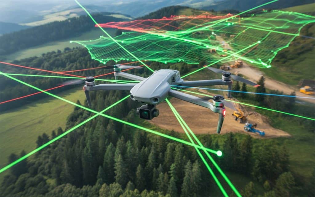
Have you ever wondered how LiDAR mapping can reveal hidden details that traditional mapping methods miss? From uncovering buried landscapes to creating precise 3D models of cities and forests, LiDAR (Light Detection and Ranging) is transforming how professionals map and measure the world. In this post, we’ll explore what makes LiDAR mapping such a breakthrough technology, how it compares to other mapping methods like photogrammetry, and why industries across the globe are rapidly adopting it. What is LiDAR Mapping? LiDAR mapping uses laser light to measure distances between a sensor and surrounding objects. Mounted on drones, aircraft, or vehicles, LiDAR systems emit thousands of laser pulses per second, recording the time it takes for each pulse to bounce back. This process generates a “point cloud”, which is a dense 3D dataset that reveals the exact shape of terrain, vegetation, and structures. Unlike standard cameras that capture images in visible light, LiDAR sensors can penetrate vegetation and detect fine changes in elevation. It makes LiDAR mapping indispensable for surveying, construction, mining, and environmental studies. According to research published in Sensors Journal (MDPI), LiDAR-based mapping achieves elevation accuracy within a few centimeters, outperforming most optical methods in both resolution and depth measurement (source). Why LiDAR Mapping is a Game Changer 1. Unmatched Accuracy and Detail The precision of LiDAR mapping lies in its ability to collect millions of data points per second. These points form high-resolution 3D models that allow professionals to analyze terrain in extreme detail. Whether it’s detecting subtle changes in land elevation or calculating exact distances between structures, LiDAR’s accuracy is unparalleled. Even under dense vegetation or low-light conditions, LiDAR continues to deliver reliable measurements. This level of accuracy is especially valuable in floodplain modeling, infrastructure design, and urban planning — where even small errors can lead to costly outcomes. 2. Speed and Efficiency Traditional ground surveys or photogrammetry-based aerial mapping can take days or even weeks to complete, depending on terrain and accessibility. With LiDAR mapping, those same areas can be surveyed in hours. Because LiDAR sensors collect data rapidly and require minimal human intervention, projects that once demanded multiple field visits now only need a single flight. The result? Lower labor costs and faster turnaround times. 3. Ability to See Beneath Vegetation One of LiDAR’s biggest advantages is its ability to “see through” vegetation. The laser pulses penetrate tree canopies, allowing surveyors to capture both the top of the canopy and the ground surface below. This makes mapping an ideal tool for forestry management, archaeology, and environmental monitoring. It reveals the details that traditional imagery simply can’t capture. 4. Versatility Across Industries LiDAR technology isn’t limited to one industry. It’s revolutionizing: Construction and Infrastructure: For topographic surveys, earthwork measurements, and as-built documentation. Mining and Geology: To monitor pit walls, calculate stockpile volumes, and detect slope movements. Environmental Conservation: For mapping forests, monitoring erosion, and managing floodplains. Archaeology: To uncover ancient settlements hidden beneath dense vegetation. Utilities: For inspecting power lines, pipelines, and telecommunication routes with pinpoint precision. 5. Integration with Drone Technology When combined with drones, LiDAR mapping becomes even more powerful. Drone-mounted LiDAR systems can capture high-accuracy data across vast or inaccessible areas while minimizing costs and safety risks. Drones equipped with LiDAR are now being used for everything from highway design to dam inspection. This combination of mobility, automation, and precision makes it one of the most advanced mapping solutions available today. 6. Enhanced Data Quality and 3D Modeling Unlike 2D imagery, LiDAR produces detailed 3D point clouds that can be converted into elevation models, contour maps, and digital twins. These 3D datasets provide engineers and planners with a realistic representation of the site that is essential for accurate simulations and decision-making. Advantages of LiDAR over Photogrammetry While both LiDAR and photogrammetry are valuable for mapping, they differ in accuracy, data type, and environmental adaptability. Feature LiDAR Mapping Photogrammetry Data Type 3D point clouds using laser light 2D/3D images using visible light Accuracy Centimeter-level, even in low light Dependent on lighting and texture Vegetation Penetration Yes No Weather Dependence Minimal High Processing Time Faster Requires more image processing Best For Terrain, vegetation, infrastructure Visual mapping, aesthetic models Simply put, LiDAR mapping provides the level of detail and consistency required for engineering-grade applications, while photogrammetry excels in visual documentation. The Purpose of LiDAR Mapping The primary purpose of LiDAR mapping is to collect high-accuracy spatial data for analysis, planning, and monitoring. It enables professionals to: Generate detailed elevation and terrain models Identify geological hazards Monitor construction progress Plan transportation routes Assess environmental impact Whether mounted on drones, aircraft, or vehicles, LiDAR sensors provide decision-makers with precise data that can guide large-scale projects with confidence. Challenges and Limitations Despite its advantages, LiDAR mapping has some limitations: Cost: LiDAR sensors are more expensive than cameras used for photogrammetry. However, the investment often pays off through accuracy and time savings. Complexity: Processing and managing large LiDAR datasets require technical expertise and computing resources. Surface Reflection: Highly reflective or transparent surfaces (like water or glass) can sometimes interfere with data capture. Still, advancements in sensor design and cloud-based processing are steadily overcoming these challenges, making LiDAR mapping more accessible than ever. The Future of LiDAR Mapping The future of mapping lies in automation and artificial intelligence. Where LiDAR sits at the heart of this evolution. As sensors become lighter and more affordable, LiDAR will play an even bigger role in real-time mapping, self-driving vehicles, and digital twins of entire cities. According to MarketsandMarkets, the global LiDAR mapping industry is projected to surpass USD 5.6 billion by 2030, driven by its growing use in construction, energy, and transportation sectors. Conclusion From uncovering hidden landscapes to enabling precision engineering, LiDAR mapping is redefining how we see and shape our world. Its ability to capture ultra-accurate 3D data, penetrate vegetation, and integrate with drones makes it an indispensable tool for industries that rely on reliable spatial intelligence. If you’re ready to experience the future of mapping, Rekon Solutions offers advanced LiDAR mapping