Have you ever wondered how developers manage massive land projects with speed, accuracy and confidence?
Large scale land development comes with complexity, including vast areas, uneven terrain, tight deadlines, high financial risk.
Where one wrong assumption about elevation drainage or boundaries can lead to costly delays.
This is where photogrammetry is changing everything.
Because photogrammetry allows you to capture real world environments with precision using images taken from above.
And when it’s applied correctly, it turns land development from a guessing game into a data driven process. Consequently, it helps you plan better, build smarter and move faster.
What Photogrammetry Means for Modern Land Development
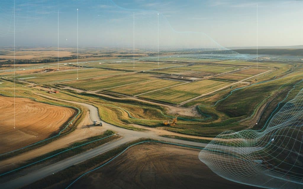
Photogrammetry is the process of using overlapping images to create accurate measurements and digital models of land. These images are captured from drones or aircraft and processed into detailed outputs such as maps, surface models and 3D visuals.
In land development, photogrammetry replaces slow manual surveying methods with a faster and more scalable solution. It provides reliable data across large areas without the need for constant ground access.
Why Photogrammetry Fits Large Scale Projects Perfectly
It covers massive areas efficiently
Traditional survey methods struggle with scale. Walking long sites takes time and resources.
Whereas, with drone photogrammetry, you can capture hundreds of acres in a single flight. This makes it ideal for subdivisions, industrial zones, highways and mixed use developments.
The speed of capture allows teams to gather data early and revisit sites frequently as work progresses.
It delivers consistent and accurate measurements
Photogrammetry survey outputs are built from hundreds or thousands of images stitched together through advanced processing. The result is a highly accurate representation of the site.
Developers use this data to measure distances, elevations, slopes and volumes. This consistency reduces disputes and supports better planning decisions.
It supports better collaboration
Large projects involve many stakeholders. Engineers, planners, contractors and investors all need clarity. Three dimensional models created through 3D mapping make it easier for everyone to understand the site.
Instead of interpreting flat drawings teams can explore the terrain visually. This improves communication and reduces misunderstandings.
How Drone Photogrammetry Improves Planning and Design
Better site analysis from the start
Drone photogrammetry gives you a complete view of the land before construction begins. You can assess terrain conditions, drainage patterns, access points and environmental constraints.
These insights help you avoid design mistakes early on. Additionally, it also allows planners to adapt layouts to real world conditions rather than assumptions.
Accurate cut and fill calculations
Earthworks are a major cost in land development. Photogrammetry helps calculate volumes precisely. You can estimate how much material needs to be moved and where.
This level of accuracy improves budgeting and scheduling. It also reduces waste and rework.
Ongoing monitoring during development
As construction progresses photogrammetry survey data can be collected repeatedly. This allows teams to track changes over time.
You can compare current conditions with earlier models to monitor progress. This helps ensure work stays aligned with plans and timelines.
The Role of Photogrammetry in Construction Site Mapping
Construction site mapping benefits greatly from photogrammetry. Instead of relying on outdated drawings teams can access up to date visuals of the site.
These maps support logistics planning, safety assessments and quality control. They help identify conflicts between trades and ensure that structures are built in the right locations.
Photogrammetry also improves documentation. Each survey creates a visual record of progress that can be reviewed later if questions arise.
How Aerial Mapping Services Add Value
Aerial mapping services powered by photogrammetry give developers a strategic advantage. They provide accurate data without interrupting operations.
Because drones capture data from above there is minimal disruption to work on the ground. This makes it easier to integrate surveys into active construction schedules.
Professional aerial mapping services also ensure that data is processed correctly. High quality outputs depend on proper flight planning, image overlap and processing expertise.
Why Photogrammetry Reduces Risk in Land Development
Risk in land development often comes from uncertainty. Unknown terrain conditions, unclear boundaries or inaccurate measurements can derail projects.
Photogrammetry reduces this uncertainty. It gives you confidence in your data. It supports better decision making and reduces surprises.
By using photogrammetry developers can identify issues early. They can adjust plans before problems become expensive. This proactive approach saves time and money.
How Rekon Applies Photogrammetry to Real Projects
At Rekon Solutions, photogrammetry is used to support large scale land development across multiple sectors. Our team delivers drone photogrammetry surveys that provide accurate three dimensional models and detailed site maps.
We help clients visualize land conditions, plan construction phases and monitor progress over time. Our aerial mapping services integrate seamlessly with planning and engineering workflows.
By combining advanced capture methods with careful data processing Rekon ensures that every photogrammetry survey delivers reliable and actionable insights.
The Future of Land Development with Photogrammetry
As land development projects grow in scale and complexity the need for accurate data will only increase. Photogrammetry is becoming a standard tool rather than a specialized option.
Advances in drone technology and processing software continue to improve accuracy and efficiency. This makes photogrammetry more accessible and more powerful.
Developers who adopt photogrammetry early gain a competitive edge. They plan better respond faster and build with greater confidence.
Frequently Asked Questions
What is photogrammetry used for in land development
Photogrammetry is used to create accurate maps, models and measurements of land. It supports planning, design, earthworks and progress tracking in large development projects.
How accurate is drone photogrammetry
When performed correctly drone photogrammetry delivers high accuracy suitable for planning and monitoring. Accuracy depends on flight planning, ground control and processing quality.
How does photogrammetry compare to traditional surveying
Photogrammetry covers larger areas faster and provides visual context. Traditional surveying may still be used for specific control points but photogrammetry enhances overall efficiency.
Can photogrammetry be used throughout a project lifecycle
Yes, photogrammetry survey data can be collected before, during and after construction. This supports planning, monitoring and documentation at every stage.
Conclusion
Photogrammetry is transforming how large scale land development projects are planned and executed. It provides accurate data, clear visuals and efficient workflows.
With drone photogrammetry and 3D mapping developers gain better insight into their sites. With construction site mapping and aerial mapping services they stay informed as projects evolve.
If you are managing a large land development project and want data you can trust, photogrammetry is the tool that brings clarity, confidence and control. Rekon Solutions is ready to support your next project with reliable photogrammetry services built for scale.
