Surveying technology has changed dramatically over the last decade.
Projects now move faster, expectations for accuracy are higher, and teams need reliable data sooner than ever.
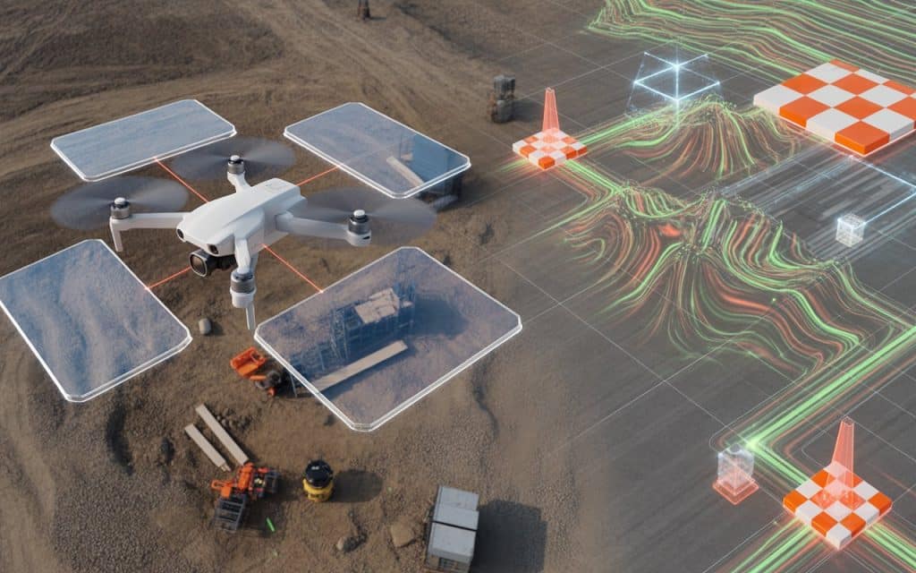
That is why many professionals are turning to a drone photogrammetry survey to capture detailed spatial information quickly.
Instead of relying entirely on manual measurements, aerial imagery now plays a major role in modern surveys.
Drones capture hundreds of overlapping photos that software converts into maps and 3D models. When the workflow is planned correctly, the results can be extremely accurate.
However, achieving consistent results requires more than simply flying a drone and taking photos.
Understanding the aerial mapping workflow, using ground control points GCPs, and applying correct survey data processing techniques make all the difference. Let’s explore how you can get your photogrammetry survey right.
Why photogrammetry is transforming modern surveying
Photogrammetry uses photographs to measure distances, shapes, and elevation. By analyzing overlapping images, software identifies matching features and reconstructs a three dimensional model of the terrain. This method is now widely used in construction, environmental monitoring, mining, and infrastructure planning.
One reason for this rapid adoption is efficiency. As per multiple studies, drone based photogrammetry can reduce field survey time significantly compared to traditional surveying methods.
Speed alone is not the only advantage. A well executed drone photogrammetry survey also produces highly detailed visual data that teams can use for measurements, progress monitoring, and planning.
Understanding the aerial mapping workflow
The foundation of successful photogrammetry begins with a structured aerial mapping workflow. Every stage, from planning the flight to processing the images, influences the quality of the final map.
The workflow typically begins with planning the survey area and determining flight paths. Drone flight planning software ensures that images overlap correctly and cover the entire site. After the flight, images move into survey data processing software where they are aligned, analyzed, and converted into maps.
This workflow might sound simple, but every step affects the final result. Poor flight planning, incorrect altitude, or insufficient image overlap can quickly reduce the accuracy of the entire survey.
Why ground control points GCPs matter
One of the most important elements of photogrammetry accuracy is the use of ground control points GCPs. These are marked reference points placed across the survey site whose exact coordinates are measured using high precision GPS equipment.
When images are processed, these control points help the software align the model with real world coordinates. Without GCPs, photogrammetry models may still look accurate visually but may contain positional errors.
Many surveyors consider GCPs essential when producing engineering grade mapping. By anchoring the model to known coordinates, the final dataset becomes far more reliable for planning and design work.
The role of RTK drone mapping
Another way to improve the reliability of a drone photogrammetry survey is through RTK drone mapping. RTK stands for Real Time Kinematic positioning, a technology that improves the GPS accuracy of the drone itself.
With RTK systems, the drone receives correction signals from a base station while flying. These corrections allow the drone to record extremely precise coordinates for each image it captures.
Research shows that RTK enabled drone surveys can achieve positional accuracy within 2 to 5 centimeters under proper conditions.
This level of accuracy significantly reduces the number of control points required and improves efficiency during field operations.
Photogrammetry accuracy tips that make a real difference
Even with the best technology available, accuracy still depends on how the survey is conducted. Small adjustments in flight planning and processing can dramatically improve results.
Here are several practical photogrammetry accuracy tips that experienced surveyors rely on.
- Plan sufficient image overlap during the flight mission.
- Use ground control points whenever engineering level accuracy is required.
- Maintain consistent altitude and camera angle across the survey.
- Ensure proper lighting conditions to avoid shadows and distortion.
- Use reliable software for survey data processing.
Following these simple practices ensures your drone photogrammetry survey produces dependable data.
Why survey data processing is critical?
Capturing aerial imagery is only the beginning of the process. The real transformation happens during survey data processing, where specialized software analyzes thousands of images and converts them into spatial data.
During processing, software identifies matching features across multiple images. These matches allow the system to calculate camera positions and reconstruct a detailed point cloud of the surveyed area. From this dataset, the software generates orthomosaic maps, digital surface models, and 3D terrain models.
The quality of this stage determines how useful the final output will be. Poor processing choices can introduce distortion or alignment errors. That is why experienced survey teams rely on professional processing workflows.
How is photogrammetry used in surveying?
Photogrammetry supports a wide range of surveying applications today. Construction companies use it to monitor site progress and calculate material volumes. Engineers rely on aerial maps for infrastructure planning and site design.
Environmental scientists also benefit from photogrammetry surveys. They use aerial data to track erosion, monitor vegetation, and study landscape changes over time.
If you want to understand how overlapping imagery creates maps in more detail, our previous article on Photogrammetry Mapping explains the process step by step.
How accurate is photogrammetry
When executed correctly, photogrammetry can achieve impressive accuracy. With proper image overlap, well placed GCPs, and accurate GPS data, survey grade results are achievable.
However, accuracy depends on several factors including camera quality, flight planning, and environmental conditions. Dense vegetation or poor lighting can reduce measurement precision.
For most construction and planning projects, photogrammetry accuracy is more than sufficient. In situations where dense vegetation obscures the ground surface, LiDAR may provide better elevation results.
Is LiDAR or photogrammetry more accurate
This question comes up frequently when comparing survey technologies. The answer depends on the type of terrain being mapped.
Photogrammetry performs extremely well on open terrain where surfaces are clearly visible. In these environments, aerial imagery produces detailed and visually rich maps.
Choosing the right technology for your survey
In many projects, the best approach is not choosing one technology over the other. Instead, survey teams combine multiple data collection methods depending on site conditions.
Photogrammetry remains one of the most efficient and cost effective options for aerial mapping. With the right workflow and equipment, a drone photogrammetry survey can produce highly reliable spatial data for planning and analysis.
Organizations looking for cost effective surveying methods often start with photogrammetry because of its speed and flexibility.
Rekon expertise in aerial surveying
At Rekon Solutions, drone based surveying focuses on accuracy, efficiency, and reliable data delivery. Our team combines advanced photogrammetry workflows with professional data processing techniques.
This approach ensures your survey results support real world planning, engineering, and infrastructure decisions.
Moving forward with confidence
Surveying accuracy depends on the right combination of planning, technology, and expertise. When the aerial mapping workflow is designed correctly and supported by tools like RTK drone mapping and ground control points GCPs, photogrammetry delivers powerful results.
A well executed drone photogrammetry survey can reduce project timelines, improve decision making, and provide reliable spatial data for complex projects.
If you are considering aerial surveying for your next project, contact our team to discuss how photogrammetry can support your mapping goals.