The world of land surveying is undergoing a significant transformation, with land surveying drones leading the charge.
These advanced technologies are making surveys faster, more efficient, and much more accurate.
In industries like construction, agriculture, and real estate, surveying with drones is quickly becoming a smarter alternative to traditional survey methods.
If you’re wondering how drones are changing the surveying industry and why they’re becoming a must-have tool for professionals, read on.
In this blog, we will explore what land surveying drones are, how they work, and why they’re the future of land surveys. We’ll also dive into their key benefits and the industries that are reaping the rewards.
What Are Land Surveying Drones?
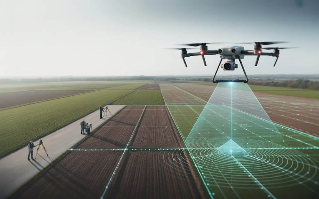
Land surveying drones are unmanned aerial vehicles (UAVs) equipped with cameras, sensors, and GPS technology designed to capture detailed land data from above. These drones fly over a survey area and use specialized equipment like high-resolution cameras or LiDAR sensors to collect visual and spatial data.
Drone land surveys are then processed using advanced software to generate maps, 3D models, and other geospatial data. With these drones, surveyors can capture high-quality imagery and precise measurements without having to walk the land themselves or set up expensive equipment like scaffolding or cranes.
Compared to traditional surveying methods, UAV land mapping using drones is much faster and more cost-effective. Drones can survey large areas in a fraction of the time and deliver highly accurate results with less manpower involved.
How Do Land Surveying Drones Work?
Land surveying drones are typically equipped with cameras and sensors, including LiDAR (Light Detection and Ranging), which uses laser pulses to measure distances to objects on the ground. This technology creates a 3D point cloud of the area, providing detailed measurements of terrain, vegetation, and man-made structures.
The drone is programmed to follow a pre-determined flight path to capture images or data points. The UAV is controlled by a trained operator, but the technology allows for autonomous flights, ensuring greater accuracy and precision in data collection.
Once the flight is completed, the captured data is processed using software. For example, photogrammetry software stitches together aerial images into a high-resolution map. And LiDAR data creates precise digital terrain models (DTMs) and digital surface models (DSMs).
The result is a detailed 2D or 3D map of the area being surveyed, which is then used by surveyors, engineers, and planners for further analysis and decision-making.
Why Are Land Surveying Drones Better Than Traditional Methods?
1. Faster Data Collection
One of the main advantages of surveying with drones is the speed at which data can be collected. In the past, traditional land surveys would require teams of surveyors to walk the land, take manual measurements, and record data. This process could take days or even weeks, depending on the size of the area being surveyed.
With land surveying drones, large areas can be surveyed in a matter of hours, significantly reducing the time required to gather the necessary data. Drones can cover areas that would take teams of workers much longer to survey, and they can do so in just one flight.
2. Improved Accuracy
Drone survey technology allows for UAV land mapping with incredible precision. Drones are equipped with GPS systems that ensure measurements are accurate to within a few centimeters. Advanced sensors, like LiDAR, capture data points with a level of detail that traditional surveying methods simply can’t match.
With GIS drone mapping, the accuracy of the data improves because drones can capture images and measurements from the air, eliminating the risk of human error that can occur in manual data collection. The use of GPS and LiDAR technology ensures that the data collected is highly precise and reliable.
3. Cost-Effective
In traditional land surveys, the cost can quickly add up. Surveyors need to use expensive equipment, hire additional labor, and sometimes even shut down work sites to perform their surveys. These costs can be prohibitive for smaller projects or businesses.
In contrast, land surveying drones are a more affordable option. While drones may require an initial investment, their ability to perform surveys more quickly and with fewer people involved makes them a cost-effective alternative. With drones, businesses can reduce labor costs, avoid the need for expensive equipment, and complete surveys in less time, ultimately saving money.
4. Safety Benefits
Land surveys often require workers to enter hazardous areas, such as tall buildings, steep slopes, or unstable terrain. This exposes surveyors to significant risks, such as falls or accidents with heavy equipment.
UAV land mapping eliminates much of this risk by allowing surveyors to collect data from the safety of the ground. Drones can easily fly over difficult or dangerous areas, gathering all the necessary data without putting workers in harm’s way. This makes drones an invaluable tool for industries like construction, mining, and infrastructure, where safety is a top priority.
5. Easier Monitoring and Repeat Surveys
Once land surveying drones have been used to map an area, it’s easy to repeat the survey at any time. With traditional methods, re-surveying a site might involve mobilizing a full team and equipment to go back to the location. With drones, surveys can be repeated quickly, giving businesses the ability to monitor progress and track changes over time.
For example, in large construction projects, drones can be flown regularly to monitor how the site is changing. These frequent updates help ensure that projects stay on schedule and within budget.
Industries That Benefit From Land Surveying Drones
1. Construction
In construction, drone land surveys are used to assess sites, plan projects, and track progress. With high-quality aerial data, construction teams can make more informed decisions about excavation, grading, and building placement.
Drones are particularly useful for tracking the progress of large-scale projects. Construction managers can use surveying with drones to compare the actual progress with the original plans and identify potential issues before they become costly problems.
2. Agriculture
UAV land mapping is also beneficial in agriculture. Farmers use drones to monitor crop health, assess irrigation needs, and track soil conditions. Drones equipped with specialized cameras and sensors can help farmers spot early signs of disease or pests, enabling them to take action before significant damage occurs.
Additionally, drones can be used to monitor large farming areas quickly and efficiently, saving time and labor costs while improving productivity.
3. Real Estate
In real estate, land surveying drones are used to capture stunning aerial views of properties, giving potential buyers a comprehensive look at the layout and surrounding area. Real estate agents use drones to create virtual tours and high-resolution maps, enhancing property listings and increasing buyer interest.
4. Environmental Monitoring
Environmental agencies use drones to monitor land changes, track vegetation, and assess the impacts of climate change. GIS drone mapping helps environmental scientists create accurate models of ecosystems, which are used for conservation efforts and land management.
5. Mining and Energy
In industries like mining and energy, surveying with drones helps companies track resources, assess terrain, and monitor infrastructure. Drones are used to inspect pipelines, power lines, and other critical infrastructure, reducing the need for workers to access dangerous or remote areas.
How Rekon Solutions Can Help
Rekon Solutions offers professional land surveying drones services tailored to your business needs. Whether you need a drone land survey, UAV land mapping, or topographic drone survey, our team is equipped with the latest technology to deliver high-accuracy data quickly and safely.
Our UAV experts work with you to ensure that your project is completed on time, within budget, and with the most reliable data possible. Reach out today to learn how our drone survey technology can improve your operations.
Check out our previous blog on how UAV surveying is changing the way industries work to learn more about the benefits of using drones in your projects.
Conclusion
Land surveying drones are revolutionizing the way land and infrastructure surveys are conducted.
With faster data collection, better accuracy, and increased safety, drones offer an efficient and cost-effective alternative to traditional methods. Whether you’re in construction, agriculture, real estate, or any other industry, drones can help you gather precise data in less time.
By adopting UAV land mapping and drone survey technology, you can ensure that your projects are completed on time and with accurate information.
If you’re ready to experience the benefits of land surveying drones, Rekon Solutions is here to help you get started.
