Have You Struggled with Mapping in Remote Locations?
Surveying in remote areas is no easy feat. Whether you’re mapping rugged terrains, dense forests, or mountainous regions, traditional surveying methods often fall short.
That’s where LiDAR in remote areas comes into play.
LiDAR technology has become a game-changer for precision mapping in locations that were once difficult to reach.
In this blog, we’ll explore why LiDAR for rugged terrain and remote surveying with LiDAR are transforming how we collect data in remote areas.
If you’re looking for a faster, more accurate way to map challenging environments, keep reading!
What Is LiDAR in Remote Areas?
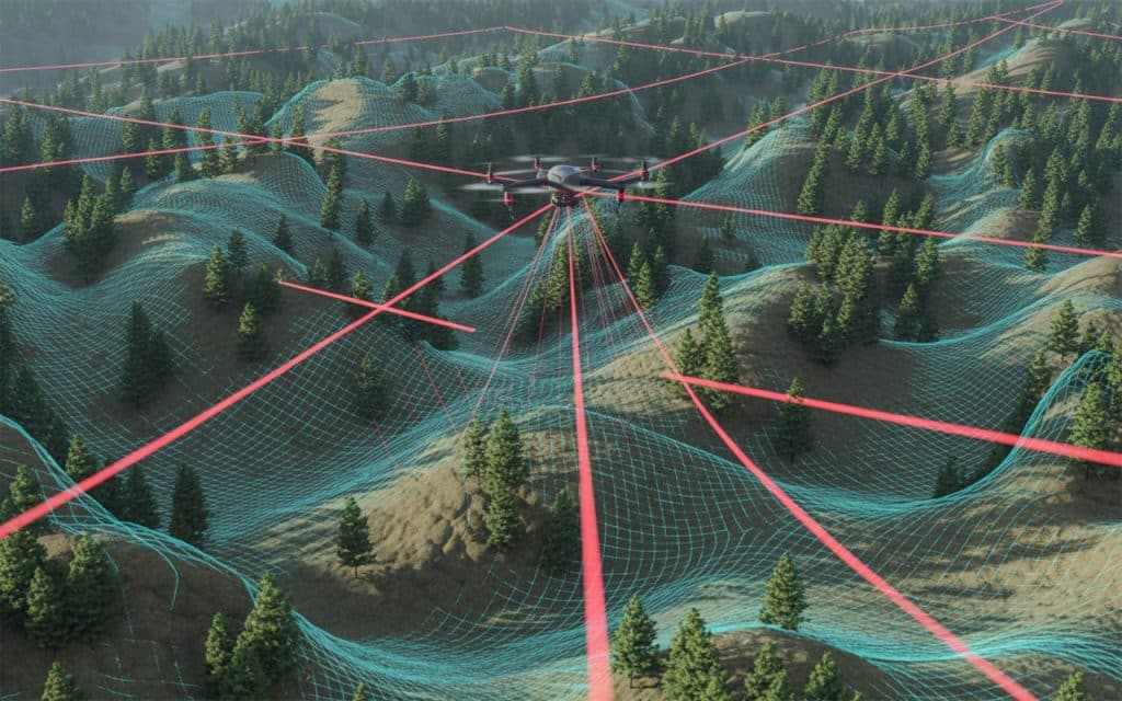
LiDAR (Light Detection and Ranging) uses laser pulses to measure distances between the sensor and the surface of the Earth. These pulses are reflected back to the sensor, providing highly accurate 3D data.
When applied to remote areas, LiDAR technology allows for precise mapping of terrain, vegetation, and even infrastructure without needing direct access.
In areas that are difficult to navigate, such as dense forests, mountains, or unstable environments, LiDAR enables surveyors to capture valuable data from above, using drones or aircraft.
Why LiDAR is Revolutionizing Mapping in Remote Areas
1. LiDAR Can Access Hard-to-Reach Locations
One of the biggest challenges in mapping remote areas is access. In many cases, it’s not feasible or safe to send survey teams into rugged or inaccessible locations. LiDAR for rugged terrain solves this by providing a bird’s-eye view of the landscape. Drones and aircraft equipped with LiDAR sensors can fly over difficult terrain and gather data in places that would otherwise be off-limits.
For example, if you’re working in a dense forest or a remote mountain range, LiDAR in remote areas allows you to map the terrain without having to physically traverse the land. This can significantly reduce the time, cost, and risk associated with traditional field surveys.
2. Faster Data Collection
Traditional surveying methods in remote areas can be slow and labor-intensive. LiDAR for rugged terrain, on the other hand, dramatically speeds up the process.
Drones can cover vast areas in a short amount of time, capturing detailed precision mapping data as they fly over the landscape. Unlike traditional methods that require extensive ground surveys, remote surveying with LiDAR captures data quickly and efficiently.
This is particularly valuable in industries like forestry, mining, and environmental monitoring, where timely data is crucial for decision-making and project management.
3. High-Resolution Data for Better Decision-Making
Accuracy is essential when surveying remote areas, and LiDAR in remote areas provides some of the most precise data available.
LiDAR sensors can capture millions of data points per second, creating detailed 3D models of the landscape. This level of precision is ideal for mapping complex features like topography, vegetation, and infrastructure.
For example, LiDAR for rugged terrain can create detailed surface models of forested areas, capturing the heights of trees, the slope of the ground, and the distance between features. This data can then be used for planning purposes, such as determining the best route for a new road or assessing the stability of a hillside for construction.
4. Minimizing Environmental Impact
Surveying in remote areas often requires heavy equipment or human presence, which can disturb the environment.
LiDAR in remote areas minimizes this impact. By using drones or aircraft, surveyors can collect data without disturbing the land or vegetation.
Unlike traditional methods, there’s no need for physical contact with the terrain, reducing the risk of environmental damage.
This is especially important in sensitive ecosystems, such as wetlands, wildlife habitats, or protected lands. Remote surveying with LiDAR allows for thorough mapping without compromising the environment.
5. Cost-Effective Long-Term Solution
While the initial cost of LiDAR for rugged terrain may be higher than traditional surveying methods, the long-term benefits far outweigh the expense.
LiDAR in remote areas reduces the need for expensive field teams, travel costs, and lengthy surveys.
In addition, the accuracy and speed of LiDAR reduce the need for follow-up surveys or data corrections, which can further lower costs.
When you consider the time saved, the reduction in environmental impact, and the higher-quality data, LiDAR becomes a highly cost-effective solution for precision mapping in remote areas.
Applications of LiDAR in Remote Areas
1. Forestry and Vegetation Mapping
In forestry, LiDAR for rugged terrain can be used to map tree canopy heights, estimate biomass, and assess forest density. This is crucial for forest management, environmental studies, and resource planning.
LiDAR technology also helps in calculating the volume of timber available for harvest, which can improve the efficiency of the logging industry.
2. Mining and Exploration
LiDAR in remote areas is widely used in mining and exploration. The technology enables surveyors to create accurate models of mining sites, assess terrain stability, and monitor changes over time.
LiDAR data is particularly useful in remote surveying with LiDAR for mapping areas that are difficult to access, such as remote mining sites or riverbeds.
3. Environmental Monitoring and Conservation
LiDAR technology is being increasingly used in environmental monitoring to track changes in the landscape over time.
For example, LiDAR in remote areas can be used to monitor glacier movements, coastal erosion, and deforestation. The ability to gather detailed, precise data from the air makes LiDAR an invaluable tool for environmental scientists working in remote or protected areas.
4. Infrastructure Development
Whether it’s road construction, pipeline installation, or powerline mapping, precision mapping with LiDAR is vital for planning infrastructure projects in remote areas.
LiDAR for rugged terrain helps planners understand the landscape and make informed decisions about routes, designs, and construction methods. It also enables surveyors to identify potential risks such as unstable ground or flood zones.
Conclusion: Embrace the Future of Remote Mapping with LiDAR
If you’re working on an infrastructure project in a remote area, LiDAR in remote areas offers the precision, speed, and cost-efficiency you need to succeed.
From surveying rugged terrain to minimizing environmental impact, LiDAR is revolutionizing how we collect and analyze data in the world’s most challenging environments.
At Rekon, we specialize in providing remote surveying with LiDAR to help you map even the most difficult terrains with ease.
Whether you’re in forestry, mining, environmental monitoring, or infrastructure development, our LiDAR for rugged terrain solutions provide accurate and reliable data that drives better decisions.
Frequently Asked Questions
What is the main advantage of using LiDAR in surveying?
LiDAR provides high-precision, detailed data quickly, even in difficult-to-access areas. It reduces the time and cost associated with traditional methods while improving accuracy.
What is the accuracy of LiDAR surveys?
LiDAR can achieve accuracy levels of 1-3 centimeters, depending on the equipment used and the conditions of the terrain.
How is LiDAR used in mining?
LiDAR is used in mining to create 3D models of mining sites, monitor stockpile volumes, and assess the stability of mine sites.
What factors can influence the accuracy of LiDAR measurements?
The accuracy of LiDAR measurements can be affected by factors such as the quality of the equipment, weather conditions, the angle of scanning, and the complexity of the terrain.
