Have you ever wondered how drone mapping is revolutionizing the way we capture and analyze landscapes?
Whether you’re managing a construction project, surveying land, or monitoring environmental changes, mapping has been made easy with photogrammetry.
It is reshaping how data is collected and visualized.
With drone mapping, what once took weeks of fieldwork can now be completed in hours — with higher accuracy and lower costs.
What is Drone Mapping?
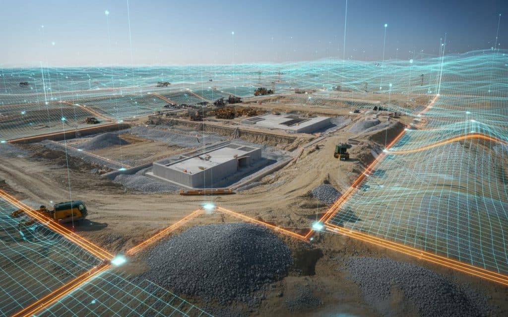
Drone mapping is the process of using unmanned aerial vehicles equipped with high-resolution cameras and drone photogrammetry software to capture detailed images of the ground. These images are then stitched together to create highly accurate 2D maps, 3D models, and digital elevation models (DEMs).
The technique behind mapping made easy with photogrammetry is simple but powerful.
Drones capture hundreds or even thousands of overlapping photos from multiple angles. Photogrammetry software then processes these images, calculating depth and distance to reconstruct the terrain in remarkable detail.
According to a recent study published in the MDPI Journal of Drones, aerial photogrammetry delivers “high-accuracy spatial data and cost-effective mapping for large-scale applications” — making it ideal for industries like mining, construction, and infrastructure planning (source).
Why Do Most Businesses Rely on Drone Mapping?
1. Speed and Efficiency
Traditional land surveys can take days or weeks, depending on terrain and accessibility.
Drone mapping drastically reduces that time. For example, a drone can map 100 acres in under an hour — while providing centimeter-level precision.
This speed allows companies to collect data more frequently, improving project tracking and decision-making.
2. Cost Savings
Drone mapping removes the need for expensive equipment, large teams, and risky manual surveys. The cost per survey is often reduced by up to 70%, according to industry research. Companies can reinvest those savings into better equipment, analysis, or faster project turnaround.
3. High Accuracy
With the right setup, including ground control points (GCPs) and real-time kinematics (RTK) positioning, drone photogrammetry achieves sub-centimeter accuracy. This precision makes it reliable for volume measurement, contour mapping, and construction quality assurance.
4. Safety and Accessibility
Drones can fly into hazardous areas — from steep quarries to flooded zones — where human access is unsafe. This ability not only reduces risk but also ensures continuous monitoring of areas affected by erosion, landslides, or structural instability.
5. Scalability
From a small residential site to a massive infrastructure project, drone mapping can scale effortlessly. Advanced drones can fly longer distances and capture large tracts of land without compromising data quality.
How Does Drone Photogrammetry Work?
1. Flight Planning
Surveyors define the area of interest, flight altitude, image overlap, and camera settings. The goal is to capture overlapping images (usually 70–80%) for accurate 3D reconstruction.
2. Image Capture
During flight, the drone captures high-resolution images along a pre-programmed path. The onboard GPS tags each image with coordinates, ensuring spatial accuracy.
3. Data Processing
Once the flight is complete, the data is imported into drone photogrammetry software. This software aligns overlapping images and calculates 3D coordinates for millions of points, forming a dense point cloud.
4. 3D Model and Map Creation
From the point cloud, the system generates a 3D model, orthomosaic, or contour map. These outputs are used in CAD, GIS, or BIM applications for planning and analysis.
5. Analysis and Deliverables
The deliverables from drone mapping include orthophotos, DEMs, 3D meshes, volume measurements, and site progress reports. These datasets are invaluable for engineers, project managers, and environmental scientists.
Real-World Applications of Drone Mapping
Construction and Infrastructure
In construction, drone mapping helps project managers monitor progress, measure stockpiles, and identify issues early. Weekly drone surveys can detect deviations between actual and planned designs, reducing costly rework.
Mining and Quarrying
Mining operations use drone photogrammetry to measure excavation volumes, assess safety, and monitor pit wall stability. Accurate volume data ensures better inventory management and production forecasting.
Agriculture and Land Management
Farmers and land managers use drone mapping to analyze crop health, soil conditions, and irrigation efficiency. The detailed 3D models created through drone photogrammetry help optimize planting and resource use.
Environmental Monitoring
For environmental scientists, drone mapping provides precise data on erosion, vegetation change, and floodplain dynamics. It enables early intervention in areas affected by natural disasters or human activities.
Urban Planning and Smart Cities
Urban planners rely on drone mapping to visualize terrain, buildings, and infrastructure. The models generated are crucial for zoning, road alignment, and sustainable city design.
Choosing the Right Drone Mapping Solution
When investing in drone mapping or drone photogrammetry, consider:
- Camera Quality: A higher-resolution camera ensures more detail in models and maps.
- Flight Time: Longer battery life means more area covered per mission.
- Software Compatibility: Look for photogrammetry tools that integrate with your existing GIS or CAD workflows.
- Accuracy Tools: Drones with RTK or PPK systems improve positional accuracy.
- Service Model: Businesses can either buy their own drone mapping equipment or outsource to providers like Rekon Solutions for expert data collection and analysis.
Rekon Solutions offers advanced drone mapping and drone photogrammetry services that deliver precise, real-time insights for construction, mining, environmental, and infrastructure projects. Our drones are equipped with state-of-the-art cameras and sensors to ensure the highest quality results.
Common Challenges
Even though drone mapping simplifies data collection, it comes with considerations:
- Weather Conditions: Rain, fog, and wind can affect image quality and flight stability.
- Regulations: Always ensure drone operations comply with local aviation laws.
- Data Storage: High-resolution image sets can require significant storage and processing power.
- Accuracy Control: Ground control points (GCPs) are essential for ensuring survey precision.
The Future of Drone Mapping
The future of drone mapping lies in automation and AI. Real-time mapping, cloud-based processing, and AI-powered anomaly detection will make photogrammetry faster and more intelligent. Industries are increasingly integrating drones into digital twin models, allowing real-time decision-making across infrastructure and construction projects.
According to MarketsandMarkets, the global drone mapping and survey industry is expected to exceed $35 billion by 2030, driven by adoption in construction, agriculture, and logistics.
Conclusion
Mapping made easy with photogrammetry has reshaped the way we view the world. With drone mapping, collecting, analyzing, and sharing geospatial data has never been faster or more accurate.
From large-scale mining operations to precise infrastructure design, the combination of drone photogrammetry and advanced analytics empowers decision-makers with clarity and confidence.
To learn how Rekon Solutions can simplify your next mapping project with high-accuracy drone mapping services, get in touch with our team today.
FAQs
What is drone mapping used for?
It is used for creating detailed 2D and 3D maps for construction, mining, agriculture, and environmental projects.
How accurate is drone mapping?
With RTK or PPK systems and ground control points, drone mapping can achieve sub-centimeter accuracy.
Is drone photogrammetry better than LiDAR?
Drone photogrammetry is ideal for visual and terrain mapping. LiDAR performs better in dense vegetation or low-light conditions.
Can drone mapping be outsourced?
Yes. Companies like Rekon Solutions offer turnkey drone mapping services, from flight planning to data delivery.
