Have you ever wondered how drones are revolutionizing land surveying?
In the past, land surveying required labor-intensive methods and was time-consuming.
Now, UAV drone survey technology has completely changed that.
Drones make surveying faster, more accurate, and cost-effective.
In this blog, we’ll explore how UAV surveying works and its real-world applications. We’ll also look at how it’s transforming the industry by offering improved accuracy and efficiency.
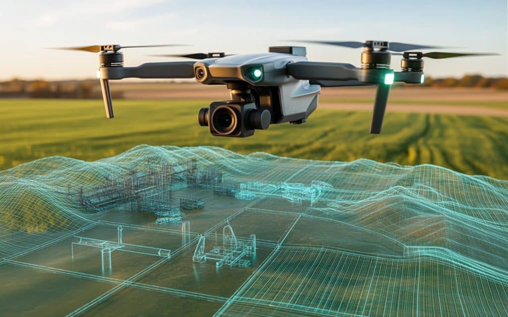
What Is a UAV Drone Survey?
A UAV drone survey uses drones equipped with cameras and sensors.These drones capture data from the air to create maps, 3D models, and digital elevation models.
UAV surveying allows large areas to be surveyed quickly and accurately. This is a huge improvement over traditional land surveying, which can take days or weeks.
Drone mapping services use drones to collect precise measurements and imagery. This data is processed into maps, models, and reports, making it more efficient and effective.
The Accuracy of UAV Drone Surveys
UAV drone survey technology provides high-precision data. Drones equipped with LiDAR or photogrammetry sensors capture millions of data points every second. This creates accurate 3D models of terrain, structures, and infrastructure.
The precision of these surveys is crucial for projects that require reliable measurements. With high-accuracy UAV mapping, you can create detailed maps that were once difficult to produce.
Cost Savings with UAV Surveying
One of the biggest advantages of UAV surveying is the cost savings. Traditional surveying methods require expensive equipment and manual labor.
On the other hand, UAV drone surveys reduce labor costs by using drones that cover large areas quickly. Drones can be deployed with minimal setup, saving time and money.
By reducing both labor and equipment costs, drone mapping services make surveying more affordable. This makes it possible to survey larger areas for a fraction of the cost of traditional methods.
Real-World Use Cases for UAV Drone Surveying
Construction and Infrastructure Projects
UAV drone surveys are commonly used in construction to map land and inspect structures.
Aerial survey drones provide high-resolution data to help engineers and architects. They make it easier to monitor construction sites and ensure everything is on track.
Drones are used to create topographic maps and 3D models for design and planning. This data helps construction teams make informed decisions and prevent costly mistakes.
Agriculture and Environmental Monitoring
In agriculture, UAV surveying helps monitor crop health, assess irrigation needs, and track land conditions.
Drones equipped with multispectral sensors can capture data about vegetation health. This allows farmers to optimize their practices and increase crop yield.
For environmental monitoring, drone mapping services are used to study ecosystems and habitats. Drones can capture data on land use, vegetation cover, and natural resources without disturbing the environment.
Mining and Resource Management
UAV drone surveys are used in mining to monitor mining sites, track excavation progress, and inspect stockpiles. Drones can create detailed 3D models of the land, allowing mining companies to assess the site.
Industrial drone inspection services help mining teams monitor the site without sending workers into dangerous areas. Drones also help with regulatory compliance by providing accurate and up-to-date data.
Real Estate and Land Development
In real estate, UAV drone surveys are used to capture aerial images of properties and land for sale.
Aerial real estate photography provides a clear view of the property’s size, layout, and surroundings. Real estate developers use UAV surveying to inspect potential development sites and plan accordingly.
Drones are also used to monitor construction progress and assess land conditions for development.
The Benefits of UAV Drone Surveying
1. Accuracy and Precision
UAV drone survey technology provides precise and accurate data for mapping and surveying projects. Drones equipped with LiDAR or high-resolution cameras capture detailed measurements.
This ensures the creation of highly accurate maps, models, and digital elevation models. High-accuracy UAV mapping is crucial for any project that demands reliability and precision.
2. Time and Cost Efficiency
Drone mapping services save time by covering large areas quickly. A drone can survey a site in hours, while traditional methods would take days or even weeks. This makes UAV surveying much more time-efficient and cost-effective.
By reducing the need for manual labor and expensive equipment, drones cut overall costs.
3. Safety
Safety is a top priority in any surveying project. UAV drone surveys eliminate the need for workers to access dangerous or hard-to-reach areas.
Drones can fly over tall buildings, hazardous terrain, or unstable structures to collect data. This reduces the risk of injury and allows workers to remain safe while still gathering critical information.
4. Accessibility
UAV surveying makes it easier to inspect areas that are difficult or dangerous to reach. Drones can access remote or rugged terrain that would be difficult or costly to survey by foot. This is particularly useful for surveying mountains, forests, coastlines, or large industrial sites.
With BC land surveying drones, it’s possible to collect data from challenging environments that are otherwise inaccessible.
How Rekon Solutions Uses UAV Drone Surveying
At Rekon Solutions, we specialize in UAV drone surveys for a variety of industries. Our team uses drone mapping services to help clients in construction, real estate, agriculture, mining, and more. We provide high-precision data that helps our clients make better decisions and plan projects effectively.
Whether you need topographic maps, 3D models, or aerial images, our UAV surveying technology can meet your needs. We focus on safety, accuracy, and efficiency, ensuring that our drone inspections provide the most reliable results.
The Future of UAV Drone Surveying
The future of UAV drone survey technology looks promising.
Advancements in drone technology will continue to improve the accuracy, efficiency, and safety of surveys.
As drones become more advanced, they will be able to capture even more precise data and cover larger areas.
UAV surveying will continue to revolutionize industries, providing quicker and more cost-effective solutions.
Conclusion
UAV drone surveys are transforming the way we approach land surveying, construction, and resource management.
By offering high accuracy, reducing costs, improving safety, and increasing efficiency, drones are quickly becoming the go-to tool for surveying projects.
Whether you’re in construction, real estate, mining, or agriculture, UAV surveying offers unmatched benefits.
At Rekon Solutions, we use drone mapping services to provide reliable, precise, and cost-effective solutions for your surveying needs.
Contact us today to learn more about how UAV drone surveys can enhance your next project.
