Have you ever wondered how professionals gather detailed and accurate maps so quickly?
The answer lies in UAV surveying.
UAV surveying uses unmanned aerial vehicles, or drones, to collect data from the air.
These drones can create high quality maps faster and with more detail than traditional methods.
In this blog, we will explore how UAV surveying works and why drone survey accuracy is so highly valued. You will also understand how these systems are changing land surveys and mapping workflows.
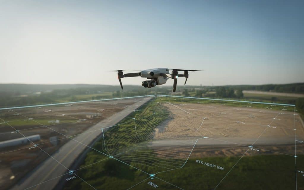
What Exactly Is UAV Surveying?
UAV surveying involves using drones to collect data about the land. Drones fly over an area and take pictures or laser measurements, and then this data is processed into maps and 3D models.
Some drones use cameras that take pictures from every angle. The software processes these images to create a detailed map. Other drones use lasers, which is called LiDAR, to measure distances accurately. These are both useful tools in UAV mapping services.
Once processed, these maps can show the shape, slope, and features of a piece of land, allowing professionals to plan projects and make decisions more effectively.
How UAV Surveying Works?
A drone is programmed to fly over a survey area. The flight paths are planned so the drone captures images that overlap, ensuring no area is missed.
After the drone collects all the data, the images and measurements are processed by special software. This software compares data points and creates a detailed map.
In some cases, the result is a simple 2D map, while in others it’s a 3D model of the land, showing hills, valleys, roads, and buildings in great detail. The data is often so accurate compared to traditional surveys that it can be used in situations where high precision is critical.
Why Is Drone Survey Accuracy Important?
When it comes to drone survey accuracy, you might wonder whether drones can match traditional land surveys in terms of precision. The answer is yes. Drone survey accuracy can be just as high, if not better, than conventional methods.
Accuracy depends on the sensor quality and the data processing. Some drones are equipped with RTK (Real-Time Kinematic) or PPK (Post-Processed Kinematic) GPS systems. These systems correct GPS signals, improving the location accuracy to within centimeters.
According to a report by ScienceDirect, LiDAR surveys from drones offer comparable or even higher accuracy than traditional GNSS RTK land surveys when both use proper control points. This makes UAV surveying a reliable solution for many industries that require high-precision data.
3 Common Types of UAV Surveys
UAV Land Survey
A UAV land survey is typically the first step in planning construction or development projects. Drones fly over property and collect data on boundaries, features, elevation, and ground texture.
Surveyors can then use this data to create maps for architects or engineers. Because drones collect data faster than teams on foot, project timelines are shortened, and operations get started sooner. There’s also less need for workers to climb over rough terrain or difficult landscapes.
Topographic Drone Survey
A topographic drone survey shows the height and shape of the land. This is especially useful for projects like land grading, road design, and earthworks. Drones can quickly produce digital terrain models and digital surface models. They show both ground and surface features, including buildings and trees.
Traditional surveys could take days to complete. With drones, this process can now be done in just a few hours, saving a lot of time.
Aerial Land Survey
An aerial land survey captures data from above, helping surveyors see large areas at once. It’s great for getting a big picture of a site before taking precise measurements.
For example, a large industrial site or a property development project can be assessed with a quick aerial land survey. This provides valuable insight into the layout, boundaries, and features of the area, giving teams the information they need to plan effectively.
5 Key Benefits of UAV Surveying
Faster Data Collection
One of the biggest advantages of UAV surveying is the speed at which data can be collected.
Instead of survey crews spending days or weeks walking the land, drones can cover a large area in just a few hours. This speeds up the entire surveying process and helps projects get started sooner.
Cost Savings
Using drones for UAV surveying is also more affordable than traditional methods. With fewer workers needed on the ground, and no expensive machinery like cranes or scaffolding, the costs of a survey are greatly reduced. The efficiency of drones also means less downtime, making the entire process cost-effective.
Better Safety
Many traditional surveying tasks require workers to enter dangerous or hard-to-reach areas. For example, workers may need to climb tall towers or enter areas that are unstable or far from safe paths.
UAV surveying removes this need. Drones can fly over high or hazardous areas and collect data safely, keeping workers on the ground where they’re safe.
High Quality Data
Drones can collect very high-resolution images and data, which can be turned into detailed maps. This is essential for engineers, planners, and architects who rely on the best possible data for their work.
Drones also help reduce the chances of human error, which is common in traditional surveying methods. As a result, the data collected is more accurate and reliable.
Easy to Repeat Surveys
Once drones have been deployed for the initial survey, repeating the same survey is simple. This allows for constant monitoring over time and gives an updated view of changes as they happen.
For example, if construction is progressing on a site, you can regularly fly a drone to monitor how the project is advancing and spot any problems that might be affecting the timeline. This ongoing monitoring helps avoid delays and ensures that everything runs smoothly.
How UAV Surveying Compares to Traditional Methods
Traditional surveying typically uses total stations, GNSS equipment, and manual labor to measure land. While these methods are precise, they can be slow and costly. Surveying large areas requires more time and resources, and errors can occur when manually collecting data.
On the other hand, UAV surveying uses aerial images and laser scans to create accurate maps more quickly. This allows for faster results, and with drones collecting data in real-time, it’s easier to keep projects on schedule and make adjustments as needed.
Drones don’t replace traditional surveying methods but are a complementary tool that enhances how surveys are done.
Applications Where UAV Surveying Excels
UAV surveys are used in various industries to improve how land is measured and analyzed:
- Construction and Development: Drones help with site planning, earthworks, and tracking project progress.
- Agriculture: Drones monitor crop health and assist with irrigation planning and pest control.
- Environmental Monitoring: Drones track changes in ecosystems, monitor erosion, and assess the impact of flooding or other natural events.
- Real Estate: Aerial views enhance property listings and show boundaries and features from above.
- Energy and Infrastructure: Drones inspect powerlines, pipelines, and wind turbines, reducing the need for workers to climb dangerous structures.
These are just a few examples of how UAV surveying can be used to enhance operations and decision-making.
Rekon Solutions and UAV Surveying
If you’re interested in leveraging the power of drones for surveying, Rekon Solutions can help. We specialize in UAV surveying services, offering topographic drone surveys, aerial land surveys, and more. Our expert team ensures you get accurate, reliable data quickly, making your projects more efficient and cost-effective.
For more information on how drones can help your business, check out our previous blog on LiDAR surveying services.
Conclusion
UAV surveying is changing the game for land and infrastructure mapping. It’s faster, more cost-effective, and often more accurate than traditional methods. From UAV land survey to topographic drone surveys, drones are allowing companies to get the data they need without slowing down operations.
As industries continue to rely on more advanced technology, drone surveying services will keep growing in importance.
If you’re ready to take advantage of faster, safer, and more reliable surveying, Rekon Solutions is here to help. Get in touch today to learn more about how our UAV surveying services can support your business.
