Waterways shape landscapes, support ecosystems, and influence infrastructure decisions.
Yet the most important information about rivers, lakes, and coastal environments lies beneath the surface.
That’s where a hydrographic bathymetric survey becomes essential.
By using advanced sonar and geospatial technologies, bathymetry reveals the hidden contours of underwater terrain. It helps engineers, environmental scientists, and planners understand aquatic environments with precision.
From inland water mapping to flood modeling and habitat monitoring, bathymetry provides the underwater data needed to make informed decisions.
What Is a Hydrographic Bathymetric Survey?
A hydrographic bathymetric survey measures the depth and shape of underwater terrain in rivers, lakes, reservoirs, and coastal areas. In simple terms, it is the underwater equivalent of a topographic survey on land.
Specialized sensors capture underwater depth measurements and combine them with precise positioning systems such as GNSS. The result is a detailed model of the aquatic landscape, including riverbeds, lake floors, and submerged structures.
These surveys support a wide range of applications, including:
- Floodplain analysis
- Infrastructure planning near water bodies
- Environmental and habitat monitoring
- Navigation safety assessments
By transforming sonar readings into accurate digital models, bathymetry makes it possible to visualize underwater terrain with remarkable clarity.
Why Is Inland Water Mapping Essential for Engineering Projects?
Many engineering and environmental projects rely on accurate data about water bodies. However, traditional mapping methods often focus only on visible terrain, leaving critical underwater features undocumented.
Inland water mapping fills this gap by providing detailed insights into underwater conditions.
This information is essential for:
1. Flood Risk Management
Riverbed shape directly influences water flow and flood behavior. Bathymetric surveys allow engineers to analyze channel depth, sediment buildup, and erosion patterns to better predict flood risks.
2. Infrastructure Design
Bridges, dams, culverts, and pipelines all interact with waterways. Without accurate bathymetric data, designing these structures can become risky and inefficient.
3. Environmental Protection
Aquatic habitats depend heavily on underwater terrain. Bathymetric data helps scientists understand habitat conditions and identify areas suitable for conservation or restoration.
How Riverbed Mapping Technology Works
Modern riverbed mapping technology combines multiple tools to collect and process underwater data efficiently.
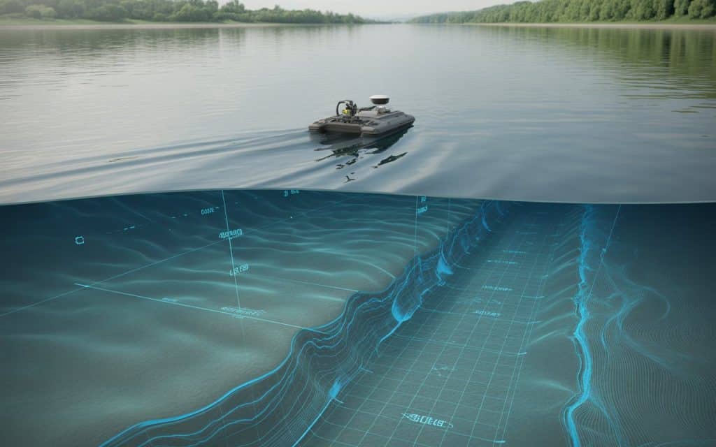
1. LiDAR or Unmanned Survey Vehicles (USVs)
Autonomous or remotely operated survey boats are commonly used to navigate rivers and lakes during bathymetric surveys. These compact vessels allow operators to safely collect data without entering hazardous waters.
LiDARs are particularly useful in areas with:
- Strong currents
- Shallow channels
- Limited access points
- Environmental sensitivity
2. Echo Sounders for Depth Measurement
Echo sounders are the core technology used in bathymetry. These instruments send acoustic pulses toward the waterbed and measure the time it takes for the signal to return.
From this information, survey systems calculate precise underwater depth measurements.
Modern echo sounders can collect data points multiple times per second, producing dense datasets that reveal underwater contours in great detail.
3. GNSS Positioning Systems
Accurate positioning is critical for bathymetric data. Multi-band GNSS receivers record the exact geographic coordinates of each depth measurement, ensuring the resulting dataset aligns perfectly with land-based survey data.
This combination of sonar depth readings and satellite positioning enables precise bathymetric data collection across large water bodies.
From Raw Data to Aquatic Terrain Models
Once field data is collected, it is processed to create detailed underwater maps and models.
Survey software combines the depth measurements and positioning data to generate:
- Digital Elevation Models (DEMs) of riverbeds or lake floors
- Contour maps showing underwater depth variations
- 3D terrain models for visualization and analysis
These outputs support aquatic terrain modeling, which helps engineers and scientists better understand underwater environments.
When bathymetric data is integrated with LiDAR or photogrammetry surveys, the result is a seamless land-to-water terrain model. This combined dataset provides a complete picture of the landscape above and below the waterline.
Contact us to learn more about Rekon’s bathymetric survey services.
Applications of Bathymetric Surveys
Bathymetry plays a crucial role in many industries where water and terrain interact.
1. Floodplain and Hydrological Studies
Hydrological models depend on accurate terrain information. Bathymetric surveys reveal the depth and slope of river channels, allowing engineers to simulate water flow and design flood mitigation strategies.
2. Environmental and Habitat Monitoring
Fish populations and aquatic ecosystems rely on specific underwater conditions. Bathymetry helps identify spawning grounds, sediment movement, and habitat structures that influence biodiversity.
Learn more: Save the Salmon! Bathymetry in a Hydrological Study
3. Infrastructure and Development Planning
Construction projects near rivers and lakes must account for underwater terrain. Bathymetric surveys help ensure bridges, docks, and shoreline developments are designed with accurate environmental data.
4. Sediment and Erosion Monitoring
Over time, sediment accumulation can alter water depth and channel structure. Bathymetric surveys allow researchers to track changes and identify areas where erosion or deposition may impact infrastructure or habitats.(1)
Advantages of Modern Bathymetric Data Collection
Compared to traditional manual depth measurements, modern bathymetric technology offers significant advantages.
1. Faster Data Collection
Autonomous survey vehicles and advanced sensors allow large water bodies to be mapped efficiently.
2. Improved Accuracy
High-frequency echo sounders and GNSS positioning provide reliable depth measurements for engineering and environmental analysis.
3. Safer Survey Operations
Remote survey systems eliminate the need for personnel to enter dangerous or fast-moving waters.
4. Integration with Other Geospatial Data
Bathymetric surveys can be combined with aerial LiDAR or drone photogrammetry to create comprehensive terrain models.
These benefits make bathymetry an essential component of modern mapping workflows.
The Future of Aquatic Terrain Mapping
As geospatial technology continues to evolve, bathymetry is becoming more integrated with other mapping techniques.
Advanced workflows now combine:
- Drone LiDAR for above-water terrain
- Photogrammetry for high-resolution imagery
- Bathymetry for underwater mapping
Together, these technologies provide a complete and highly detailed representation of complex environments.
For engineers, environmental scientists, and planners, this integrated approach offers a deeper understanding of landscapes where land and water meet.
Seeing What Lies Beneath
Water may hide the terrain beneath it, but modern survey technologies such as LiDAR make it possible to uncover those hidden details.
A hydrographic bathymetric survey reveals the underwater features that influence flood behavior, infrastructure design, and environmental health.
Through advanced riverbed mapping technology, precise underwater depth measurement, and accurate bathymetric data collection, organizations can make smarter decisions about water-related projects.
If your project demands terrain mapping beneath water, contact us to get a quote for bathymetric surveys using our latest LiDAR technology.
