Have you ever wondered if there’s a faster, more efficient way to get your survey done with more precision?
That’s where photogrammetry survey services come in, offering image-based land surveys that provide accurate, detailed data.
Instead of relying on manual measurements and traditional methods, aerial survey solutions and drone survey photogrammetry are changing the game.
In this blog, we’ll explain when you should consider using photogrammetry for your next survey and how this method offers a cost-effective surveying method for different projects.
What is Photogrammetry and Why Does It Matter for Surveys?
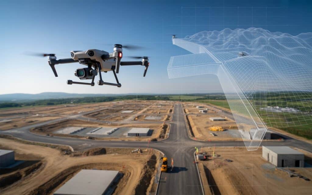
Photogrammetry is the science of making measurements from photographs. Using aerial imagery captured by drones or aircraft, photogrammetry provides data that can be used to create:
- 3D models
- Topographic maps
- Digital elevation models (DEMs).
This technique relies on overlapping aerial images, which are processed through advanced software to extract detailed, accurate measurements.
Lately, photogrammetry has become essential in fields like construction, environmental studies, mining, and urban planning.
Unlike traditional survey methods, photogrammetry survey services can be performed remotely, saving time and resources.
In fact, an AJOL research paper Assessment of Unmanned Aerial Vehicle Versus Terrestrial Method of Topographic Surveying show that drone-based photogrammetry applications can reduce survey times by up to 45% compared to traditional ground-based surveys, while increasing the accuracy of the data collected.
When Should You Use Photogrammetry for Your Survey?
1. When You Need Accurate 3D Mapping and Modeling
Photogrammetry is ideal when your project requires detailed 3D mapping of the terrain or environment. The technology captures accurate elevation data and models that can be used for planning and analysis.
Whether you’re developing a site, managing resources, or conducting environmental studies, drone survey photogrammetry provides the precision and detail needed to make informed decisions.
The ability to generate 3D models and orthophotos (georeferenced images) from aerial imagery allows you to visualize land features with clarity.
This capability is crucial when working on projects like:
- Urban development
- Construction site mapping
- Environmental monitoring
- Agricultural land assessments
Check out our previous blog on the role of LiDAR in mapping vast landscapes.
2. For Large-Scale or Difficult-to-Access Areas
One of the standout features of aerial survey solutions is their ability to survey large areas quickly and efficiently.
Whether it’s vast agricultural fields, expansive construction sites, or rugged terrains, photogrammetry survey services can cover a much larger area than traditional methods. This is especially valuable when the site is remote or challenging to access, such as in mountains, forests, or flood-prone regions.
In these cases, using drones equipped with high-quality cameras can provide clear, accurate data without the need for personnel to physically access hazardous or difficult locations.
With image-based land surveys, you can collect detailed measurements in a fraction of the time it would take with manual techniques.
3. When You Need Cost-Effective Surveying Methods
Photogrammetry is one of the most cost-effective surveying methods available today.
Traditionally, land surveys required heavy equipment, multiple crew members, and a significant amount of time to complete.
With drones and photogrammetry, these costs are significantly reduced. Aerial survey solutions eliminate the need for scaffolding, cranes, and manual labor, while providing high-quality data for your survey.
In fact, drone-based photogrammetry surveys can cut surveying costs by up to 50-70% in comparison to traditional methods.
For smaller projects, this reduction in cost can make photogrammetry an obvious choice.
4. When You Need Real-Time Data and Quick Turnaround
In fast-paced industries like construction or urban planning, having real-time data is crucial.
Photogrammetry provides real-time data that can be analyzed almost immediately after data collection.
Drones can fly over the project site, capture the necessary images, and within hours, the data can be processed and delivered in the form of maps or 3D models. This quick turnaround is not only beneficial for decision-making but also helps prevent costly delays.
It allows project managers to adjust plans and schedules on the fly, ensuring work stays on track.
Benefits of Photogrammetry for Surveys
- High-Precision Mapping: Photogrammetry allows for extremely precise data collection, especially when paired with GPS and ground control points (GCPs).
- Faster Data Collection: Drones can cover large areas in a short amount of time, reducing the need for labor-intensive surveying.
- Cost Efficiency: By eliminating manual labor and costly equipment, photogrammetry provides a more affordable surveying solution.
- Versatility: Photogrammetry can be used for a wide range of industries, including construction, agriculture, mining, and environmental monitoring.
The Role of Drone Survey Photogrammetry in Surveying
Drone survey photogrammetry has become a preferred method due to its efficiency and flexibility.
Unlike traditional methods, drones can capture images from angles and altitudes that were previously inaccessible or dangerous. This allows surveyors to gather detailed data without stepping foot on-site, which is especially helpful for hard-to-reach or hazardous locations.
Photogrammetry applications for drones extend far beyond construction. Drones are used in agriculture for crop management, in mining for resource extraction analysis, and in environmental sciences for habitat monitoring. The versatility of photogrammetry makes it an invaluable tool across industries.
Learn more about aerial inspection services for infrastructure projects.
When to Combine Photogrammetry with Other Survey Methods
While photogrammetry survey services are incredibly effective, there are instances where combining them with other survey methods may be necessary.
For example, when LiDAR technology is used alongside photogrammetry, it can provide even more detailed elevation data. This combination is often used in modern topographic solutions where both high-resolution images and precise elevation data are required.
Photogrammetry is also often combined with ground control points (GCPs) to increase the accuracy of the results. This hybrid approach is particularly useful when extreme accuracy is required, such as in boundary surveys or detailed site mapping.
Frequently Asked Questions (FAQs)
Why is overlap important in photogrammetry?
Overlap ensures that the software can match common points across multiple images, creating a seamless, accurate map or model. The higher the overlap, the better the results.
What is the recommended image overlap for accurate photogrammetry?
A 60% to 80% overlap is typically recommended for optimal photogrammetric results. This ensures that enough reference points are shared between images for accuracy.
What is the typical forward overlap used in aerial photogrammetry?
70% forward overlap is commonly used in aerial photogrammetry to ensure sufficient data for model generation.
What is longitudinal overlap in photogrammetry?
Longitudinal overlap refers to the overlap between successive flight paths, ensuring continuous coverage of the entire survey area.
Conclusion
Photogrammetry survey services have transformed the world of surveying, providing more cost-effective surveying methods, greater accuracy, and faster data collection.
Whether you’re mapping large areas, creating 3D models, or gathering precise topographic data, photogrammetry offers an efficient, reliable solution.
For your next survey, consider how photogrammetry can help streamline your process and deliver superior results.
If you’re ready to explore drone mapping workflow or need expert photogrammetry support, contact our team today.
