Across industries, reliable terrain data is becoming more critical than ever. Projects depend on accurate elevation information, yet surface clutter often distorts results. This is why many teams struggle with inconsistent mapping outcomes.
Bare earth mapping solves this challenge by revealing the true ground surface. It removes vegetation and surface noise to deliver dependable terrain data. When decisions rely on elevation accuracy, this approach becomes essential.
Many professionals already depend on clean terrain models for planning. They use this data to reduce risk and improve project confidence. If accuracy matters to you, understanding bare earth mapping is important.
What is bare earth mapping?
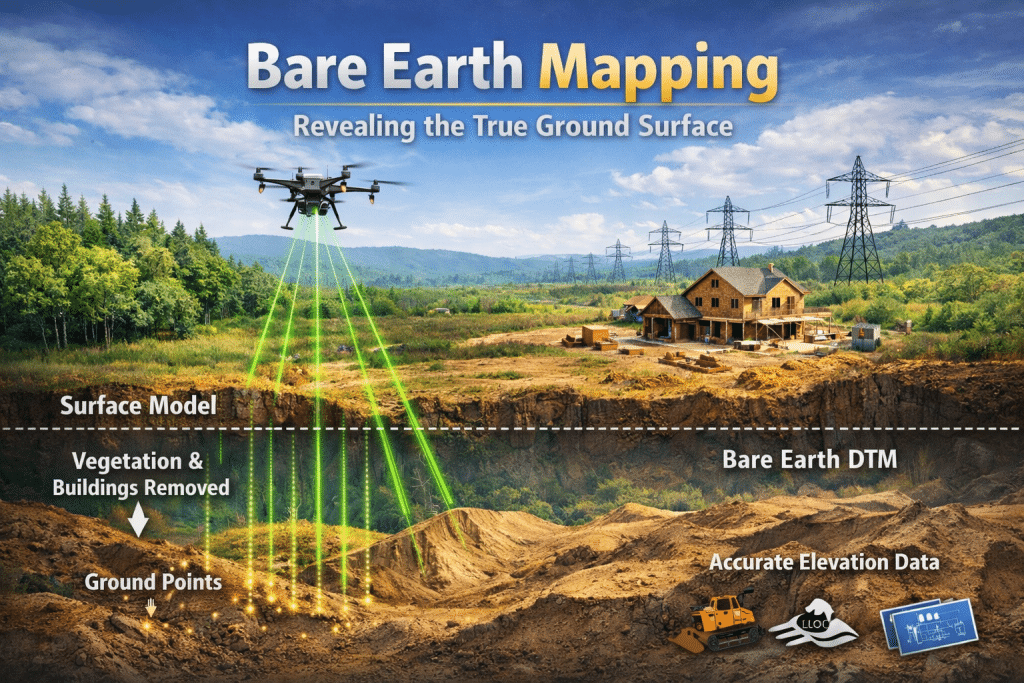
Bare earth mapping focuses on extracting the true ground surface from elevation data. It removes vegetation, buildings, and surface objects from terrain models. This allows you to see land elevation as it actually exists.
LiDAR technology plays a central role in bare earth mapping workflows. Laser pulses penetrate vegetation and return multiple elevation signals. Ground returns form the basis of accurate terrain analysis.
The result is a clear representation of land elevation without surface interference. This representation supports engineering, environmental, and infrastructure decisions. Without it, terrain data often remains misleading.
Why is surface data alone not enough?
Surface models include everything visible from above. This includes vegetation, structures, and temporary objects. Although it is useful visually, these models hide true elevation details.
When terrain data includes surface clutter, measurements become unreliable. Slopes, drainage paths, and elevation changes may appear incorrect. This creates uncertainty during the planning stages.
Bare earth mapping removes this uncertainty by isolating ground elevation only. That clarity improves confidence in every downstream decision.
How does lidar bare earth mapping work?
LiDAR sensors emit thousands of laser pulses toward the ground each second. Some pulses reflect off vegetation, while others reach the terrain surface. These multiple returns create layered elevation data.
Ground point classification separates terrain points from non ground features. Algorithms identify which returns represent true ground elevation. This step is critical for accurate results.
After classification, vegetation and structures are removed from the dataset. The remaining data represents the bare earth surface. This enables precise terrain analysis.
The role of ground point classification
Ground point classification determines which data points represent terrain accurately. It filters out vegetation and builds structures using automated processes. Accuracy here directly affects final mapping quality.
Whereas, poor classification can distort slopes and elevation profiles. This leads to incorrect assumptions during planning; and, such errors are difficult and expensive to correct later.
Accurate ground point classification ensures reliable terrain representation. It allows you to trust elevation values used for analysis. That trust is essential for decision making.
Understanding digital terrain model (DTM)
A digital terrain model DTM represents the bare earth surface digitally. It contains elevation values without vegetation or surface features. This makes it ideal for technical analysis.
DTMs support slope analysis, drainage modeling, and infrastructure design. They are widely used in environmental and engineering projects. Accuracy at this level is crucial.
Bare earth mapping forms the foundation of a reliable DTM. Without clean ground data, DTMs lose analytical value. Precision always starts at ground level.
Why terrain mapping accuracy matters
Terrain mapping accuracy directly affects how projects are designed and executed. Even small elevation errors can cause drainage or grading issues. These mistakes often lead to delays and added costs.
Accurate terrain data supports safer and more efficient planning. Designs align better with real site conditions. This reduces unexpected challenges during construction.
Bare earth mapping significantly improves terrain mapping accuracy. It removes misleading surface information. This leads to better project outcomes.
Vegetation removal lidar and its impact
Vegetation removal lidar allows ground visibility beneath dense vegetation. Forested and heavily covered areas become measurable and analyzable. This was difficult with traditional mapping methods.
Laser pulses penetrate gaps in vegetation and return ground reflections. Multiple returns reveal both canopy and terrain layers. This makes LiDAR effective in complex landscapes.
By applying vegetation removal lidar techniques, true terrain becomes visible. Ground elevation emerges accurately across sites. This supports reliable mapping results.
Learn more about UAV Drone surveying accuracy.
How bare earth mapping supports better planning
Effective planning depends on understanding terrain without visual distortion. Bare earth mapping provides consistent clarity across different environments. It removes assumptions caused by surface interference.
Engineers use terrain models to design roads, foundations, and drainage systems. Environmental teams assess flood risk and erosion patterns accurately. Reliable data prevents costly redesigns.
When planning is based on accurate terrain data, confidence increases. Decisions become data driven rather than speculative. This benefits every project stage.
Improving data quality through mapping
Data quality improves when mapping reflects actual ground conditions. Bare earth mapping eliminates distortion caused by vegetation and surface objects. This creates a cleaner dataset.
Reliable mapping supports better analysis and reporting. It reduces rework caused by incorrect assumptions. Quality data leads to better outcomes.
When data quality improves, overall project efficiency improves as well. Teams trust the information they receive. This saves time and resources.
Applications across industries
Bare earth mapping supports a wide range of industries. Construction teams use it for grading and site preparation. Environmental professionals rely on it for watershed analysis.
Infrastructure planning depends on accurate elevation data. Utilities use terrain models for corridor planning. Each application relies on precision.
LiDAR bare earth mapping adapts to diverse environments. It delivers consistent results across terrain types. That versatility makes it widely valuable.
Choosing the right mapping approach
Not all mapping methods deliver the same accuracy. Surface models may look impressive visually. However, they often hide critical terrain details.
Bare earth mapping focuses on usable and reliable data. It prioritizes accuracy over appearance. This aligns better with operational needs.
When selecting mapping services, accuracy should guide decisions. Clean terrain data matters more than visuals. That distinction is important for you.
Rekon approach to reliable terrain data
At Rekon Solutions, bare earth mapping is designed for dependable terrain analysis. The focus remains on clean ground data and consistent accuracy. This ensures outputs support confident planning and decision making.
The future of terrain mapping
Mapping technology continues advancing rapidly. LiDAR sensors are becoming more precise and efficient. Data processing methods are improving steadily.
As expectations rise, terrain accuracy becomes non-negotiable. Bare earth mapping will remain central to reliable analysis. Its importance will continue growing.
Future projects will rely heavily on clean elevation data. Accurate terrain models will guide smarter decisions. This makes bare earth mapping essential.
Frequently asked questions
How does data mapping help improve data quality?
Data mapping aligns raw data with accurate spatial representations. It removes inconsistencies and distortion. This improves reliability.
What are some benefits of using data mapping?
Data mapping improves accuracy and consistency. It supports better planning and reporting. Decisions become more reliable.
What is the importance of mapping?
Mapping provides spatial understanding of terrain and environments. It supports planning and risk assessment. Accurate mapping reduces uncertainty.
What kind of map is the most accurate?
Bare earth terrain maps are among the most accurate. They remove surface clutter completely. This reveals true ground elevation.
Moving forward with confidence
Reliable decisions begin with accurate terrain understanding. Bare earth mapping provides clarity beneath surface noise. It supports smarter decisions across industries.
When accuracy matters, clean ground data makes the difference. It reduces risk and improves outcomes. That is the true value of bare earth mapping.
If you are looking for reliable terrain mapping solutions, get a quote here or contact our team to learn how we work.