Lately, businesses are increasingly turning to technology to enhance accuracy, save time, and reduce costs.
One such innovation that has revolutionized industries like agriculture, construction, and environmental monitoring is orthomosaics.
But what exactly are orthomosaics, and why do they matter?
In this blog, we will explore the benefits, accuracy levels, and diverse applications of orthomosaics. Also, we’ll discuss how industries are leveraging this cutting-edge technology.
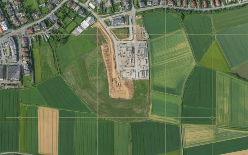
What Are Orthomosaics?
Orthomosaics, or orthomosaic maps, are high-resolution maps. They are created by stitching together aerial images. These images are corrected for distortion and provide accurate views.
Orthophotos are corrected for camera tilt, lens distortion, and terrain variations. This ensures high accuracy for mapping and measuring land. Orthomosaics are useful for large-scale, high-precision mapping.
Benefits of Orthomosaics
1. High Accuracy Levels
Orthomosaics offer exceptional accuracy for measurements and analysis. These maps use photogrammetry to create precise data. With sub-centimeter accuracy, they are ideal for tasks like land surveying and construction.
Compared to traditional methods, they provide higher precision. Orthomosaics save time and reduce errors in mapping projects.
2. Cost-Effective and Time-Saving
Creating orthomosaic maps traditionally is time-consuming and expensive. Drone-based orthomosaic services are faster and cheaper. Drones capture vast areas quickly, saving time and labor costs.
This enables businesses to get real-time, accurate results. Drone surveys cut down on repeat visits and manual measurements.
3. Versatile Applications
Orthomosaics have wide-ranging applications across many industries:
- Agriculture Mapping: Orthomosaic maps help monitor crop health and soil conditions. They help farmers detect crop stress, pest infestation, and irrigation needs. These maps improve decision-making for farming practices.
- Construction: In construction, accurate mapping is critical. Orthomosaics assist with site planning, design, and monitoring. They help contractors assess terrain, track progress, and manage risks.
- Environmental Monitoring: For environmental assessments, orthomosaics provide valuable insights. They track land use, vegetation, and disaster impact. These maps are essential for conservation and environmental protection.
- Urban Planning: City planners use orthomosaics for infrastructure development. They evaluate land usage, zoning, and future development. These maps ensure sustainable growth and planning.
Accuracy Levels in Orthomosaics
The accuracy of orthomosaics depends on factors like drone sensor quality and flight altitude. Typically, drone-based orthomosaics can achieve ground sampling distances (GSD) as low as 2.5 cm. This makes them ideal for high-precision tasks, like surveying and mapping.
High-quality sensors and GPS systems ensure highly georeferenced imagery. This gives accurate results suitable for professional use in mapping and surveying.
Industry Applications
Orthomosaics are transforming industries by providing precise mapping data. Here’s how they’re being used:
- Agriculture: Farmers use orthomosaics for crop health analysis and precision farming. These maps help optimize irrigation, fertilization, and harvesting practices.
- Urban Development: City planners and developers use orthomosaics for zoning and infrastructure planning. These maps provide detailed views of land and existing structures.
- Environmental Science: Orthomosaics are crucial for monitoring ecosystems and natural habitats. They help scientists track land changes, deforestation, and wildlife habitats.
- Disaster Response: After disasters, orthomosaics help assess damage and plan recovery efforts. They give first responders accurate, up-to-date visual data for decision-making.
FAQs
1. What is the main function of an orthomosaic map?
Orthomosaic maps provide detailed views by stitching aerial images. They are used for accurate measurements and land analysis across industries.
2. What are orthomosaics?
Orthomosaics are maps created by stitching multiple aerial images. They are georeferenced and used for precise mapping and measurements.
3. What is the accuracy of drone photogrammetry?
Drone photogrammetry can achieve sub-centimeter accuracy. This makes it ideal for tasks that need precise measurements, like surveying.
4. What types of advanced technology are used in mapmaking today?
Modern mapmaking uses drone photogrammetry, LiDAR, GPS systems, and geospatial software. These technologies ensure highly accurate and reliable maps.
Conclusion
Orthomosaics are changing the way we approach mapping. Their accuracy, cost-effectiveness, and versatility are transforming industries. By using drone orthomosaic services, businesses can access real-time, precise data for informed decision-making.
With drone technology advancing, the applications of orthomosaics will continue to grow. More industries will adopt this technology for improved efficiency and productivity.
Contact Rekon Solutions today to learn how our orthomosaic services can take your projects to the next level.
