Have you ever wondered how land surveys are done so quickly and accurately?
The secret lies in UAV drones for surveying.
These drones are changing the way surveying is done, making it faster, safer, and more accurate.
In this blog, we’ll explore why UAV drones for surveying are now the industry standard. We’ll dive into the benefits, how they work, and why industries are turning to them for land surveys.
What Are UAV Drones for Surveying?
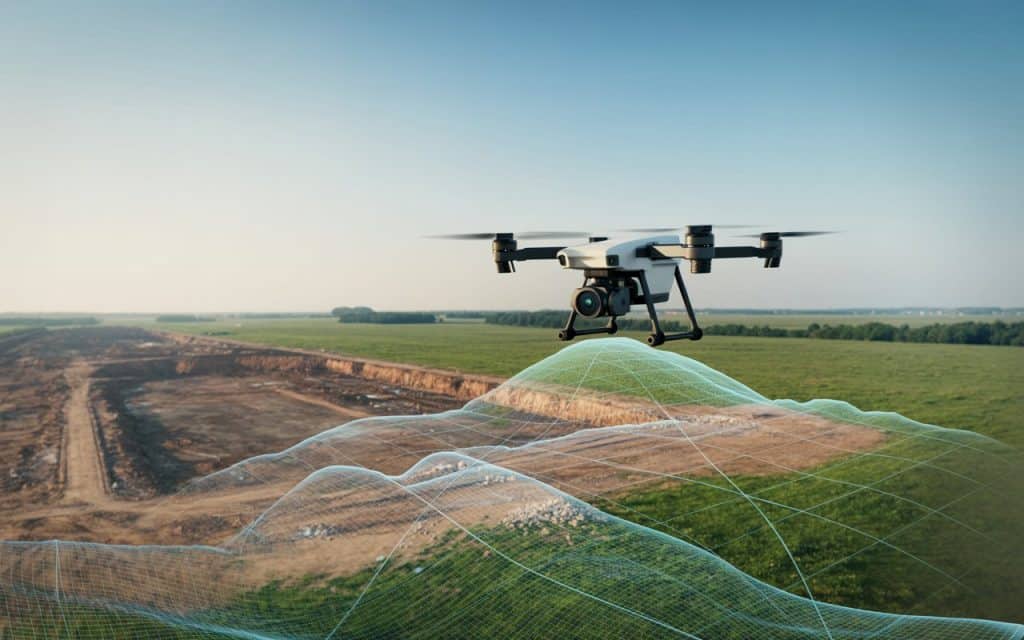
UAV drones for surveying are unmanned aerial vehicles used to gather land data. These drones are equipped with high-resolution cameras, LiDAR sensors, and GPS systems. They can quickly collect accurate data from the air.
The data captured by the drones is used to create detailed maps, 3D models, and digital terrain models. These models help in planning and decision-making for construction, agriculture, and other industries.
Why Are UAV Drones for Surveying So Popular?
1. Faster Data Collection
One of the biggest reasons for the rise of UAV drones for surveying is speed. Traditional methods took a lot of time. Surveyors had to walk the land, take measurements, and record data manually. This process was slow and labor-intensive.
With drones, large areas can be surveyed in a fraction of the time. This means projects get started sooner and finish faster.
2. Higher Accuracy
Accuracy is key in surveying. UAV drones for surveying use advanced GPS systems like RTK (Real-Time Kinematic) to capture data with centimeter-level precision.
For example, a UAV land survey using RTK technology can produce highly accurate topographic maps. This level of precision is crucial for projects that require exact measurements.
3. Cost-Effective
While drones might seem expensive at first, they save money in the long run. Traditional methods require a lot of labor and expensive equipment. Drones, on the other hand, reduce the need for large teams and costly machinery.
They also reduce the amount of time spent collecting data. Faster surveys mean fewer labor costs and faster project timelines.
4. Improved Safety
Surveying often requires workers to enter hazardous areas. Climbing tall structures, crossing unstable land, or working in difficult conditions can be risky.
With UAV drones for surveying, most of the work can be done from the ground. Drones fly over difficult or dangerous terrain, keeping workers out of harm’s way. This makes surveying safer and reduces the risk of accidents.
5. Versatility in Applications
UAV drones for surveying are used across many industries. Construction, agriculture, mining, and environmental monitoring all benefit from drone surveys. Drones can map construction sites, monitor crops, and inspect infrastructure.
For example, drone surveying applications like GIS drone mapping help farmers monitor crops. They can track soil conditions and assess irrigation needs. This makes farming more efficient and precise.
6. Real-Time Data Collection
One major benefit of drone survey technology is real-time data collection. Traditional surveys often required teams to wait days or weeks to analyze the data. Drones, however, provide immediate results.
Surveyors can see the collected data almost instantly. This allows for quick decision-making and reduces delays in projects.
7. Easier Repeat Surveys
Another advantage is that drones make it easy to repeat surveys. For example, in large construction projects, drones can be used regularly to monitor progress.
If there’s a change in the site, drones can be sent out again to capture fresh data. This makes it easy to track progress and stay on schedule without hassle.
How UAV Drones for Surveying Work
UAV drones for surveying work by flying over the land to capture data. The drone uses high-quality sensors, cameras, and GPS to gather the required data.
The data collected is then processed by software to create detailed maps and models. These models can show terrain features, vegetation, roads, and structures.
In UAV land mapping, drones capture images that overlap to create a seamless map. This ensures there are no gaps in the data, and surveyors get a complete picture of the area.
Why Are UAV Drones for Surveying the Industry Standard?
1. Real-Time Accuracy
When it comes to surveying, having accurate data is critical. UAV survey drones provide high-precision measurements. This level of accuracy is why they are so popular in industries like construction and agriculture.
RTK drone survey technology improves the accuracy of GPS systems. It ensures that the survey data is correct down to the centimeter.
2. Improved Data Processing
Drones make it easy to process data and generate reports. After a flight, the data collected by UAV drones for surveying is processed by software.
The software quickly transforms the data into digital maps and 3D models. This saves time and helps surveyors make better decisions faster.
3. Reduces Human Error
Human error can happen during traditional surveys, especially when taking manual measurements. Drones, however, remove much of this risk. Surveying with drones eliminates human error in data collection.
Drones automatically collect the necessary data, ensuring that measurements are precise and reliable. This results in more accurate maps and models, which is essential for planning projects.
4. Time-Saving Benefits
Surveyors no longer need to spend days or weeks gathering data. Drones collect the information much faster and allow for quicker analysis.
With traditional methods, surveyors often have to wait for lab results or field reports. Drones provide instant results, so teams can move forward without delays.
Industries Benefiting from UAV Drones for Surveying
1. Construction
In the construction industry, UAV drones for surveying are essential for mapping large construction sites. Drones help track construction progress and ensure that designs are followed accurately. They are also used to measure stockpiles and monitor earthworks.
By using drone surveying applications, construction teams can get precise data and avoid mistakes. This helps keep projects on schedule and within budget.
2. Agriculture
Farmers use UAV drones for surveying to monitor crops, track soil health, and measure irrigation. Drones can fly over large fields, collecting data on crop health and environmental conditions.
The data is used to make better farming decisions, which can lead to higher yields and reduced waste.
3. Mining
Mining companies rely on drones to monitor stockpiles, track the progress of excavation, and create topographic maps of mining areas. Drones provide accurate data without the need for workers to access hazardous areas.
By using UAV survey drones, mining companies can improve efficiency and safety while reducing costs.
4. Environmental Monitoring
Environmental monitoring requires accurate data to track land changes, vegetation, and wildlife habitats. Drone surveying applications are used to monitor these conditions and help with conservation efforts.
Drones help gather data from hard-to-reach areas, making it easier to assess environmental changes and protect ecosystems.
How Rekon Solutions Can Help
Rekon Solutions provides UAV drones for surveying that are perfect for various industries. Whether you need UAV land mapping or precision mapping, our expert team is here to help. We offer fast, accurate, and reliable surveying services that fit your needs.
Learn more about how UAV survey drones can help your business by checking out our previous blog on drone surveying applications.
Conclusion
UAV drones for surveying are quickly becoming the industry standard because they provide speed, accuracy, and efficiency. Drones have transformed the way surveys are conducted, making them faster, safer, and more cost-effective.
From UAV survey drones in construction to precision mapping in agriculture, drones offer a versatile and reliable solution for a wide range of industries. With real-time data collection, improved accuracy, and reduced costs, drones are the future of surveying.
If you’re ready to upgrade your surveying capabilities, Rekon Solutions is here to help. Contact us today to learn how our professional survey drones can benefit your business.
