In British Columbia, land surveying is essential. But it’s not always easy. Because the landscape is vast and varied. And, for years, traditional methods worked well, but things are changing lately. Where LiDAR BC is making surveying faster, safer, and more accurate.
Have you ever wondered how LiDAR mapping BC works or why it’s becoming so popular?
Let’s dive in and see why this technology is now a game-changer for professionals across the province.
What Is LiDAR and How Does It Work?
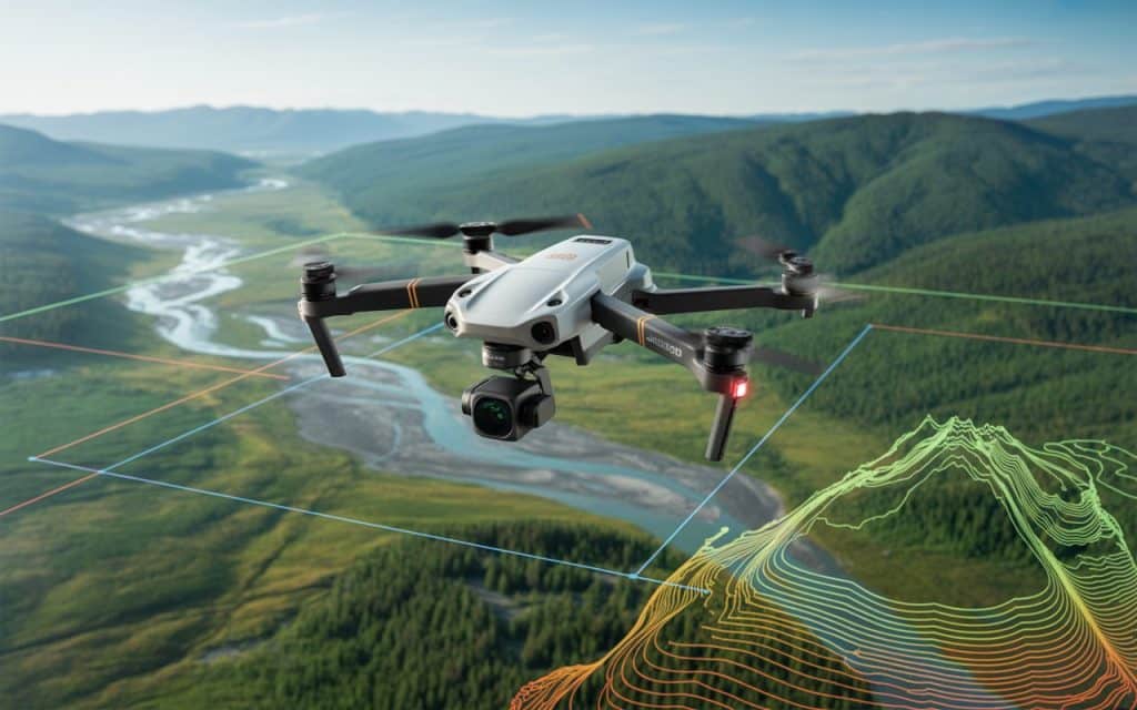
LiDAR BC is a technology that uses laser pulses to measure distances. These pulses bounce off objects, and the sensor measures how long it takes for them to return. This allows drones or aircraft to create detailed, accurate 3D models of the land.
The data can be processed into digital terrain models, surface maps, and 3D models. It’s like having a bird’s-eye view of the terrain, but with incredible detail.
Why Is LiDAR BC So Important?
1. Superior Accuracy for Terrain Mapping BC
Accuracy is key when it comes to land surveys. LiDAR BC provides measurements down to the centimeter level. This is especially important in BC, where the landscape can change quickly.
LiDAR mapping BC allows surveyors to capture every small detail. Whether it’s trees, buildings, or land contours, it gives a precise picture of the area. That’s not something traditional methods can always offer.
2. Wide Range of Applications
LiDAR BC isn’t just for one type of project. It’s versatile. From BC LiDAR surveys to forestry management, this technology helps in many industries.
In forestry, it’s used to measure tree height and canopy density. In construction, it maps land before development. For environmental monitoring, it tracks changes in terrain and vegetation.
Whether it’s for planning or monitoring, LiDAR data BC can do it all.
3. Faster Data Collection
One of the biggest perks of airborne LiDAR BC is how quickly data can be collected. Traditional surveying can take days or even weeks, depending on the area.
With drones or planes, LiDAR BC can cover large areas in just hours. The speed is a huge advantage. More data in less time means quicker decisions.
It’s a game-changer for projects that need to keep moving forward.
4. Non-Intrusive Data Collection
Unlike traditional methods, LiDAR BC doesn’t require surveyors to walk or climb dangerous terrain. Drones or aircraft do the heavy lifting.
This makes it safer. LiDAR mapping allows data collection from the sky without disturbing the environment. No need to cut down trees or navigate hazardous terrain. It’s all done from the air.
5. Cost-Effective
The initial investment in LiDAR BC might seem steep, but the return is worth it. Traditional surveying requires heavy equipment and a lot of man-hours.
Drones and UAV land surveys cut down on both. Fewer people need to be on-site. Less machinery is required.
This efficiency leads to big savings over time, even though drones and LiDAR data BC may require an upfront cost.
Regulatory Considerations When Using LiDAR BC
1. Environmental and Land Use Regulations
In BC, land use is tightly regulated. For anyone using LiDAR, it’s important to follow these rules.
Whether you’re using airborne LiDAR to monitor a forest or a construction site, there are environmental considerations. LiDAR mapping BC is commonly used for environmental assessments. But it must comply with provincial and federal regulations.
The goal is to make sure the technology is used responsibly while minimizing its impact on natural habitats. Permits may be required before conducting a survey.
2. Privacy and Legal Concerns
LiDAR may collect data over large areas, which can raise privacy concerns. When surveying near populated areas or private property, it’s essential to follow privacy laws.
In BC, drone operations must comply with the Canadian Aviation Regulations. These include restrictions on where and when drones can fly.
It’s important to get the necessary permissions and inform local authorities, especially when flying over private property or sensitive areas.
3. Permitting for Airborne LiDAR BC
Using drones for LiDAR often requires permits. When flying over public or private land, specific guidelines must be followed.
Operators must stay within controlled airspace and avoid no-fly zones. The drones must also be registered with Transport Canada if they are to be used for commercial purposes.
Regulatory compliance ensures that operations are safe and legal. It also helps maintain the integrity of the data being collected.
The Future of LiDAR BC
The demand for LiDAR is growing. As more industries recognize its value, LiDAR mapping BC is becoming a go-to tool for surveying and monitoring.
Advancements in drone technology, combined with improved sensors, are making LiDAR even more accessible and effective. More businesses in BC are beginning to see the benefits, from quicker surveys to safer, more accurate data.
In the future, LiDAR data BC will be more widely adopted. Its versatility will allow even more industries to harness its power.
The technology is poised to be the standard for industries that rely on high-quality surveying data.
Rekon Solutions: Your LiDAR Partner in BC
At Rekon Solutions, we offer LiDAR BC services designed to meet the unique needs of various industries. Our team uses state-of-the-art technology to deliver high-precision data that helps businesses make informed decisions.
We specialize in airborne LiDAR for accurate LiDAR surveys and terrain mapping. Our drones collect data efficiently, ensuring you get the best results in less time.
Contact us today to learn how we can help with your next LiDAR mapping BC project. We’re here to help you gather the most accurate, reliable data for your operations.
Check out our blog on UAV surveying to learn more about how drones are revolutionizing data collection in various industries.
Conclusion
LiDAR has quickly become an essential tool for land surveying in British Columbia. From its ability to provide precise data to its versatility across industries, LiDAR mapping is transforming how professionals approach surveying and land analysis.
Whether you’re in construction, forestry, or environmental management, LiDAR data provides you with the insights needed to plan, execute, and monitor projects efficiently. The future of surveying is clearly in the sky with airborne LiDAR, and Rekon Solutions is here to help you take full advantage of this cutting-edge technology.
Get in touch with us today to explore how our LiDAR services can improve your projects, save time, and boost accuracy.
