If you have ever doubted a stockpile number, you are not alone. Drone volume measurement accuracy is one of the first things teams want to understand before they trust the results.
The good news is that the technology has matured a great deal. Today, photogrammetry can measure piles and pits with impressive precision.
In fact, one peer reviewed study found that drone volumes matched a traditional ground survey within 0.7 percent on a pile of more than 530,000 cubic metres, and repeat flights of the same pile agreed within 0.2 percent, according to research published in Geomatica.
So how does this actually work, and what separates a number you can bank on from one you cannot? Let us walk through it together.
How drones measure volume with photogrammetry
Before we talk about accuracy, it helps to know how the number is made. A drone flies a planned grid and snaps hundreds of overlapping photos of the site.
Software then turns those photos into a detailed 3D model of the surface. This step is the photogrammetry volume calculation, and it compares the shape of the pile against a base level to work out how much material is there.
Because the drone captures the whole pile, not just a few points, the model reflects the real shape of the material. We break down how those overlapping images become measurable data in our guide on how photogrammetry builds a map from overlapping photos.
This is what makes it possible to calculate volume using drone mapping in a single short flight, even on large or awkward piles.
So how accurate are drone volume measurements really
Here is the part you came for. When the workflow is done properly, drone volume calculation accuracy typically lands within a few percent of ground truth, and often much closer.
The study mentioned above is a strong example. Its drone survey accuracy volume calculation came within 0.7 percent of the ground based result on a very large pile, and the repeat flights were even tighter.
That level of photogrammetry accuracy volume measurement is more than enough for most reporting, billing, and planning needs. For many operations, an aerial volume measurement is now as trusted as a manual one, and far faster to produce.
Still, drone volume measurement accuracy is not automatic. It depends heavily on how the survey is planned and processed.
What affects drone volume measurement accuracy?
Several things decide whether your volumes come out tight or loose. The first is ground control. Placing measured control points around the site, or flying with an RTK drone, anchors the model to real world coordinates.
Flight planning matters too. Good image overlap, a steady altitude, and clear lighting all help the software build a clean surface.
The base surface under the pile is another big factor. If the software has to guess the ground beneath the material, the volume can drift. A known base level keeps the drone surveying volume calculation honest.
Finally, the shape and texture of the pile play a role. Smooth, well formed piles are easier to measure than steep, uneven ones. We cover these accuracy drivers in more depth in our guide on how to get your surveying right with photogrammetry.
Get these right, and your volume measurement accuracy drone survey results stay consistent from one flight to the next.
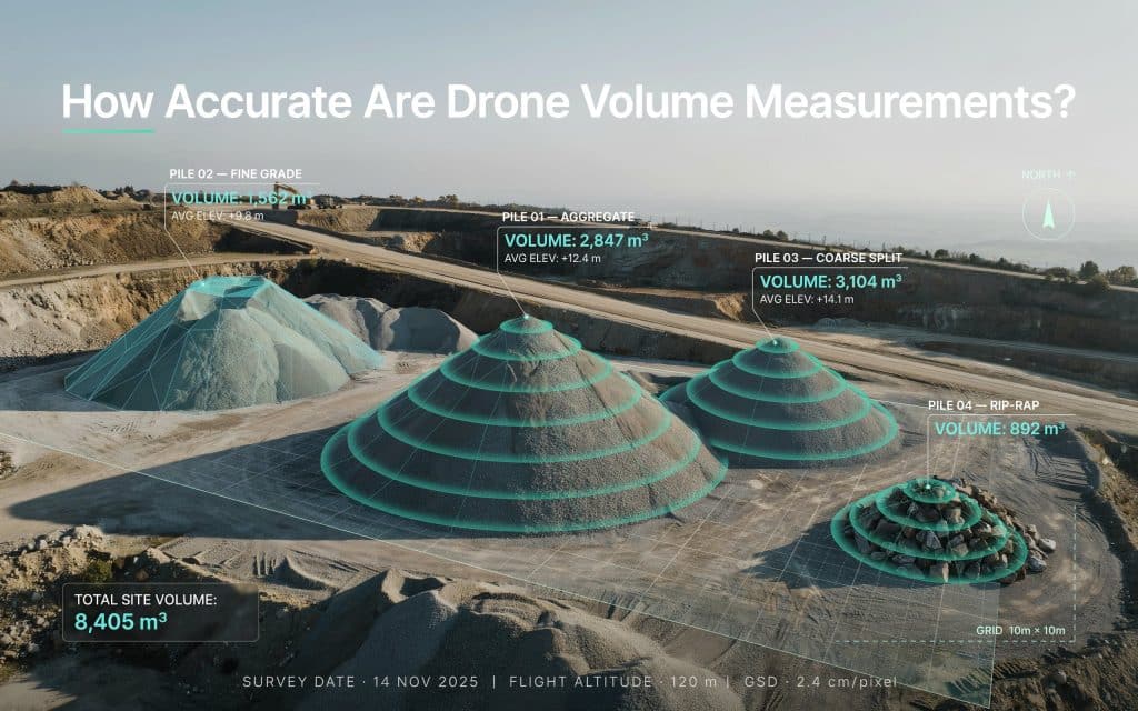
Why stockpile teams rely on drone volume numbers?
Nowhere is this more useful than on stockpiles. A single drone volume measurement can check inventory across a whole yard in one visit, with no one climbing a pile.
For quarries and mines, that speed changes how often you can measure. Monthly counts can become weekly, or even on demand. Strong drone volume measurement accuracy means those frequent checks still hold up for reporting. This is the exact problem we tackle on our page about volume discrepancies in quarry stockpiles.
A drone stockpile measurement flight can cover dozens of piles at once, and each one is measured the same way every time.
Moreover, a stockpile measurement drone also removes the guesswork from reconciliation, which is often worth as much as the raw accuracy itself.
How to get volume results you can trust?
If accurate volumes affect your bottom line, a few habits make all the difference. Use ground control or RTK on every flight that feeds a report.
Keep your flight settings consistent, so each survey can be compared fairly to the last. Set a clear base surface before you calculate, rather than letting the software assume it.
Most importantly, work with a team that treats accuracy as the goal rather than an afterthought. Rekon Solutions plans each flight around your site and your reporting needs, so your drone volume measurement accuracy holds up when it counts.
Frequently asked questions
How accurate are drone volume measurements with photogrammetry?
With proper ground control and planning, results commonly fall within a few percent of a ground survey, and often under 1 percent on large, well formed piles.
Do you need ground control points for accurate volumes?
For report grade numbers, yes. Ground control or an RTK drone anchors the model and keeps drone volume calculation accuracy consistent across surveys.
How long does a drone volume survey take?
Often a single short flight, plus processing time. A drone can measure many piles in the time a ground crew would need for just one.
Is drone volume measurement accuracy good enough for billing?
In most cases, yes. When the workflow is sound, the numbers are trusted for inventory, billing, and planning alike.
Putting Accurate Volume Data to Work for Your Site
At the end of the day, a volume number is only useful if you believe it. The reassuring part is that drone volume measurement accuracy, done well, stands shoulder to shoulder with traditional methods. In addition, it delivers those numbers faster and more safely.
The difference comes down to the workflow behind the flight. Solid control, smart planning, and careful processing turn a quick flyover into a figure you can defend in a meeting.
If your stockpile, cut and fill, or earthworks numbers need to hold up under real scrutiny, let us show you what a properly run survey can do. Reach out to share your site details, and we will help you get volumes you can act on with confidence.
