Project teams today need more than simple aerial photos. They need accurate measurements, terrain insights, and reliable models for planning and analysis.
Although traditional surveys can provide this information, still they often require more time and resources.
This is why drone photogrammetry services are becoming essential across industries.
By turning aerial images into measurable terrain models, photogrammetry creates detailed spatial data quickly and efficiently.
Moreover, it allows you to visualize sites in ways that standard surveys cannot.
If your project depends on accurate terrain information, understanding this technology can help you make smarter decisions.
Let’s explore how photogrammetry transforms drone imagery into usable 3D mapping outputs.
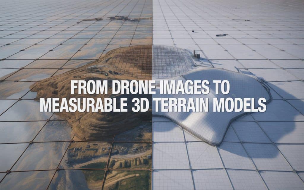
How Drone Photogrammetry Services Create 3D Terrain Models
Drone photogrammetry services work by capturing overlapping aerial images from multiple angles. Specialized software then analyzes shared points between those images. This process reconstructs the terrain into accurate digital models.
The result is known as photogrammetry 3D mapping, where images become measurable spatial data. These outputs include terrain models, orthomosaics, contours, and point clouds. Together, they provide a highly detailed representation of the project area.
Because the process relies on high image overlap, accuracy improves significantly. This makes drone mapping 3D models useful for engineering, construction, and planning workflows.
Why 3D Terrain Models Matter in Modern Projects
Modern projects require more than visual references. Teams need measurable terrain information that supports planning, design, and monitoring. This is where drone photogrammetry services provide significant value.
For example, drone 3D terrain modeling helps identify elevation changes, slopes, and drainage patterns. These details improve site preparation and reduce planning errors. Additionally, project teams can visualize terrain conditions before work begins.
This level of detail also improves communication between stakeholders. Instead of relying on technical drawings alone, teams can review realistic terrain models together.
Understanding the Role of Orthomosaic Mapping Drones
An important output of drone photogrammetry services is the orthomosaic map. These maps combine multiple corrected images into one seamless, measurable aerial image. This process is supported by orthomosaic mapping drones.
Unlike ordinary drone photos, orthomosaics maintain accurate scale and alignment. This allows you to take measurements directly from the imagery. As a result, mapping becomes both visual and analytical.
Orthomosaic outputs are especially useful for planning, inspections, and progress tracking. They provide a clear overview of large sites without distortion.
Accuracy of Photogrammetry 3D Mapping
Accuracy is one of the biggest reasons organizations adopt drone photogrammetry services. When workflows are properly planned, results can achieve centimeter-level precision.
Research published by MDPI shows that drone-based photogrammetry provides accurate terrain models of open-grown trees for construction and environmental analysis.
These studies confirm the growing reliability of drone survey 3D reconstruction workflows.
Comparing Photogrammetry vs LiDAR Accuracy
Many teams compare photogrammetry vs LiDAR accuracy before choosing a mapping method. Both technologies provide valuable data, but they perform differently depending on project conditions.
Photogrammetry excels at capturing detailed visual textures and color information. It is highly effective in open terrain where image visibility is strong. LiDAR, however, performs better in dense vegetation because laser pulses penetrate tree cover.
For many construction and infrastructure projects, drone photogrammetry services provide the right balance of accuracy and efficiency. However, some complex sites may benefit from combining both technologies.
If you want to understand how LiDAR compares with photogrammetry, you can read: Photogrammetry Vs LiDAR: Which One Wins.
Applications of UAV Photogrammetry Across Industries
You will find UAV photogrammetry applications across a wide range of industries. In construction, aerial surveys support site planning, grading analysis, and progress tracking. This improves coordination and reduces delays.
In infrastructure projects, construction site drone mapping helps monitor roads, bridges, and utilities. Teams can review site conditions remotely using updated aerial data. This improves both efficiency and decision making.
Environmental and mining sectors also benefit from photogrammetry outputs. Terrain analysis and stockpile measurements become faster and more consistent.
If you are planning a project and need accurate aerial mapping support, Rekon Solutions can help you identify the right workflow for your requirements.
How GIS Photogrammetry Data Output Supports Better Decisions
One of the biggest advantages of drone photogrammetry services is compatibility with GIS systems. GIS photogrammetry data output allows aerial mapping data to integrate directly into planning platforms.
This makes terrain information easier to analyze and share across teams. Engineers, planners, and project managers can all work from the same dataset. As a result, workflows become more connected and efficient.
GIS integration also improves long-term project monitoring. Historical aerial datasets can be compared over time to identify changes and trends.
The Workflow Behind Drone Survey 3D Reconstruction
A successful drone survey 3D reconstruction process begins with careful flight planning. Drones capture overlapping images using consistent flight paths and altitudes. Proper overlap ensures accurate reconstruction later.
The images are then processed using photogrammetry software. The system identifies matching points between images and calculates their spatial positions. This creates detailed drone mapping 3D models and terrain outputs.
Finally, the data is reviewed and validated for accuracy. Ground control points may also be used to improve alignment and positioning.
Why Construction Teams Use Drone Mapping More Frequently
Construction teams increasingly rely on drone photogrammetry services because they improve efficiency without sacrificing detail. Traditional surveys often require significant field time and manual measurements. Drone workflows reduce those requirements dramatically.
For example, construction site drone mapping allows teams to monitor progress regularly without disrupting operations. This improves project visibility and supports faster reporting.
Additionally, 3D models help identify potential site issues before construction progresses further. This reduces rework and supports better planning.
For further reading, you can also explore more aerial mapping services.
FAQs
1. What are drone photogrammetry services
These services use drones and overlapping aerial images to create measurable maps and 3D terrain models.
2. How accurate is photogrammetry 3D mapping?
With proper workflows and control points, photogrammetry 3D mapping can achieve centimeter-level accuracy.
3. What is the difference between photogrammetry and LiDAR?
Photogrammetry uses images to build models, while LiDAR uses laser pulses to capture elevation data.
4. What industries use UAV photogrammetry applications?
Construction, infrastructure, mining, environmental management, and engineering projects commonly use photogrammetry.
Final Conclusion
Modern projects demand accurate terrain data and faster decision making. Drone photogrammetry services provide a practical way to transform aerial images into measurable 3D terrain models. They improve visibility, efficiency, and planning confidence.
By integrating photogrammetry into your workflows, you gain detailed spatial information without slowing down operations. This helps teams collaborate better and make informed decisions earlier.
If you are looking for reliable aerial mapping support, Rekon Solutions can help you capture accurate data tailored to your project goals. Let us know your project details.
When mapping becomes measurable, every project decision becomes stronger.
