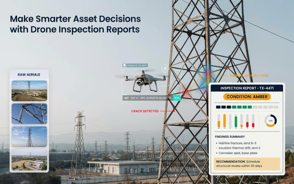
A folder full of drone photos is not the same as an answer. Strong drone inspection reporting is what turns those images into decisions your team can actually act on.
Anyone can fly a site and capture thousands of pictures. The real value shows up later, in how that data is read, organised, and explained.
Done well, reporting tells you what is wrong, how serious it is, and what to do next. Done poorly, it leaves you scrolling through endless images, still guessing.
The payoff for getting this right is real. The US Federal Highway Administration reports that Minnesota’s transportation department saw average cost savings of 40 percent on bridge inspections after adopting drones, along with better data on hard to reach elements, according to the FHWA.
So let us look at how to build reporting that works, from raw capture all the way to a clear decision.
Why do raw inspection images fall short on their own?
Pictures are easy to collect and hard to use. A single flight can produce thousands of frames, and most of them look fine at a glance.
The real problem is context. Without structure, you cannot tell which crack matters, how a defect has changed since last time, or where exactly it sits on the asset.
This is where a drone inspection report earns its keep. It takes scattered visuals and organises them into findings, locations, and severity, so the data finally means something.
Good aerial inspection reporting also creates a record you can return to. Next season, you compare today’s results and see what has moved. In short, drone inspection reporting is what turns raw capture into something useful.
What is included in a drone inspection report?
A strong report is far more than a photo dump. At minimum, it should pull together annotated images, locations, measurements, and a clear summary of findings.
Most reports include marked up images that highlight each defect, along with its exact position on the asset. They also rank issues by severity, often using a simple red, amber, and green system that anyone can read at a glance.
Many add measurements, such as crack width or corrosion area, plus recommendations for what to do next. The best visual inspection data reporting ties every finding to a decision, not just an observation.
Strong drone inspection reporting also keeps the raw data available, so an engineer can dig deeper whenever a finding needs a closer look.
How do you turn inspection images into decisions?
This is the heart of it. Capturing data is only step one, and drone inspection data analysis is what actually creates value.
First comes review, where trained eyes or software sort through the imagery and flag anything unusual. Modern image based inspection analysis can even use AI to detect cracks, rust, or missing components automatically, which speeds up the slow part of the job.
Next comes interpretation. A defect only matters in context, so drone mapping data interpretation links each finding to its location, history, and risk. We explain how raw imagery becomes measurable, mapped data in our guide on how photogrammetry builds a map from overlapping photos.
Finally, those findings become drone inspection insights, the clear takeaways that tell your team what to prioritise. That is the difference between data and a decision, and it is the core of good drone inspection reporting.
What does a strong drone inspection workflow look like?
Reliable results come from a repeatable process. A clear drone inspection workflow keeps every job consistent, from the first flight to the final report.
It usually starts with scoping. Before takeoff, you define the asset, the defects you are looking for, and the exact decision the report must support.
Then comes capture, processing, analysis, and reporting, with each step feeding the next. When the workflow is tight, your drone survey reporting stays accurate and easy to compare from one inspection to the next.
Accuracy matters at every stage, since a decision is only as good as the data behind it. We cover how to trust those numbers in our guide on how accurate drone LiDAR is for engineering and construction projects. A strong workflow is the backbone of dependable drone inspection reporting.
Frequently asked questions
How do drone inspections work?
A drone flies a planned path and captures images or sensor data of an asset. That data is then processed, analysed, and compiled into a report that supports a clear decision.
Why use drones for inspections?
They keep people out of dangerous spots, cover hard to reach areas fast, and gather consistent data every time. Strong drone inspection reporting then turns that data into action.
What industries use drone inspections?
Construction, mining, energy, utilities, and infrastructure all rely on them. Anywhere assets are large, remote, or risky to access, drones add real value.
How accurate are drone inspections?
Very, when done properly. With good capture and processing, drone data can reach centimetre level detail, and clear reporting makes that accuracy usable.
How to make your reporting drive real decisions
In the end, the goal is simple. Your inspection should leave you knowing exactly what to do next, not buried in a pile of files.
That only happens when capture, analysis, and reporting work as one connected system. Strong reporting links every image to a finding, every finding to a risk, and every risk to an action.
If you want inspection data that drives confident decisions, rather than more questions, let us help. Tell us about your assets and the calls you need to make, and Rekon Solutions will build reporting designed to answer them.