Mapping dense forests and steep mountain landscapes has always been challenging.
Thick vegetation blocks visibility, while rugged terrain limits physical access for survey teams.
These conditions often reduce the accuracy and efficiency of traditional mapping methods.
This is where lidar in forest mapping becomes a powerful solution for you.
By using laser pulses that penetrate vegetation, LiDAR captures both surface and ground data.
Moreover, it allows you to map complex environments with a level of detail that is difficult to achieve otherwise.
If your projects involve forests or mountainous regions, understanding how this technology performs can help you plan better.
Let’s break down how LiDAR handles these demanding conditions.
Why LiDAR in Forest Mapping Works in Dense Environments
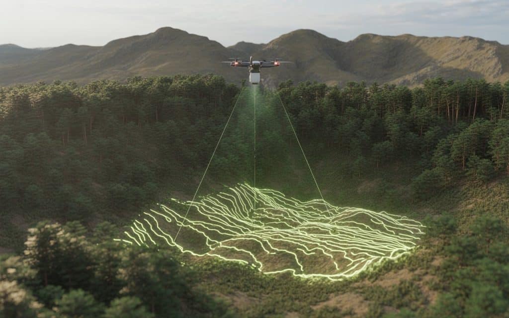
Lidar in forest mapping works by emitting laser pulses toward the ground and measuring their return time. These pulses can pass through gaps in vegetation, reaching the terrain below. This process is known as lidar forest penetration, and it is key to accurate mapping.
Unlike traditional methods, LiDAR does not rely on clear visibility from above. Instead, it collects multiple returns from different surfaces such as leaves, branches, and the ground. This allows you to separate vegetation from terrain data.
As a result, forestry lidar mapping provides both canopy and ground-level insights. This makes it highly effective for mapping dense forests.
Understanding Canopy Penetration and Ground Detection
One of the biggest advantages of lidar in forest mapping is its ability to penetrate the canopy. Canopy penetration lidar refers to how effectively laser pulses reach the ground through vegetation layers.
The system records multiple returns for each pulse. The first return may represent the canopy, while later returns capture lower vegetation and the ground. This enables accurate lidar ground detection even in dense areas.
This capability is essential for creating reliable terrain models. Without it, mapping in forested regions would remain incomplete.
How LiDAR Improves Terrain Mapping in Mountain Regions
Mountain environments present a different set of challenges. Steep slopes, uneven surfaces, and limited access make traditional surveys difficult. However, lidar terrain mapping overcomes these challenges effectively.
By capturing elevation data remotely, LiDAR eliminates the need for extensive ground access. This is particularly useful for mountain terrain mapping, where safety and accessibility are major concerns.
Additionally, LiDAR provides high-resolution elevation data. This supports accurate elevation mapping lidar outputs, even in rugged landscapes.
Accuracy of LiDAR in Dense Vegetation
Accuracy is often questioned when mapping through dense vegetation. However, lidar in forest mapping delivers reliable results when properly executed. The ability to capture multiple returns improves data quality significantly.
According to United States Geological Survey, LiDAR can accurately measure ground elevation even in heavily forested areas.
The findings confirm that lidar accuracy in dense vegetation is suitable for many engineering and environmental applications.
Applications of Forestry LiDAR Mapping
You will find forestry lidar mapping useful in many real-world scenarios. It supports forest management, biomass estimation, and environmental monitoring. By analyzing canopy structure, you can assess vegetation health and density.
It also plays a key role in vegetation mapping lidar applications. You can classify different vegetation types and track changes over time. This is valuable for conservation and land management.
In addition, LiDAR helps identify terrain features hidden beneath vegetation. This improves planning for infrastructure and development projects.
If you want to explore how mapping technologies support planning, you can read our blog here: Aerial Mapping Services: How Drone Data Supports Better Planning Decisions
Mapping Rugged Terrain with Precision
Rugged terrain requires accurate data for safe and efficient project planning. Lidar in forest mapping supports this by providing detailed elevation and slope information.
For example, rugged terrain survey projects benefit from precise measurements of elevation changes. This helps engineers design stable structures and manage risks effectively.
Similarly, slope mapping technology allows you to analyze gradients and identify potential hazards. This is critical for construction, mining, and infrastructure projects.
By combining these capabilities, LiDAR delivers a comprehensive understanding of challenging landscapes.
Limitations and Considerations
While lidar in forest mapping is highly effective, certain factors can influence performance. Extremely dense vegetation may reduce the number of pulses reaching the ground. However, advanced systems can still capture sufficient data for analysis.
Weather conditions can also affect data collection. Rain, fog, or heavy cloud cover may impact accuracy. Proper planning helps minimize these challenges.
Additionally, data processing requires expertise. Extracting accurate terrain models from LiDAR data involves specialized workflows. Working with experienced professionals ensures reliable results.
If you are planning a project in forested or mountainous terrain, you can contact Rekon Solutions to discuss how LiDAR can support your mapping needs.
Combining LiDAR with Other Mapping Methods
In some cases, combining LiDAR with other technologies improves results further. For example, photogrammetry adds visual detail to LiDAR’s elevation data. This creates a more complete dataset for analysis.
By integrating these approaches, you enhance both accuracy and usability. This is especially useful for complex projects requiring detailed insights.
FAQs
How does LiDAR work in dense forests
LiDAR uses laser pulses that pass through gaps in vegetation. This allows it to capture both canopy and ground data.
Can LiDAR detect ground under dense vegetation
Yes, lidar ground detection works by capturing multiple returns. This helps identify the ground beneath vegetation layers.
Is LiDAR accurate in mountain terrain
Yes, LiDAR provides high-resolution elevation data. It is highly effective for mountain terrain mapping.
What industries use forestry LiDAR mapping
Forestry, construction, mining, and environmental management all benefit from LiDAR mapping.
Moving Forward with Better Terrain Mapping
Mapping dense forests and rugged terrain no longer needs to be a limitation. Lidar in forest mapping provides the detail and accuracy required for modern projects. It helps you understand both vegetation and terrain clearly.
By using LiDAR, you improve safety, efficiency, and data reliability. This supports better planning and decision making across industries.
If your project requires accurate mapping in challenging environments, contact us at Rekon Solutions so you can achieve reliable results.
When terrain becomes complex, the right technology makes all the difference.
