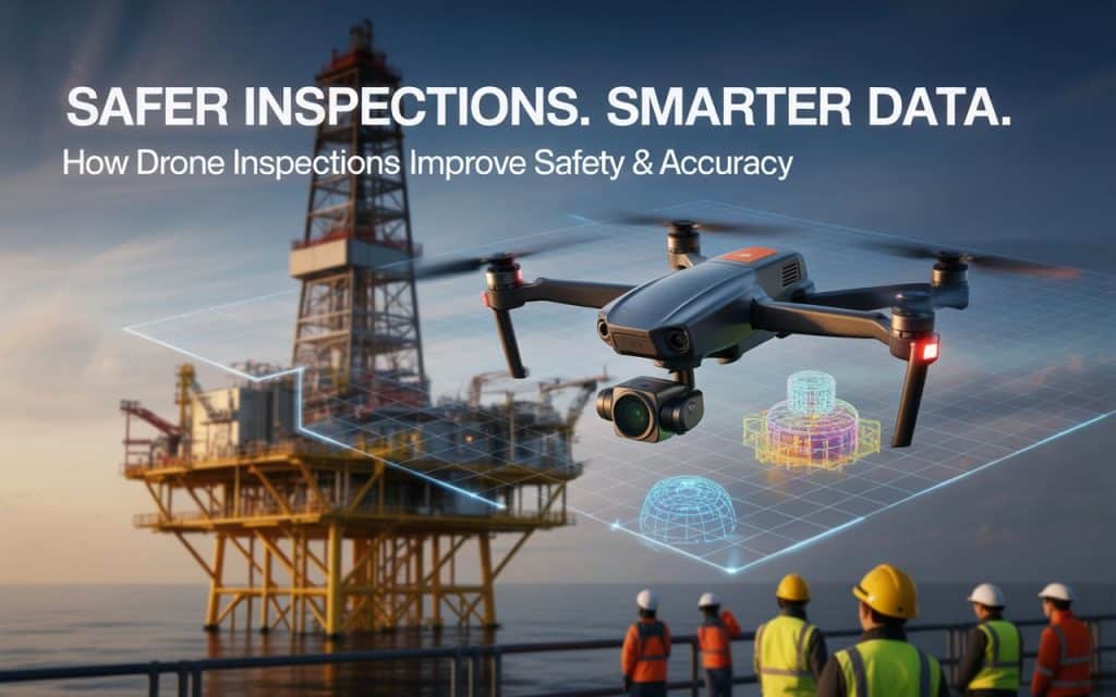
Imagine being tasked with inspecting a high-rise building or an oil rig—places that are difficult to access, full of potential hazards.
Traditionally, inspectors would have to scale heights, enter confined spaces, or work in hazardous environments to gather essential data.
These conditions make inspections not only time-consuming but also risky.
Industrial drone inspections are changing the game. By using drones to collect data remotely, industries can now complete inspections faster, more safely, and with higher precision.
This revolutionary approach to LiDAR asset inspection and infrastructure inspection drones has increased operational efficiency and greatly reduced risk.
In this blog, we’ll explore how drone inspections improve safety and accuracy, offering a glimpse into their growing role in industries such as construction, energy, and manufacturing.
Plus, we’ll cover how inspection data reporting and risk reduction with drones are driving smarter decisions.
The Power of Drones in Industrial Inspections
Drone inspections have gained widespread adoption in the last decade, thanks to their ability to access hard-to-reach places quickly and safely.
Whether inspecting a wind turbine, a building facade, or an oil pipeline, industrial drone inspections provide an efficient way to gather high-quality data. You hit your targets without putting inspectors in dangerous situations.
When traditional inspections require workers to use scaffolding, ropes, or ladders, drones take over, flying to locations and capturing detailed imagery and videos. These drones can be equipped with high-definition cameras, thermal sensors, and LiDAR (Light Detection and Ranging) technology for even more precise data capture.
Several studies confirm that drones greatly reduce inspection errors, help companies finish inspections on time and improve workplace safety by eliminating the dangerous terrain inspection people have to do.
This incredible time-saving capability allows businesses to complete more inspections in a shorter amount of time, reducing costs and improving safety. Let’s dive deeper into how drone inspections work and how they enhance safety and accuracy in real-world scenarios.
How Drones Enhance Safety in Industrial Inspections
Safety is one of the most compelling reasons to use drones in industrial inspections. In industries like construction, oil and gas, and utilities, workers are often required to access high-risk areas such as confined spaces, high structures, or hazardous environments.
With confined space inspections, workers previously had to enter cramped or dangerous areas, such as tanks or ducts, to assess conditions. This not only exposed them to potential harm but also slowed down the process.
Drones change this by allowing inspectors to gather the necessary data without entering these spaces.
For instance, drones can fly through ventilation shafts, access oil tanks, or inspect the roofs of tall buildings, capturing high-resolution imagery without exposing workers to risk.
This not only reduces accidents but also helps companies comply with safety regulations, which is critical in high-risk industries.
The Role of Drones in Improving Accuracy
Another major benefit of industrial drone inspections is the enhanced accuracy they bring to data collection.
Unlike traditional manual inspections, which are prone to human error, drones are equipped with precise GPS systems and sensors that capture highly accurate data.
Drones can be equipped with thermal cameras to detect heat anomalies or LiDAR sensors for precise elevation measurements, giving inspectors more detailed and reliable data. This data is then used for accurate reporting, which supports better decision-making for maintenance, repairs, and upgrades.
The ability to capture high-resolution terrain data and bathymetric data (underwater mapping data) further boosts the precision of drone inspections.
Drones capture comprehensive, multi-angle imagery that is processed into 3D models and orthomosaics, giving teams a more accurate picture of their infrastructure.
This level of detail and precision is crucial for industries like energy, construction, and utilities, where accurate data is essential for preventing failures and ensuring operational efficiency.
As a result, companies can save time and money by addressing potential issues before they escalate.
Data Reporting and Analysis Made Easy
After completing a drone inspection, the next critical step is inspection data reporting. With drones, this process becomes more streamlined and efficient. The data collected by drones can be automatically uploaded to a cloud-based platform for analysis.
Inspection data is then processed using specialized software, which converts raw footage into actionable insights. These reports are far more detailed than those generated by traditional methods, allowing teams to identify issues such as cracks, corrosion, or electrical malfunctions.
In industries such as construction and infrastructure, detailed inspection data helps businesses make informed decisions about maintenance schedules, repairs, and replacements. This reduces downtime and keeps operations running smoothly.
By providing clear, high-resolution images and 3D models, drone inspections make data reporting simpler and more effective, resulting in more informed decisions and better asset management.
LiDAR Asset Inspection and Risk Reduction
One of the most valuable aspects of LiDAR asset inspection is its ability to reduce risk in the inspection process. Whether it’s inspecting power lines, wind turbines, or buildings, drones can access dangerous areas without putting workers in harm’s way.
For instance, powerline inspections traditionally required workers to climb utility poles or use helicopters, both of which carry significant risks. With drones, the risk of worker injury is minimized, and inspections can be conducted quickly without disrupting the power grid.
By enabling more frequent and safer inspections, drones help prevent accidents and failures. Risk reduction with drones means identifying problems before they become serious. It ensures that assets stay in good condition and minimizes the likelihood of costly emergencies.
This ability to proactively identify maintenance needs and mitigate potential risks is a major benefit for industries that rely on complex infrastructure. The industries include oil and gas, telecommunications, and transportation.
How Drone Inspections are Revolutionizing Industries
Drones are revolutionizing the way inspections are performed across various sectors. From infrastructure inspection drones to asset inspection by LiDAR, the benefits are clear. Drones increase safety, provide more accurate data, reduce operational downtime, and ultimately save money.
In industries such as construction, energy, and manufacturing, drones have become indispensable tools for monitoring the condition of critical infrastructure. Companies can reduce the cost of hiring ground crews, avoid safety incidents, and perform regular inspections with ease.
For more on how drones are changing the inspection landscape, check out our previous blog on The Value of Aerial Inspections for Infrastructure Projects
FAQs
How is photogrammetry used in surveying?
Photogrammetry is used to capture detailed 3D models and maps of the surveyed area. Drones take overlapping images of the terrain, which are then processed into models that provide precise measurements.
How accurate is photogrammetry?
Photogrammetry can achieve sub-centimeter accuracy when paired with ground control points and high-resolution sensors, making it ideal for precision mapping.
How to improve photogrammetry quality?
To improve quality, ensure proper overlap of images, use high-quality cameras, maintain consistent flight speed, and incorporate ground control points to calibrate measurements.
Is LiDAR or photogrammetry more accurate?
While both technologies are highly accurate, LiDAR is typically preferred for elevation mapping and when working in areas with dense vegetation. Photogrammetry excels in visual mapping, especially in open or clear terrain.
Moving Forward with Confidence
With the rapid advancements in drone technology, the future of industrial drone inspections is brighter than ever. From confined space inspections to asset inspection by LiDAR, drones offer increased safety, accuracy, and efficiency. The data provided by drones helps businesses reduce risks, make smarter decisions, and save valuable time and money.
If you’re ready to take your inspection processes to the next level, contact our team to learn how Rekon’s LiDAR inspection services can help you achieve your goals.
