Surveying has always been about gathering accurate information.
The challenge is that collecting that information often takes significant time, effort, and resources, especially across large or difficult sites.
Today, that process looks very different.
With drone photography for surveying, teams can capture detailed site data from the air in a matter of hours instead of days. It creates a faster and more efficient approach to modern surveying.
This shift is not simply about replacing boots on the ground.
It is about giving surveyors better visibility, safer access, and more complete datasets that support better decisions throughout a project.
According to McKinsey & Company, commercial drone applications could generate between $31 billion and $46 billion in economic impact annually, with surveying and mapping among the fastest-growing professional uses.
So what exactly is driving this change, and why are more project teams incorporating drones into their surveying workflows?
Why Traditional Surveying Can Slow Projects Down
Traditional surveying methods remain valuable and necessary in many situations. However, collecting measurements point by point across large areas can be time consuming.
The challenge becomes even greater when terrain is steep, heavily vegetated, or difficult to access safely. Survey crews often need additional time, equipment, and personnel to gather the required information.
As project schedules become tighter and sites become larger, organizations are looking for ways to collect accurate data more efficiently.
How Drone Photography Fits Into Modern Surveying
At its core, drone photography for surveying uses carefully planned flight paths to capture hundreds or even thousands of overlapping photographs.
Those images are processed using photogrammetry software to create detailed maps, elevation models, and three-dimensional representations of the terrain.
Instead of recording individual survey points one at a time, drones capture an entire site in a single coordinated workflow.
This dramatically reduces field time while providing a much broader view of site conditions.
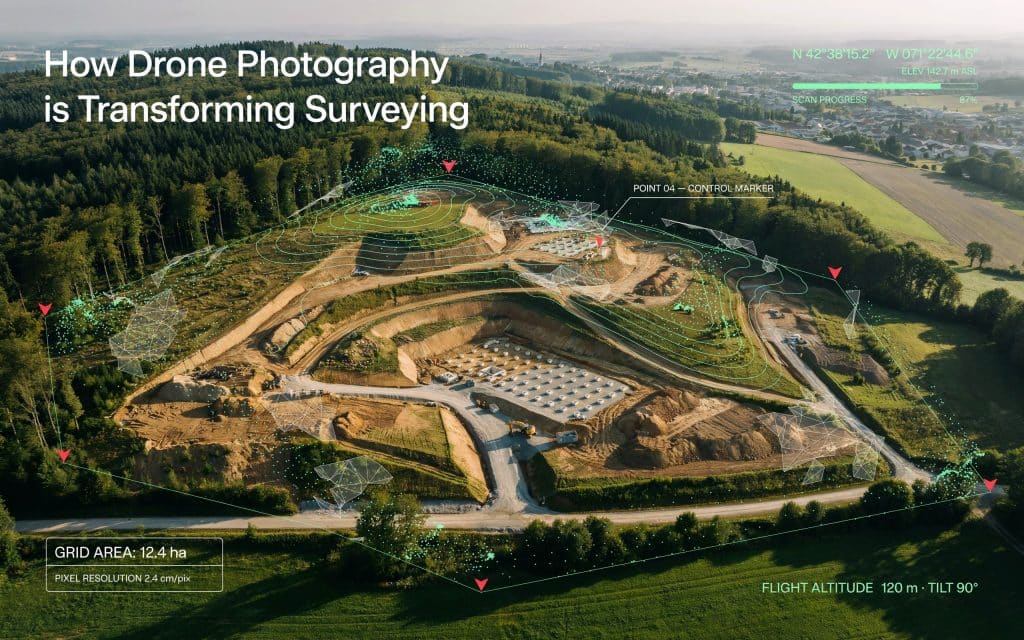
What Makes Survey Grade Drone Imagery So Valuable
Speed is important, but accuracy matters even more.
Modern survey grade drone imagery can achieve centimetre-level accuracy when supported by proper flight planning, control points, and processing workflows.
From a single mission, surveyors can generate:
- Orthomosaic maps
- Surface models
- Contour maps
- Volume calculations
- Progress documentation
- Site condition records
Perhaps most importantly, every image becomes part of a permanent visual record that can be reviewed long after the flight is complete.
Where Aerial Photography Surveying Creates the Biggest Benefits
Different industries use drone technology in different ways. However, the benefits often come back to the same core advantages: speed, safety, and visibility.
1. Construction and Development
Construction teams use aerial photography surveying to understand site conditions before work begins and to track progress throughout the project lifecycle.
Frequent flights provide updated site information that helps keep stakeholders aligned and reduces the risk of working from outdated data.
2. Mining and Resource Projects
Remote sites often present logistical challenges for traditional field crews.
Drones make it possible to capture large areas quickly while reducing the amount of time personnel spend navigating difficult terrain.
This supports planning, stockpile management, and ongoing operational monitoring.
3. Environmental Monitoring
Environmental projects often require repeatable data collection over extended periods.
Drone imagery helps teams monitor erosion, vegetation changes, watershed conditions, and land use impacts without disturbing the surrounding environment.
How UAV Photography Mapping Improves Safety
Safety is often discussed as a secondary benefit of drones, but for many projects it becomes one of the most important advantages.
Certain locations expose survey crews to risks such as unstable slopes, active construction zones, water crossings, or difficult terrain.
With UAV photography mapping, much of that information can be collected remotely while personnel remain in safer locations.
The drone performs the site access while the survey team focuses on data quality and project objectives.
Why Drone Data Capture Is Becoming Standard Practice
Several factors have accelerated adoption in recent years.
Drone technology continues to improve. Cameras capture more detail, batteries support longer flight times, and processing software delivers increasingly sophisticated outputs.
At the same time, project owners are demanding faster access to accurate information.
The result is a growing reliance on drone data capture as part of everyday surveying operations rather than as a specialized service.
If you want the data to hold up under real planning, the workflow matters, and our article on how to get your surveying right with photogrammetry walks through it.
How Drone Photography Works Alongside Other Survey Methods
One common misconception is that drones replace every other survey technology.
In reality, drones are most effective when integrated with other modern surveying tools.
For example, photogrammetry performs exceptionally well on open terrain where imagery can clearly capture surface features.
However, dense vegetation may require LiDAR to accurately measure the ground beneath the canopy.
That is why many projects combine multiple technologies to achieve the best possible outcome.
You may also find value in reading How Photogrammetry Builds a Map From Overlapping Photos to better understand how aerial imagery becomes measurable survey data.
What Should You Look for in a Survey Provider?
Technology alone does not guarantee accurate results.
Flight planning, control point placement, processing workflows, and quality assurance all influence the final deliverables.
An experienced provider understands how site conditions affect data quality and selects the right workflow for the project rather than relying on a single approach.
That expertise is often what separates useful data from data that supports confident decision-making.
If you are evaluating surveying options for an upcoming project, Rekon Solutions can help determine the most effective approach based on your site conditions, objectives, and accuracy requirements.Get in touch with our team here.
Frequently Asked Questions
1. How accurate is drone photography for surveying?
With proper planning and control, drone surveys can achieve centimetre-level accuracy suitable for many surveying and mapping applications.
2. Is drone surveying faster than traditional surveying?
In many cases, yes. Drones can capture large areas in a few hours that may otherwise require several days of fieldwork.
3. Can drones survey difficult terrain?
Yes. Drones are particularly effective in areas that are steep, remote, or challenging to access safely.
4. Does drone photography replace LiDAR?
Not always. Drone imagery and LiDAR serve different purposes and are often used together depending on project requirements.
Why Drone Photography Continues to Transform Surveying
Surveying is ultimately about making informed decisions using reliable information.
Drone photography for surveying helps teams collect that information faster, more safely, and with greater visibility than many traditional approaches alone.
As projects become more complex and timelines continue to tighten, access to accurate site data becomes increasingly valuable.
Organizations that adopt modern surveying workflows are not simply collecting data more efficiently. They are improving how projects are planned, monitored, and delivered from start to finish.
If you are looking to improve accuracy while reducing field time, drone-based surveying has become an increasingly practical place to start. Reach out with your project details to get started today.
