Have you ever wondered how professionals measure and map the Earth’s surface with such precision?
The answer is LiDAR (Light Detection and Ranging).
LiDAR services in Canada are becoming more and more popular as industries recognize how valuable they are.
But why is the demand for these services growing so fast?
Let’s take a look at where LiDAR mapping BC and 3D LiDAR scanning are used and why they are becoming so important.
What Is LiDAR and How Does It Work?
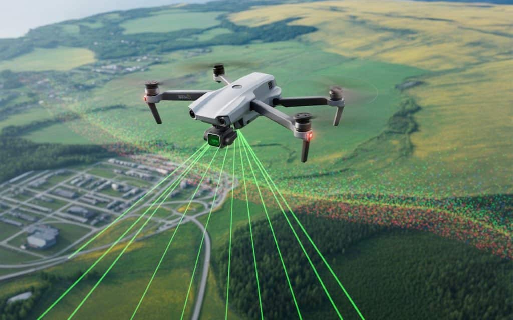
LiDAR, which stands for Light Detection and Ranging, is a technology used to measure distances by sending laser pulses and measuring the time it takes for them to return. These laser beams create detailed 3D models of the environment, capturing everything from trees to buildings.
LiDAR data is used in the form of LiDAR point clouds, which are dense collections of points that represent the surface of objects. Topographic LiDAR surveys create highly detailed maps that help professionals better understand the layout and terrain of an area.
Where Is LiDAR Used in Canada?
1. Infrastructure LiDAR
One of the main areas where LiDAR services in Canada are used is infrastructure LiDAR. It’s crucial for mapping and analyzing infrastructure projects, including roads, bridges, and buildings. With LiDAR mapping in BC, cities and provinces can accurately measure their existing infrastructure, plan improvements, and carry out repairs.
2. Forestry and Environmental Monitoring
LiDAR is also essential in forestry and environmental monitoring in Canada. LiDAR mapping BC helps measure tree heights, forest density, and canopy cover, which are crucial for sustainable forest management. It’s also used for monitoring wildlife habitats and assessing the effects of climate change.
3. Mining and Land Development
In mining and land development, LiDAR services in Canada offer highly accurate data that’s needed for planning, design, and excavation. LiDAR allows surveyors and engineers to create precise 3D models of mining sites or undeveloped land.
Afterward, this data can be used to assess materials and land, providing better planning for land development. As a result, LiDAR technology helps businesses make smarter, more cost-effective decisions when it comes to resource management and land development.
4. Agriculture and Crop Monitoring
LiDAR mapping BC is also used in agriculture to help farmers monitor crop health, evaluate soil conditions, and track irrigation. Drones equipped with LiDAR can capture high-resolution images of farms, offering insights into potential issues like pest infestations or nutrient deficiencies.
Multiple studies have shown that using LiDAR technology in agriculture improves crop yields by offering detailed data on soil and crop conditions (1) , (2). This means farmers can make decisions that increase efficiency and reduce waste.
5. Urban Planning and City Modeling
LiDAR is often used in urban planning to map cities and their surroundings. Cities like Toronto and Vancouver use LiDAR services in Canada to create 3D models of their urban environments. This data helps with everything from zoning to planning public spaces, ensuring that new developments have the least environmental impact.
By using 3D LiDAR scanning, urban planners can visualize how buildings, roads, and other structures will fit into the city. This is crucial for maintaining sustainable development in growing urban areas.
Why Is Demand for LiDAR Services in Canada Growing?
1. Increased Accuracy and Efficiency
LiDAR is far more accurate than traditional methods of surveying. For instance, traditional surveys often take longer and can be prone to human error. LiDAR, however, is much quicker, more precise, and can cover larger areas in less time. As a result, more businesses and industries are adopting it.
2. Cost-Effectiveness
While the initial cost of using LiDAR services in Canada may seem high, the long-term savings are significant. By reducing the need for field workers, travel costs, and equipment, LiDAR is an efficient choice for many businesses. The efficiency and accuracy it provides result in fewer mistakes and costly delays.
3. Advancements in Drone Technology
Another reason why LiDAR services in Canada are in high demand is the rapid growth of drone technology. Drones equipped with LiDAR sensors can quickly cover large areas and provide detailed data. This makes LiDAR technology more accessible, especially for industries that need to capture data in remote or hard-to-reach areas.
Additionally, drones are much cheaper to operate than manned aircraft, which has made LiDAR services available to a wider range of businesses and industries in Canada.
4. Government and Environmental Regulations
As Canada continues to prioritize environmental conservation and sustainable development, more industries are turning to LiDAR technology to meet regulatory requirements. LiDAR helps businesses collect the detailed data they need to comply with environmental assessments, ensuring that projects are in line with government regulations.
For example, environmental LiDAR is used by the Canadian government to monitor forest cover, flood risks, and habitat changes. As government regulations become stricter, businesses are increasingly relying on LiDAR to help them meet these demands.
Rekon Solutions: Your LiDAR Partner in Canada
As demand for LiDAR services in Canada continues to rise, Rekon Solutions is ready to provide you with the most accurate, efficient, and cost-effective LiDAR solutions. Whether you’re in construction, forestry, agriculture, or urban planning, we offer 3D LiDAR scanning and topographic LiDAR surveys to help you make more informed decisions.
To see how LiDAR technology can benefit your business, check out how LiDAR is revolutionizing industries.
Conclusion
LiDAR is quickly becoming a key tool for data collection and mapping in Canada. From LiDAR mapping BC to infrastructure LiDAR, the technology is essential for a variety of industries. The demand for LiDAR services in Canada will only continue to grow, with businesses and government agencies turning to LiDAR for its speed, accuracy, and cost-effectiveness.
If you’re looking to improve your data collection and mapping with LiDAR services, Rekon’s LiDAR drones can help you. Get in touch to learn how our 3D LiDAR scanning and topographic LiDAR surveys can help your business achieve its goals.
