Picking between drone lidar vs traditional surveying can be tricky. And the wrong choice can cost you weeks.
Both methods can give great results. But they work best in very different places.
When you match the method to the site, you save time and money. You also avoid paying for data you cannot really use.
So this guide will not just pick a winner. It will show you when each one is the smart choice for your project.
What drone LiDAR and traditional surveying each do well
First, let us see how each one works.
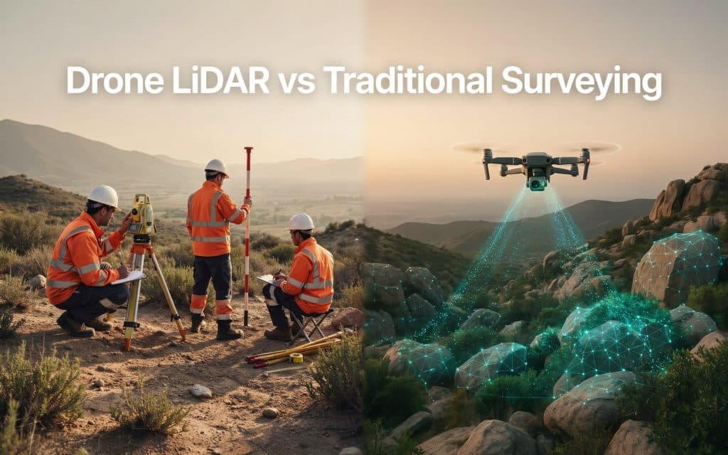
A drone lidar survey shoots fast laser beams from the sky. It measures how long each beam takes to bounce back. Those beams build a thick cloud of points that maps the ground. A lidar land survey can even map land hidden under trees.
Traditional land surveying works the other way. A crew walks the site with ground tools and marks points one at a time. These conventional survey methods have been trusted for many years. They still work great in the right job.
That is the heart of the drone lidar vs traditional surveying question. It is not about which tool is newer. It is about which one your project really needs.
Choose drone LiDAR when terrain and access are hard
Some sites are just hard on people. Steep hills, thick bushes, and far away land slow a crew down. They can also be risky.
This is where drone lidar vs traditional surveying leans toward the sky. A drone flying above can reach ground that would take days to cover on foot.
The amount of data is huge. In fact, no ground crew can match that by hand.
In one study, a drone sensor collected about 1.2 million points every second. It even mapped a creek hidden by trees, where normal photos could not see the banks at all. You can read this in the ISPRS Archives.
LiDAR is also strong in thick forests and tall mountains. Its beams slip through small gaps in the leaves to reach the ground. We explain this more in our post on how LiDAR performs in dense forest and mountain terrain.
For big areas, long roads, or any place you do not want to send a person, lidar mapping technology usually wins on speed and safety.
Keep traditional land surveying when legal lines must be exact
It is easy to think LiDAR always wins. But that is not true.
Some jobs still need ground surveying methods. Legal land lines are the best example.
When a property line or land title must be official, you need a licensed surveyor. A manual land survey carries legal weight that drone data alone does not.
Small, simple lots can also fit the old way better. If you only need a few exact points on one lot, a drone may add cost and extra work for no real gain.
So the modern vs traditional surveying choice is often about rules and size, not just speed. Knowing when to use the proven method is smart, not old fashioned. This is a part of the drone lidar vs traditional surveying talk that people often skip.
How to choose the right method for your project
Most real projects sit somewhere in the middle. A few simple questions can settle the drone lidar vs traditional surveying choice.
Start with the land. If it is steep, far, or covered in trees, the drone is usually the better pick.
Next, think about size. Big or long sites reward the speed of one flight.
Then think about what you need at the end. For official boundaries, use a surveyor. For a full map, ground shapes, or volume counts, a drone lidar survey is the better tool.
Worried about accuracy? The gap is smaller than most people think. We cover this in how accurate drone LiDAR is for engineering and construction projects.
Last, look at your time and money together. The fastest way is not always the cheapest once the data is processed.
In fact, many teams stop treating this as drone lidar vs traditional surveying. They use both. The drone maps most of the site fast. Then a surveyor checks the few points that need legal proof. In British Columbia, where land can run from valleys to mountains, this mix often works best.
Frequently asked questions
1. Is drone LiDAR more accurate than traditional land surveying?
For land shape and terrain, a good drone lidar survey can be correct to within a centimetre. That is close to ground methods. But for official legal lines, a licensed surveyor is still needed.
2. Which method is faster for a large site?
Drone LiDAR, by far. It can map in hours what a crew might need days to cover on foot.
3. When is traditional surveying still the better choice?
When the job needs legal proof, like property lines and titles. Small, simple lots can also be a good fit for conventional survey methods.
4. Can you use both methods on one project?
Yes, and many teams do. The drone covers the wide land, and a surveyor locks in the legal points. So the lidar vs traditional survey choice often ends in a smart mix.
How you can make the right call for your next survey
The best move is not to pick a side before you look at the work.
Look at your land, your goal, and your deadline. Then choose the method that fits.
If your site is steep, wooded, or very large, the drone lidar vs traditional surveying math usually points to flying. If a legal boundary is on the line, keep a licensed surveyor on the team. And when the job pulls both ways, use both.
Still staring at a map and unsure? That is exactly the time to ask before you spend a dollar.
Send Rekon Solutions a few details about your site and your goals here. You will get a clear, honest answer on the best method, with no charge for data you do not need. Choose well early, and your whole project runs smoother.
