Mapping the bottom of a river or lake once meant a boat, a sonar unit, and a lot of slow passes.
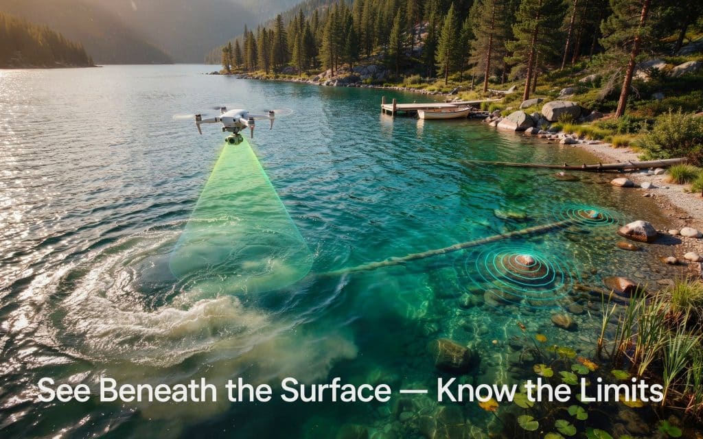
A bathymetric survey drone changes that picture.
From the air, it can read the shape of the bed beneath shallow, clear water in a single flight.
No boat ramp, and no crew out on the water.
This opens the door to faster, safer surveys of shorelines, channels, and crossings.
But it is not magic, and its limits matter as much as its strengths.
So let us look at what a drone can map below the surface, and what it can quietly miss.
What bathymetry maps?
Bathymetry is the study of underwater depth and the shape of the bed below. Think of it as topography, but for the part hidden under water.
A bathymetry mapping project turns those depths into a clear picture of the bottom. You see channels, drop offs, sandbars, and holes that you could never spot from the surface.
For rivers and lakes, that picture supports flood planning, habitat work, dredging, and bridge design. Today, a bathymetric survey drone can build it faster than older methods ever could.
How does drone bathymetry work?
A bathymetric survey drone usually carries a green laser sensor. Green light passes through clear water, bounces off the bed, and returns to the sensor.
The system times each pulse to work out the depth. This is one of the newer underwater mapping techniques, and it pairs neatly with normal land scanning in the same flight.
Older bathymetry survey methods rely on boats with sonar. They work well in deep or murky water but are slow in the shallows. Traditional hydrographic survey methods also need safe water access, which is not always possible on a fast river.
By contrast, drone water depth measurement covers shallow edges and braided channels quickly, with the crew safe on the bank. That makes aerial water depth mapping a strong fit for the tricky zone where land meets water.
What can you map with a bathymetric survey?
In the right conditions, the results are impressive. A bathymetric survey can capture the bed in fine detail wherever the water is clear and calm.
How deep can it see?
In clear water, green laser systems can reach roughly two to three times the Secchi depth, with vertical accuracy near 10 centimetres, according to Hydro International. The Secchi depth is simply how far down you can see a marker before it vanishes.
This makes a river bathymetry survey ideal for mapping channels, gravel bars, and bank erosion. A lake bathymetry mapping flight can chart shallow shorelines, inlets, and submerged features in one pass.
Because a bathymetric survey drone records land and shallow water together, you get a seamless model from dry ground to the river bed. That single, connected dataset is the real strength of an aerial bathymetric survey.
What you might miss
Now for the honest part. The water has to cooperate, and it often does not.
Cloudy or muddy water stops the laser fast. One government study found that depth penetration dropped from about 7 metres in clear water to roughly 3 metres in turbid water, according to Caltrans.
Whitewater and rapids are another blind spot. Foam and broken surfaces scatter the light, so fast, churning sections often go unmapped.
Deep water is a limit too. Below the laser reach, a bathymetric survey drone simply cannot see the bottom, and you need sonar instead. Thick weed, algae, and heavy shade can also hide the bed.
Choosing the right method
So which tool should you use? It comes down to the water and the goal.
For shallow, clear rivers and lake edges, a bathymetric survey drone is hard to beat on speed and safety. For deep, murky, or open water, sonar from a boat still wins.
Many projects use both. The drone maps the shallows and shoreline, while sonar handles the deep middle. Together they give full coverage with no risky wading.
Accuracy still depends on planning and processing, the same way it does on land. We explain those accuracy drivers in our guide on how accurate drone LiDAR is for engineering and construction projects.
In addition, you can also learn about how LiDAR copes with rugged sites in how LiDAR performs in dense forest and mountain terrain.
If you are weighing your options, Rekon Solutions can help you match the method to your water and your goals. Contact us with your project details.
Frequently asked questions
What are the key features of a bathymetric map?
A bathymetric map shows water depth and the shape of the bed. Key features include depth contours, colour shading for depth, and submerged shapes like channels, bars, and holes.
What is bathymetry mapping?
Bathymetry mapping is the process of measuring underwater depth and turning it into a map of the bottom. It works like topography for the area beneath the water, and a drone with a green laser is one fast way to collect that data.
What do the colours on a bathymetry map mean?
Colours usually show depth. Lighter shades, often blue or green, mark shallow water, while darker shades mark deeper water. A legend tells you the exact range for each colour.
How do you read a bathymetry map?
Start with the legend to learn the depth colours and the contour spacing. Closely spaced lines mean a steep drop, while wide spacing means a gentle slope.
Map your water with confidence
Bathymetry from the air is a powerful tool, as long as you respect the water. In clear, shallow rivers and lakes, a bathymetric survey drone delivers fast, detailed depth data that would take a boat crew far longer to gather.
The trick is knowing where it shines and where sonar should take over. Match the method to the conditions, and you end up with a complete, reliable picture of the bottom.
If you have a river or lake that needs mapping, tell us about the site and the water clarity. We will recommend the right approach and deliver depth data you can plan and build on.
