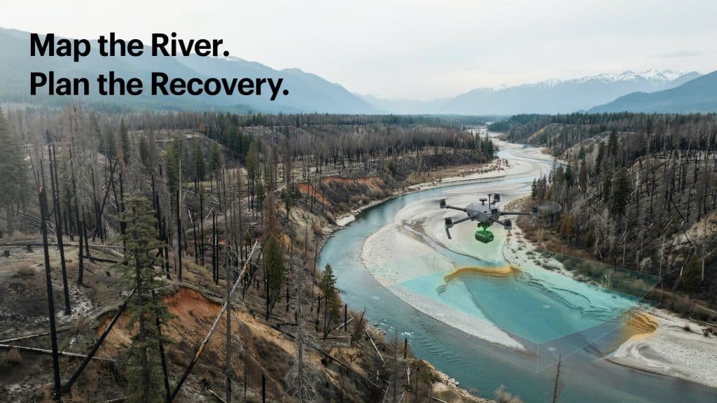
Drone Bathymetry for Post-Wildfire River Recovery is changing how we heal damaged rivers. After a fire, the riverbed you knew may no longer exist.
Flames strip the hillsides bare, and the next storm reshapes everything. Sediment, ash, and debris pour into the channel below.
The scale of this is sobering, and getting worse. By 2050, sediment could double in a third of western watersheds, per USGS.
To rebuild a river, you first need to see it clearly again. Here is how drone bathymetry makes that possible.
What is drone bathymetry?
Let’s begin with the basics before we go further. Drone bathymetry is the mapping of underwater depth from the air.
A drone carries a sensor that reads the shape of the riverbed. It captures the channel without anyone entering the water.
A standard bathymetric survey once needed boats, poles, or divers. Now much of that work happens safely from above instead. A bathymetric survey drone can map far more than people expect.
Many systems use bathymetric LiDAR, a green laser that pierces clear water. It measures the bed beneath the surface with real precision. Clear, calm water gives you the very best results.
Why do rivers need recovery after wildfire?
A burned watershed behaves very differently in the rain. With no plants to hold the soil, erosion accelerates sharply.
Moreover, a wildfire harms a river in several harsh ways.
- Bare slopes send sediment and ash downstream
- The channel fills, shifts, and loses its shape
- Spawning gravels and cool pools vanish
- Debris and logjams block the natural flow
That is why river recovery after wildfire is rarely optional. Effective wildfire river recovery depends on knowing the new conditions. This makes post-wildfire river recovery a race against the next storm.
How does drone bathymetry map a burned river?
Drone Bathymetry for Post-Wildfire River Recovery works in a clear sequence. It starts with a planned flight over the affected reach.
The drone flies low, capturing the bed and the banks together. This drone river mapping produces one seamless model of the channel.
Software then turns the data into depths, contours, and 3D surfaces. You see exactly where sediment settled and where scour occurred.
This same approach powers Drone Bathymetry for Post-Disaster Riverbed Mapping after floods and slides. Burned, rugged terrain rarely slows it down. Our post on LiDAR in tough terrain explains why.
What does the survey reveal?
A single flight tells you a great deal about the river. The data shows exactly what the fire and floods changed.
- Where sediment buried the old channel
- Where fast water scoured new holes
- How deep and wide the river now runs
- Which banks are eroding and unstable
- Where key habitat features were lost
Drone Bathymetry for Post-Wildfire River Recovery captures all of it in hours. With this picture, your team plans with real confidence.
How does the data guide restoration?
Good data turns a vague plan into a precise one. Engineers and biologists design from the river as it truly is now.
Drone Bathymetry for Post-Wildfire River Recovery shines in this restoration phase. Crews rebuild spawning beds, stabilise banks, and restore natural flow.
Drone Bathymetry for Flood and Wildfire Restoration guides each of those steps. You target the worst damage first, where it matters most.
That focus makes post wildfire river restoration faster and far cheaper. You also spend limited recovery budgets where they do the most good. Careful wildfire river restoration simply cannot rest on guesswork, so reliable drone data matters.
How do you monitor recovery over time?
Restoration is not finished when the work crews leave. A river keeps changing with every season and storm.
Repeat flights make post wildfire river monitoring simple and safe. You compare each survey to see how the channel heals.
Monitoring river restoration using drones reveals problems before they grow. You catch new erosion or failed structures early.
Over years, this record proves whether the recovery truly worked. It also guides the next round of careful action. Funders and regulators value that clear, honest evidence.
Frequently asked questions
What is the 1:1 rule for drones?
It means keeping your distance from people at least equal to your height. Fly at 40 metres, and stay 40 metres from bystanders.
Can LiDAR be used for bathymetry?
Yes, green wavelength LiDAR is built for exactly this task. It passes through clear water to map the bed below.
How are drones used in rescue operations?
They search fast, spot survivors, and assess hazards from above. That keeps rescuers safer during floods and other disasters.
How soon after a fire should you survey a river?
As soon as it is safe, ideally before the first big storm. An early baseline captures the river before more change hits.
Helping rivers heal, one flight at a time
A river damaged by fire can recover, with the right care. The first step is always seeing the new channel clearly.
Drone Bathymetry for Post-Wildfire River Recovery gives you that clear view. It is faster, safer, and kinder to fragile habitat.
From the first survey to long term monitoring, the data guides every choice. You protect fish, communities, and the water they all share. Few tools do so much for so little risk.
If a burned river needs your attention, we are ready to help. Tell us about the site, and Rekon Solutions will map the way forward.