When you order a LiDAR survey, what should actually land in your inbox? Understanding your drone LiDAR data deliverables is the difference between data you trust and data you quietly second guess.
A strong survey is more than a pretty 3D scan. It is a clear set of products, each with a job to do, backed by checks that prove the numbers are right.
Get that mix right, and you can plan, design, and build with confidence. Get it wrong, and small errors hide until they cost you later.
So let us walk through the core LiDAR data deliverables, from the raw point cloud to the finished ground model, and the QA that ties it all together.
What is a drone LiDAR point cloud?
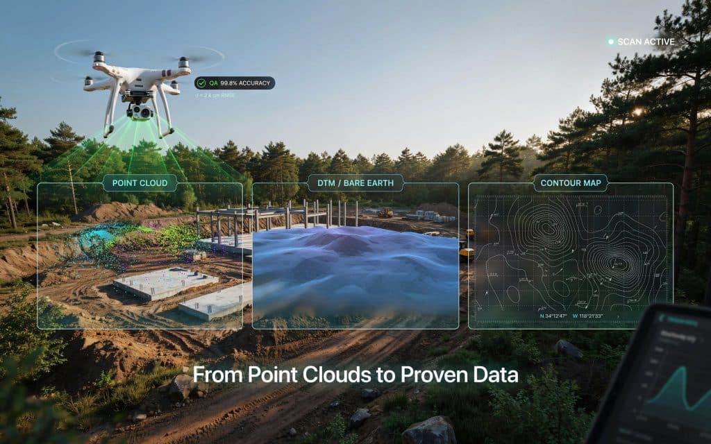
Everything starts with the point cloud. A drone LiDAR point cloud is a dense 3D collection of millions of measured points, each one a real spot the laser touched.
So what is a LiDAR point cloud in plain terms?
Picture a 3D photo made of dots, where every dot has an exact position in space. Together they form the shape of the ground, trees, buildings, and structures.
This raw LiDAR point cloud data is the source of truth for everything else. Every other deliverable you receive is derived from it, which puts the cloud at the centre of your drone LiDAR data deliverables.
How do point clouds become ground models?
The point cloud is powerful, but it is not the final product for most jobs. Next comes classification, where software and analysts sort points into groups like ground, vegetation, and buildings.
Once the ground points are separated, you get a LiDAR ground model. This bare earth surface is the foundation for design and volume work.
There are two key surfaces to know. The digital terrain model LiDAR produces shows the bare ground with plants and structures stripped away. The digital surface model LiDAR builds includes everything on top, such as canopy and rooftops.
That bare earth view is what makes LiDAR special, since it reveals the ground hidden under forest.
We explain that strength in our post on how LiDAR performs in dense forest and mountain terrain. These ground models are the heart of most drone LiDAR data deliverables.
What other LiDAR outputs can you receive?
From those surfaces, a survey can produce a whole family of LiDAR mapping outputs. Contour lines, slope maps, and elevation models all come from the same dataset.
You can also receive breaklines, volume reports, cross sections, and colourized point clouds. The right LiDAR data products depend on your project, so it pays to agree on them up front.
This is part of strong drone LiDAR data deliverables. A clear list of outputs means no surprises when the files arrive.
How does QA prove your data is accurate?
Here is the part that separates a professional survey from a risky one. Quality assurance proves your data is accurate, not just detailed.
It starts with ground control points. These are marked spots on the ground with positions measured by a precise GPS survey, and they anchor the whole dataset to real world coordinates.
How do you measure ground control points? A surveyor records each one with survey grade GNSS, often using RTK or static methods for the tightest results.
Then come independent checkpoints. These are extra measured points, kept separate from the ones used to build the model, and they test how close the data really is.
A well known rule from the USGS and ASPRS standards is that your checkpoint survey should be about three times more accurate than the LiDAR itself.
On standards, the USGS sets QL2 as its minimum quality level for national elevation data, which means at least 2 points per square metre and vertical accuracy near 10 centimetres.
Good drone work often far exceeds that. For more on the numbers, see our guide on how accurate drone LiDAR is for engineering and construction projects.
Finally, you should receive a validation report. This QA is what makes your drone survey deliverables trustworthy, since you can read the measured accuracy in writing rather than taking it on faith.
What should you ask for before a survey?
Strong drone LiDAR data deliverables start with a clear conversation before the flight. Ask for the point cloud, the bare earth model, and the specific maps your team needs.
Just as importantly, ask how the data will be checked. A provider that talks openly about ground control, checkpoints, and reporting is one that takes accuracy seriously.
This is where the right partner matters. Rekon Solutions plans each survey around your deliverables and proves the quality with clear, documented QA.
Frequently asked questions
What is a LiDAR drone survey?
It is a survey where a drone carries a laser scanner to map the ground and objects in 3D. The result is a precise point cloud and the models built from it.
What are the 4 components of LiDAR?
A LiDAR system has four main parts. These are the laser scanner, a GNSS receiver for position, an IMU for orientation, and a timing computer that ties them together.
What techniques are used in LiDAR data processing?
Common steps include trajectory processing, point cloud alignment, noise removal, classification into ground and non ground points, and surface modelling. Each step shapes the final drone LiDAR data deliverables.
Why do ground control points matter?
They anchor your data to real coordinates and let you prove its accuracy. Without them, even a dense point cloud can drift away from the truth.
Why trustworthy deliverables matter most
At the end of the day, drone LiDAR data deliverables are only as valuable as your confidence in them. A dense point cloud, a clean ground model, and the right maps mean little without QA to back them up.
The best surveys give you both. Detailed products, plus clear proof that the numbers hold, so your team can act without hesitation.
If your next project needs LiDAR data you can stand behind, tell us what you need to deliver. We will build the products and the QA to match, so the data works as hard as you do. Get in touch with our team.
