Many teams invest in drone LiDAR services for mapping without fully understanding what they are receiving.
They hear terms like point clouds, terrain models, and aerial surveys, but the actual deliverables often remain unclear.
As a result, project expectations and final outputs do not always align.
This is why understanding drone LiDAR services matters before your project begins.
LiDAR delivers far more than aerial visuals or basic topographic maps. It creates detailed terrain intelligence that supports engineering, planning, and infrastructure decisions.
However, not all providers deliver the same quality or level of detail. Knowing what to ask for helps you avoid incomplete datasets and expensive misunderstandings later.
Let’s break down what you actually receive from a professional LiDAR workflow and what smart teams should ask before hiring anyone.
What Drone LiDAR Services Actually Provide
At the core of drone LiDAR services is laser-based terrain measurement. A drone-mounted LiDAR sensor sends thousands of laser pulses toward the ground every second. The system measures how long those pulses take to return and converts that information into spatial data.
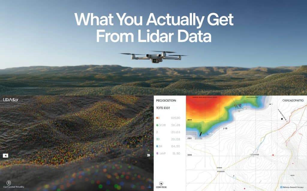
This process creates highly detailed 3D datasets known as point clouds. These point clouds contain millions of measured points across the terrain. From there, the data is processed into usable engineering and mapping deliverables.
Most professional LiDAR drone surveying services provide several outputs instead of just one map. Understanding those deliverables helps you evaluate the real value of the survey.
The Main Deliverables You Should Expect
Every project has different requirements, but there are several standard outputs you should expect from quality drone LiDAR services.
1. Point Cloud Data
Point clouds are the raw foundation of LiDAR mapping. They represent the terrain and surrounding features in 3D space. Engineers and GIS professionals use them for analysis and modeling.
2. Digital Terrain Models
These models show the bare earth surface after vegetation and structures are removed. They are essential for grading, drainage, and infrastructure planning.
3. Contours and Elevation Maps
Processed contour lines help visualize terrain elevation changes clearly. These outputs support construction and land development projects.
4. Orthomosaic Imagery
Some providers combine LiDAR with aerial imagery. This creates visually detailed site maps that improve interpretation and communication.
These are common LiDAR deliverables engineering survey teams typically request during projects.
Why Drone LiDAR Mapping Canada Is Growing Rapidly
The demand for drone LiDAR mapping Canada continues increasing across multiple industries. Large project areas, remote terrain, and dense vegetation create challenges for traditional surveys. LiDAR solves many of these problems efficiently.
Infrastructure, mining, forestry, and construction sectors all benefit from aerial mapping technologies. In particular, aerial LiDAR survey Canada projects help teams capture terrain data safely and quickly across difficult landscapes.
Additionally, Canadian projects often involve rugged terrain and environmental considerations. LiDAR provides accurate elevation information without extensive ground access.
According to Natural Resource Canada’s National Elevation Data Strategy, LiDAR plays a major role in centimeter-level 3D elevation data for their terrain analysis, flood modeling, and infrastructure planning nationwide.
This growth reflects increasing confidence in LiDAR accuracy and efficiency.
You can further read about how LiDAR performs in Mountain Terrain and Dense Forrest.
What Is Drone LiDAR Used For
Many organizations understand that LiDAR creates maps, but they often overlook its broader capabilities. In reality, what drone LiDAR is used for extends far beyond simple surveying.
Here are some common applications:
- Terrain and elevation mapping
- Construction site planning
- Forestry and vegetation analysis
- Infrastructure inspections
- Mining and stockpile measurement
- Flood risk and drainage studies
- Corridor mapping for roads and utilities
These UAV LiDAR mapping applications continue expanding as drone technology advances.
Understanding LiDAR Mapping vs Photogrammetry
One of the most common questions teams ask involves LiDAR mapping vs photogrammetry. Both methods create spatial data, but they work differently and perform best under different conditions.
Photogrammetry uses overlapping images to reconstruct terrain visually. LiDAR uses laser pulses to measure elevation directly. Because of this, LiDAR performs much better in forests or heavily vegetated areas.
Photogrammetry often provides stronger visual textures and lower operational costs. LiDAR, however, delivers more reliable elevation data in complex terrain.
A good provider should explain which method best fits your project instead of pushing a single solution for every site.
4 Questions Smart Teams Must Ask Before Hiring
Before choosing a provider, smart teams ask detailed questions about workflows, deliverables, and accuracy. This helps prevent confusion later in the project.
1. What level of accuracy do you guarantee?
Understanding LiDAR survey accuracy Canada standards is essential for engineering work. Ask how accuracy is validated and documented.
2. What deliverables are included?
Do not assume every provider delivers the same outputs. Clarify exactly what files and models you will receive.
3. How is vegetation filtered from terrain?
This is important for forestry, mining, and infrastructure projects. Ground classification quality affects final terrain accuracy.
4. What industries have you worked with?
Industry experience often reveals how adaptable the provider is to project challenges.
These conversations help you assess technical expertise more effectively.
Why Drone LiDAR Data Collection Requires Expertise
Collecting LiDAR data is only part of the process. Proper drone LiDAR data collection also depends on flight planning, calibration, and environmental conditions. Poor workflows can reduce accuracy significantly.
For example, flight altitude and overlap settings directly affect point density. Weather conditions may also influence data quality. Experienced teams understand how to manage these variables properly.
Additionally, processing LiDAR datasets requires technical knowledge. Ground classification and quality control play major roles in final deliverables.
If your project depends on accurate terrain data, working with experienced professionals matters.
What Influences Drone LiDAR Cost Canada
Many factors affect drone LiDAR cost Canada projects. Pricing depends on terrain complexity, vegetation density, project size, and required accuracy. Deliverable types also influence overall costs.
For example, engineering-grade terrain models require more processing time than basic aerial outputs. Remote locations may also increase operational expenses.
However, focusing only on price can create problems later. Lower-cost providers may cut corners on processing, validation, or reporting. Smart teams evaluate value instead of comparing quotes alone.
If you are planning a survey project, Rekon Solutions can help you understand which LiDAR workflow best supports your goals.Get in touch
How LiDAR Supports Better Project Decisions
The true value of drone LiDAR services comes from the decisions they support. Accurate terrain data improves engineering confidence and reduces uncertainty during planning.
Project teams can identify elevation challenges, drainage issues, and terrain risks earlier. This reduces redesigns and unexpected field adjustments later.
Additionally, detailed mapping improves collaboration between engineers, planners, and contractors. Everyone works from the same reliable dataset.
FAQs
1. What are drone LiDAR services used for?
They support terrain mapping, engineering surveys, infrastructure planning, and vegetation analysis.
2. Is LiDAR more accurate than photogrammetry?
LiDAR generally provides stronger elevation accuracy, especially in dense vegetation and rugged terrain.
3. What deliverables come from a LiDAR survey?
Common outputs include point clouds, terrain models, contours, and orthomosaic imagery.
4. How much does drone LiDAR cost in Canada?
Costs vary depending on project size, terrain complexity, and required deliverables.
Moving Forward with Better Mapping Expectations
A successful mapping project starts with understanding what you are actually buying. Drone LiDAR services provide much more than aerial imagery when handled correctly. They deliver detailed terrain intelligence that supports smarter engineering and planning decisions.
By asking better questions about workflows, deliverables, and accuracy, you reduce project risks significantly. You also ensure the final outputs truly support your operational goals.
If you are evaluating LiDAR providers for an upcoming project, Rekon Solutions can help you understand which deliverables best fit your requirements. Contact us today.
When you know what to ask for, you get far more value from your data.
