“Digital twin” has become one of those terms that means something different in every sales deck. In some industries it describes a live software model fed by thousands of sensors. In others it means a nice-looking 3D render.
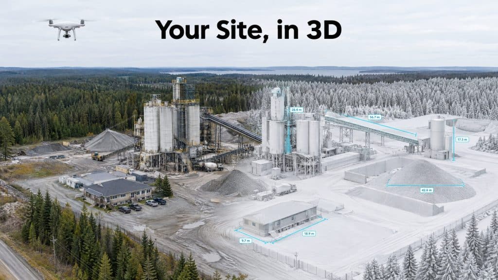
For most site owners, engineers and project managers, the useful version sits in between: an accurate, measurable 3D copy of a real site, built from drone imagery, that you can open on a laptop and work from. That is the kind of digital twin drone photogrammetry produces, and it is worth understanding what it can and cannot do before you commission one.
What a photogrammetry digital twin actually is
Photogrammetry builds 3D geometry from hundreds or thousands of overlapping photos. Software matches the same features across many images and works out where each one sits in space. We explain the process step by step in how photogrammetry builds a map from overlapping photos.
From one well-planned capture, a site twin usually includes:
- A textured 3D mesh: the realistic model you can orbit, zoom and inspect
- A dense point cloud: the measurable 3D data behind the mesh
- An orthomosaic: a scaled, map-accurate image of the whole site from above
- Surface models: for elevations, slopes and volumes
The key word is measurable. A properly controlled twin is georeferenced, so every point has real coordinates. You can measure a distance, a height or a volume on screen and trust the number to the accuracy the survey was designed for.
What makes it a “twin” and not just a model
A single 3D model is a snapshot. It becomes a twin when it is kept current: the same site flown again on a schedule, processed the same way, and compared against the earlier captures and against the design.
That repetition is where most of the value comes from. One capture tells you what the site looks like. A series tells you what changed, when, and by how much.
How sites actually use them
Remote inspection and measurement. Engineers, managers and consultants can check conditions, measure features and answer questions without travelling to site. For remote operations in BC and Alberta, that alone can save days.
Progress tracking against design. Overlay the design on the current twin and you can see what has been built, what is behind and where work has gone off-plan. Earthworks, structures and stockpiles can all be quantified from the same capture.
Planning changes and expansions. When a plant adds a building, a mine adds a bench or a yard changes its layout, designers can start from an accurate model of what exists rather than from old drawings that may no longer match reality.
Stakeholder communication. A model that anyone can orbit on screen explains a site faster than a set of plan views. Owners, regulators, neighbours and new crew members all grasp it quickly.
Safety planning. Crews can review access routes, exclusion zones, edges and hazards in the model before they set foot on site.
A dated record. Each capture becomes evidence of site conditions on a specific day, which is valuable if quantities, damage or responsibilities are ever disputed.
Where photogrammetry twins have limits
Being clear about the limits is what keeps a digital twin useful rather than misleading.
- It cannot see through vegetation. The camera records the top surface. Ground under dense trees or brush needs LiDAR.
- Some surfaces are hard to model. Water, glass, polished metal and large plain surfaces give the software little to match, and can leave holes or noise.
- Thin features are difficult. Wires, rails, antennas and slender members are often incomplete in a photogrammetry model.
- Accuracy depends on control. Without proper positioning, through RTK or PPK and independent check points, the model can look perfect and still be off. Our guide to RTK, PPK and ground control explains the options.
- Interiors need other tools. Inside buildings, tunnels and underground, scanning methods such as SLAM LiDAR take over.
For complex sites, the strongest twins combine methods: photogrammetry for the realistic texture, LiDAR for the ground and fine detail.
Getting a twin you can actually use
Before the first flight, decide:
- What questions the twin needs to answer. Measurement, progress, inspection or communication each drive different capture settings.
- How accurate it needs to be. This sets the resolution, the flight plan and the control.
- How often it will be updated. A consistent schedule and method make captures comparable.
- Who will open it, and in what software. A twin nobody can open is just storage.
- Whether you need side views. Facades, walls and structures need angled imagery, not only straight-down photos.
Get those right and a drone-built digital twin becomes one of the most practical tools on a site: one accurate model that engineers, managers and owners can all work from.
Want a measurable 3D model of your site? Let’s talk about what it needs to do →