Mapping has always been essential for planning, design, and decision making.
However, traditional methods often take time, require heavy resources, and still miss important details.
And as projects grow more complex, the demand for faster and more accurate data continues to increase.
This is where drone photogrammetry is transforming how you approach mapping.
By using aerial images and advanced processing, you can generate precise maps and models in less time.
Moreover, this approach improves efficiency while maintaining high levels of accuracy across projects.
If you are looking for reliable and scalable mapping solutions, understanding how this technology works can help you make better decisions.
Let’s walk through how photogrammetry is changing mapping workflows for you.
What is Drone Photogrammetry and How Does It Work
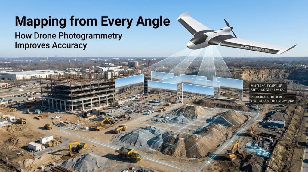
Drone photogrammetry uses drones to capture overlapping aerial images of a site from multiple angles. These images are then processed using specialized software to create accurate maps and 3D models. This process is known as photogrammetry mapping, and it relies on identifying common points across images.
The result is a highly detailed output such as orthomosaics, point clouds, and 3D photogrammetry models. These outputs help you visualize terrain, structures, and site conditions with clarity. As a result, aerial photogrammetry becomes a powerful tool for modern mapping needs.
This method also supports consistent data capture across large areas. You can repeat surveys over time and compare results easily. That makes geospatial data collection more reliable and actionable.
Why Aerial Photogrammetry is Changing Mapping Workflows
Mapping workflows are evolving because projects now require faster turnaround and higher accuracy. Traditional survey methods can be slow and labor intensive, especially for large or complex sites. In contrast, aerial mapping drones can cover vast areas quickly and safely.
With drone mapping services, you can reduce field time significantly. Data collection that once took days can now be completed in hours. Additionally, automated processing speeds up data delivery, helping you move projects forward faster.
Accuracy is another major advantage. By using image-based mapping, you can capture fine details that may be missed through manual surveys. This improves planning, reduces rework, and supports better project outcomes.
Key Benefits of Drone Photogrammetry for Your Projects
You will notice several advantages when using drone photogrammetry for mapping. These benefits directly impact efficiency, cost, and decision making across your projects.
First, speed is a major factor. Drone survey mapping allows rapid data collection without extensive manpower. This helps you meet tight deadlines without compromising quality.
Second, safety improves significantly. Surveyors no longer need to access hazardous or difficult terrain. Instead, drones handle data capture from a safe distance.
Third, cost efficiency becomes clear over time. Fewer resources are needed for data collection and processing. As a result, photogrammetry survey methods reduce overall project costs.
Finally, data quality improves. High resolution imagery ensures better photogrammetry mapping outputs. This supports accurate measurements and reliable analysis.
Where Drone Photogrammetry Delivers the Most Value
Drone photogrammetry is used across many industries because of its flexibility and precision. In construction, it supports site planning, progress tracking, and volume calculations. You can monitor changes over time using consistent aerial data.
In infrastructure projects, aerial photogrammetry helps inspect roads, bridges, and utilities. It provides clear visuals without disrupting operations. This makes inspections faster and more efficient.
Mining and environmental projects also benefit from image-based mapping. You can analyze terrain, monitor changes, and manage resources more effectively. These insights support better long term planning.
If you want to see how aerial data supports inspections, you can read our blog on drone inspections.
Improving Accuracy with Photogrammetry Mapping
Accuracy is critical in any mapping project. With drone photogrammetry, accuracy depends on factors like image overlap, flight planning, and processing quality. When done correctly, results can reach near survey grade levels.
For example, proper overlap ensures that each point is captured multiple times. This improves alignment during photogrammetry survey processing. As a result, your outputs become more precise.
Ground control points can further enhance accuracy. These reference points help align aerial data with real world coordinates. This improves the reliability of your geospatial data collection.
Additionally, consistent flight paths and stable conditions contribute to better results. Together, these factors ensure high quality outputs from drone mapping services.
Choosing the Right Approach for Your Mapping Needs
Not every project requires the same level of detail or approach. However, drone photogrammetry offers flexibility for different use cases. Whether you need quick visuals or detailed models, this method can adapt to your needs.
You should consider project size, required accuracy, and timeline when choosing a mapping method. For many projects, aerial mapping drones provide the right balance of speed and precision.
Working with experienced professionals also makes a difference. At Rekon Solutions, mapping workflows are designed around your specific project goals. This ensures that the data you receive is both accurate and actionable.
If you are planning a project and need reliable mapping support, feel free to contact Rekon to discuss your requirements.
Integrating Photogrammetry with Modern Mapping Technologies
Modern mapping often combines multiple technologies for better results. For example, drone photogrammetry can complement LiDAR data for more comprehensive insights. While LiDAR captures elevation accurately, photogrammetry adds visual detail.
This combination improves both accuracy and usability of mapping outputs. You gain a complete understanding of terrain and structures. That supports better planning and execution.
You can also explore our blog on LiDAR mapping for vast landscapes to understand how both technologies work together.
As mapping technology continues to evolve, integrating these methods will become more common. This ensures that your projects benefit from the best available tools.
FAQs
How does drone photogrammetry work in mapping
Drone photogrammetry captures overlapping images and processes them into maps and models. This creates accurate visual and spatial data for analysis.
How accurate is photogrammetry mapping
With proper planning and processing, photogrammetry mapping can achieve high accuracy. Ground control points further improve precision.
What is the benefit of aerial photogrammetry
Aerial photogrammetry allows fast data collection over large areas. It improves efficiency while maintaining detailed and reliable outputs.
Is drone photogrammetry cost effective
Yes, drone mapping services reduce field time and manpower needs. This leads to lower overall project costs over time.
Moving Forward with Smarter Mapping
Mapping is no longer limited by slow processes or incomplete data. Drone photogrammetry gives you faster, safer, and more accurate results across projects. It helps you make informed decisions with confidence.
As projects become more demanding, adopting modern solutions becomes essential. Drone survey mapping ensures that you stay ahead with reliable data and efficient workflows.
If you are ready to improve your mapping approach, contact Rekon Solutions today. Our team will help you get accurate results that support your project goals.
