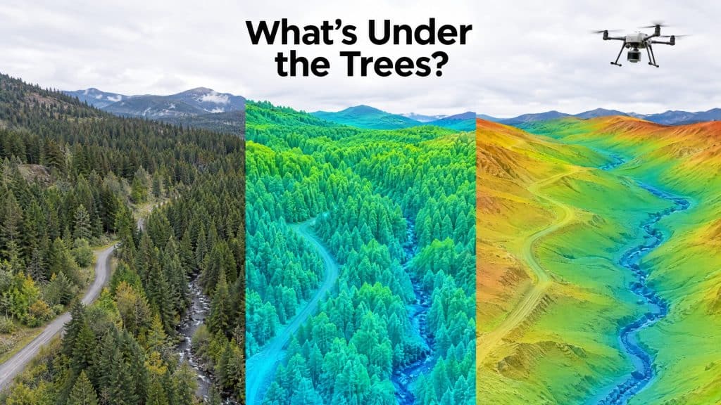
Order “elevation data” from three different providers and you can get three different products back, all called something similar. One shows the tops of the trees. One shows the ground under them. One is labelled DEM and could be either, depending on who made it.
That confusion costs time. A drainage designer who receives a surface model full of tree canopy cannot use it. A forester who receives bare earth cannot measure tree height from it. So before you order anything, it pays to know exactly what a digital terrain model is, and how it differs from its two close relatives.
The digital surface model (DSM): everything the sensor hit first
A digital surface model records the highest surface the sensor saw at every point: treetops, rooftops, power lines, parked equipment, stockpiles, and open ground where nothing covers it.
With LiDAR, the DSM is built mostly from the first returns of each laser pulse. With photogrammetry, it is built from whatever the camera could see, which is always the top surface.
A DSM is the right product when the objects on the ground are the point: line-of-sight studies, canopy and vegetation analysis, clearance checks around structures, or a visual 3D model of a site.
The digital terrain model (DTM): the ground with everything removed
A digital terrain model is the bare earth. Vegetation, buildings and other above-ground features are classified out, and only the ground surface remains.
This is the product engineers usually mean when they ask for topography. Drainage design, road and pad grading, slope stability work, flood modelling and volume calculations all depend on knowing where the real ground is, not where the treetops are.
Many DTMs also carry breaklines: defined edges such as ditch bottoms, road shoulders, crests and toes of slopes. Breaklines keep a terrain model sharp where the ground changes abruptly, instead of letting the software smooth a ditch into a gentle dip.
The digital elevation model (DEM): the umbrella term
DEM is the term that causes most of the confusion, because it is used two ways.
- As an umbrella term for any gridded elevation model, surface or terrain.
- As a synonym for the bare-earth model, which is how most surveyors and engineers use it day to day. In our own work, when a client asks for a DEM, they almost always mean bare earth, and we confirm it before we process.
Canada’s national product shows how the terms fit together. Natural Resources Canada’s High Resolution Digital Elevation Model (HRDEM) is the umbrella dataset, and it contains both a DTM and a DSM, mostly generated from airborne LiDAR.
The safe rule: never order “a DEM” without saying whether you need the ground or the surface.
A useful bonus: the difference between the two
Subtract the DTM from the DSM and you get the height of everything standing on the ground. In forestry this is called a canopy height model. On a construction site, the same calculation shows the height of stockpiles, structures and vegetation in one layer. Order both models from the same survey and this product comes almost free.
Why LiDAR usually wins for terrain models
A good terrain model needs ground points, and that is where the capture method matters.
A camera only sees the top surface. Under dense trees or brush, photogrammetry has no way to reach the ground, so the “terrain” it produces is really the vegetation. LiDAR pulses slip through small gaps in the canopy and return from the ground below, which is why LiDAR is the standard method for bare-earth mapping in forested terrain. We cover the trade-offs in more detail in our post on how LiDAR performs in dense forest and mountain terrain.
On open, bare sites such as quarries, cleared lots and stockpile yards, photogrammetry can produce an excellent terrain model at lower cost, because the camera can see the ground directly.
What to specify when you order a digital terrain model
To get a terrain model you can drop straight into your design software, put these in writing before the flight:
- Which models you need: DTM only, or DTM and DSM together
- Grid resolution: the cell size of the raster, for example 0.25 m or 1 m
- Breaklines: whether you need them, and for which features
- Coordinate system and vertical datum: in Canada, typically NAD83(CSRS) with heights on CGVD2013, unless your project uses something else
- File formats: GeoTIFF for rasters, LAS or LAZ for the classified point cloud, and your CAD format for contours and breaklines
- Accuracy: a stated vertical accuracy, checked against independent ground points
Ask for the classified point cloud as well. It is the source every model is built from, and it lets you or another consultant generate new products later without flying again. Our guide to drone LiDAR deliverables explains what a well-classified cloud should include.
The short version
- DSM: the top of everything. Use it when the objects matter.
- DTM: the bare ground. Use it for design, drainage, grading and volumes.
- DEM: a general term, often used for bare earth. Always confirm which one you are getting.
Need a terrain model for design? Tell us about your site and we’ll specify the right product →